


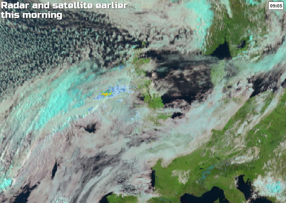
A front across the country is dividing fresher air in the north and humid air in the south. That front will also bring some increasingly heavy rain into the north later today and overnight.
Although weak at the moment, a front straddling central parts marks the boundary between brighter, fresher weather in the North and humid conditions in the South. For much of Scotland, and northern England it's a bright start with some sunshine, and it's mainly dry, apart from a scattering of sharp showers over West Scotland. Northern Ireland is mostly cloudy, with Tyrone, Fermanagh and southern parts of the province seeing some rain later in the morning. Across Wales and the remainder of England it's humid with a good deal of cloud, but apart from patchy light rain and drizzle mostly in the West and South West, it's dry. Through the morning, however, skies may break at times to give a few warm sunny intervals mainly across southern counties and the South East.
Most of Scotland and the far North of England see further sunny spells into the afternoon with remaining showers towards Highland fading, as a brisk Westerly wind in the North at first 'backs' South West or South and decreases. The rest of northern England sees cloud increasing from the South, but apart from patchy mostly light rain or drizzle in the West it should stay dry. Northern Ireland however and perhaps parts of Dumfries turn wet through the afternoon, with top temperatures 18 or 19C in the East and 15 to 17C in the West.
Nice weekend on the way?
Click here for the forecast
Over remaining parts of England and Wales cloud, much of it quite low will tend to come and go. It'll also be a humid afternoon. With the best of the cloud breaks in the South and East and where you have shelter from a moderate or fresh South West wind. Although mainly dry, the cloud will give some patchy light rain or drizzle, mostly in the West and over exposed coasts and hills making it misty at times here.
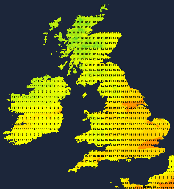
Where the sun comes through it'll become very warm, with temperatures reaching 24c, locally 25C across parts the South East, making it ideal for the tennis at the Queens Club, although 20 to 23C will be a more general maximum.
As the front returns northward into the evening, much of Scotland turns wet overnight, after a fine end the day in the far North. Northern Ireland also has a wet evening, where the rain will turn showery from the North West during the night. Over northern England and North Wales, it'll be cloudy, with patchy rain turning heavier towards dawn to the West of the Pennines and over Clwyd.
Elsewhere it'll be mainly dry, with skies breaking at times mostly in the East and South to give a few clear intervals. After a great show last night, there could be another opportunity to view noctilucent clouds tonight.
Winds will be light in the South and over Scotland but otherwise moderate or fresh South Westerly, with perhaps quite blustery conditions across the far North of England and The Borders for a time. Lowest temperatures over Scotland will be 5 or 6C in the far North. Elsewhere 9 to 13C is more likely, with another humid night in the South where temperatures are unlikely to fall below 15 to 17C.
A cold front will introduce somewhat cooler, fresher conditions to most parts from the North West tomorrow, but not before East Anglia, the South and South East see further tastes of summer. Here sunny intervals could lift temperatures into the mid-twenties Celsius again by the afternoon, that could 'trigger' the odd perhaps sharp shower towards evening. Lincolnshire and the East Midlands could also see some warm sunny intervals at first, before cooler, fresher weather with mostly light showers already moving into Wales and remaining part of England arrives.
Residual rain soon clears from Scotland leaving sunny spells, but showers will develop especially in the North and West where some could be heavy and thundery. Northern Ireland sees fewer showers and more in the way of sunny spells. A moderate or fresh wind will become West or North West, with top temperatures away from the South East, 17 to 20C across England and Wales and 14 to 17C over Scotland and Northern Ireland.
East Anglia and the South East see a few showers into the evening, then clearing skies after dark. There'll also be scattered showers over Scotland, Antrim and Cumbria for a time, but these too should fade to leave broken skies after dark. A West or North Westerly breeze will give a noticeably cooler, fresher night, with lowest temperatures 9 to 12C in the South and 5 to 8C in the North.


