After a long spell of blocked weather, Atlantic weather systems will be making a comeback later next week.
Once upon a time, our weather used to mostly come from the Atlantic, with westerly winds the most common, bringing regular visits from Atlantic lows and weather fronts. It may seem far-fetched, but that reality is coming back this week as the blocked weather finally starts to subside. It's actually quite a regular occurrence at this time of year - May tends to be a blocked month with lots of high pressure, but the 'June Monsoon' usually turns up to blow that away for a period of time.
That's to come later in the week, in the meantime though; it's more of the same - a mix of sunnier bits, cloudier bits but also with some big downpours and thunderstorms. Speaking of which, if you've ever driven up the A9 in Scotland in the winter, snow can often make conditions a bit tricky. In the middle of summer, you don't expect to end up with similar problems caused by hail though, but that's just what happened yesterday.
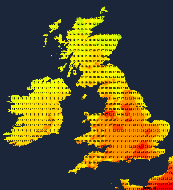
Today, the sun will break through more widely than it did yesterday, with much of the country enjoying a fine, warm end to the weekend. Showers and storms will spoil it for a few though, with Eastern and Southern Scotland, Northern England, Western Wales and perhaps also Southwest England at highest risk of catching one - especially during the afternoon and evening. Even in those places, you're not guaranteed to see any action, but if you do, the rain could be torrential, with lightning, hail and gusty winds all possible.
Temperatures today will widely reach 20-25c across England and Wales, albeit still cooler down the east coast. For Scotland and all of Ireland, 17-21c is more likely.
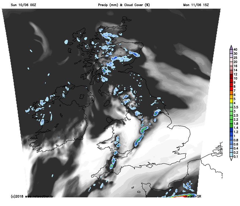
Most showers will ease overnight to leave much of the country dry. Then Monday sees a bit of a change, with Scotland and Northeast England seeing a lot more in the way of cloud than today which will make for a much cooler feel. Whereas further south, it's another bright or sunny and warm day. There'll be some showers here and there, but most places will stay clear of them.
 The southern half of England and Wales will see temperatures on a par with today, elsewhere though, the mid to perhaps high teens will be the peak.
Tuesday will see more sun return to the north of the country, with all parts having a day or sunny spells with the risk of isolated showers. Temperatures will be down on recent values though, with maxes of 16-20c, as winds blow down from a northerly direction.
Wednesday sees change proper starting to show its face. As winds swing into the southwest in western parts, and a weather front bringing rain edges across into Ireland and eventually northwest Scotland - finally breaking a long run of very dry weather here. In the meantime, much of the UK will have another dry, often sunny day with temperatures perhaps up a touch compared to Tuesday.
By Thursday, the band of rain will be moving southeast across the whole country with the heaviest rain likely to be in the north and west, as it turns more patchy further southeast. Behind the rain-band, sunny spells will develop, but with some showers in the north and west. It'll be blustery too, with gales possible across the north of Scotland for a time.
The changeable pattern then locks in as we end the week and move into next weekend, with more showers or longer spells of rain moving through at times. The heaviest and more frequent rain will often affect the northwest of the country, with those further southeast seeing more in the way of drier, brighter and warmer interludes between any wetter spells.