


Warm sunny spells for most to end the week and into the weekend, but with increasing humidity a risk of thundery showers too.

The weather is stuck in a bit of rut at the moment, with slack areas of high and low pressure wallowing around Europe, with light winds and little impetus to change the weather much day-by-day. Today, tomorrow and the weekend will have a similar theme of morning grey skies affecting eastern areas burning back to the coasts, then spells of warm sunshine with light winds for many. However, with low pressure, heat and humidity over the near continent expanding north there will be the additional risk over the next few days of a few showers, perhaps thundery, across the south. There does seem to be growing confidence of a change through next week, as a strengthening jet stream over the Atlantic brings in low pressure systems towards the UK and, with it, a cooler, windier and more unsettled spell of weather.
Return of strong Atlantic jet stream next week?
But for now, the now familiar routine of low cloud or Haar greets eastern coastal areas of Britain and also skies are generally cloudy across southern England. There have been some storms over Kent and coastal East Anglia overnight and there will be further well scattered thundery showers this morning across the south of England. Elsewhere, despite some low cloud around some coasts in the far northwest, it’s a sunny start.
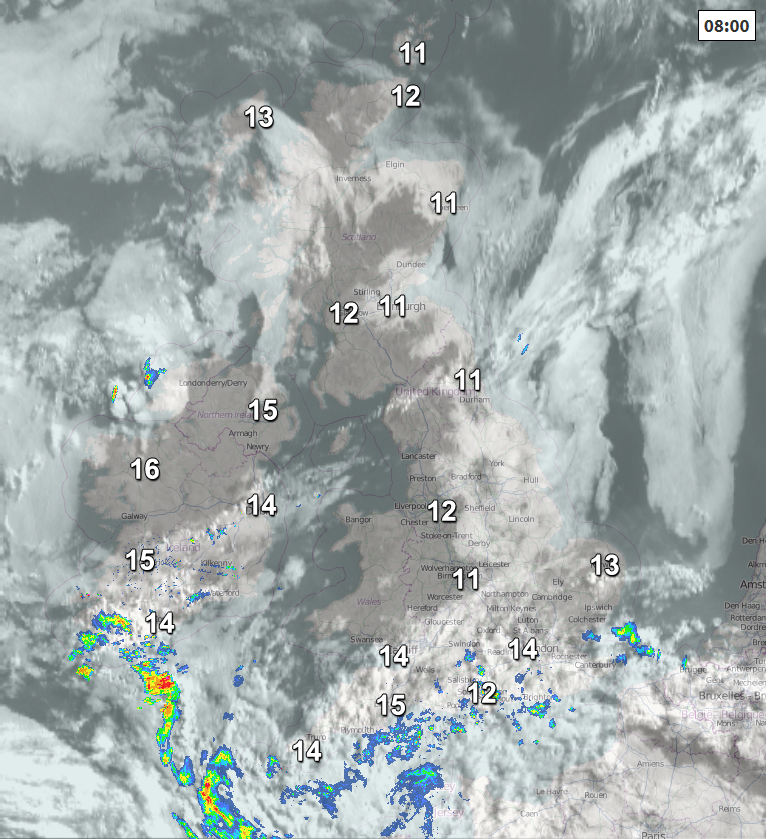
The grey skies in the east will burn back to the coasts through the morning, so these cloudy areas of eastern Scotland eastern England will join much of the UK to a dry day with warm sunny spells. More in the way of cloud across southern England and south Wales, which will continue to produce some well-scattered occasionally heavy and perhaps thundery showers through the day, but many in these areas may miss them. There is also a chance of a few heavy showers developing across western Scotland and Northern Ireland this afternoon.
Winds generally light today, with temperatures widely reaching 20-22C inland across the UK, perhaps 23-24C across southern England. Cooler around coasts – where temperatures of 15-17C will be more common.
A few thundery showers continuing to affect southern counties of England and Wales overnight – where it will be muggy and cloudy at times, also low cloud and haar returning inland from North Sea coasts across eastern areas. Otherwise dry with clear spells and fresher across western and northwestern areas.
A grey start again across eastern areas, low cloud burning back to coasts to join most areas to another day of warm sunny spells. Like today, some well scattered thundery showers moving or developing northwestward, this time more likely across central and western areas of England along with Wales and also developing across Ireland, Northern Ireland and western Scotland – but they will be hit and miss. Temperatures reaching 15-19C in the north, 20-23C inland across England and Wales, but cooler around coasts.
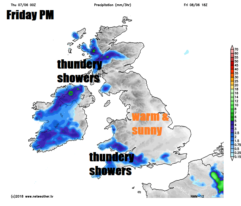
Many areas dry with warm sunny spells again on Saturday, once early grey skies clear eastern areas, a risk thundery showers moving into the far south by the evening and also developing across NW Scotland, Ireland and Northern Ireland. Warm in the sunshine, temperatures widely in the low twenties, perhaps 25C in the southeast.
Rainfall for the weekend: increasing showers in places
Afternoon highs on Saturday and Sunday
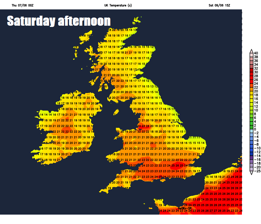
Perhaps a more widespread risk of thundery downpours spreading north across parts of England and Wales on Sunday, despite this, it will be warm and muggy with temperatures reaching the low to mid-twenties. Mostly dry and sunny for Scotland.


