


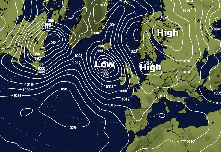
With high pressure slowing but not totally blocking Atlantic fronts from progressing across the country, we'll see a mix of weather over the coming days.
May has a reputation for 'blocking', which often brings chilly winds of North European origin across the country. Currently, we have a partially 'blocked' situation, which is causing Atlantic systems to slow down as they approach. This can result in forecasting problems, with the latest front already into Ireland likely to become slow moving over Scotland and the East of England over the weekend.
No problems for today though, with central and eastern parts apart from thin high cloud having a dry, bright day. There'll be some sunshine, particularly during the morning, before cloud thickens from the West through the afternoon. Rain some of it heavy already moving into Northern Ireland, will be followed by a clearance from the West that should have reached most of the province by evening. West Scotland, the Isle of Man, West Wales and the South West also see some rain by late afternoon, as cloud steadily thickens here through the day.
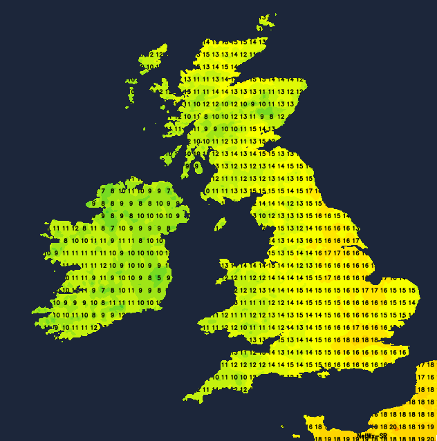
Light winds at first in the East will freshen from the South East or South to perhaps give some strong gusts across exposed coasts of Northern Ireland into the afternoon. Temperatures will be close to normal, reaching 12 to 15C in the North and West and 17 or 18C locally 19C in the East and South.
Central and eastern areas continue dry into the evening, but a threatening sky eventually brings some rain overnight. There'll be heavier bursts across North East England but further South, it could well stay dry in places until morning. After some wet weather into the evening in the West, drier weather moves in from the South overnight, with clearer skies probably as far North as Dumfries by dawn. Scotland sees bursts of rain advancing slowly North and East across the country, while Northern Ireland has a mixture of clear intervals and scattered showers these mostly in the North and West.
A light or moderate locally fresh at first South Easterly wind, will 'veer'' South or South West to become light more generally later in the night. Clear spells over Wales and the West Country towards morning, could allow it to turn a little chilly and misty in some rural valleys, but it's not expected to be a cold night, with lowest temperatures mostly between 5 and 7C in the West and 8 to 10C in the East.
Saturday sees a front grinding to halt across eastern parts of the country, with the accuracy of the forecast depending on its exact position. This could keep eastern regions and the North and East of Scotland grey for much of if not all of the day. There'll be some dry weather, but with locally heavy bursts of rain moving up from the South through the day. Elsewhere it'll be brighter or become brighter allowing sunny spells, with just the risk of catching the odd shower later. Over Cornwall, Devon, the South and West of Wales and then perhaps Northern Ireland however, the downpours will be more widespread some heavy with thunder.
A light or moderate breeze will be from the East or South East across Scotland and from a southerly quarter elsewhere, freshening a little across Northern Ireland through the day. Top temperatures around 12 to 15C in the North and West and 16 to 18C in the East and South.
Cloud and bursts of rain in the East should eventually move away into the North Sea after dark, while the North and East of Scotland remain grey, misty and wet. Most other parts should see some sunshine to end the day but with scattered locally heavy showers, mostly towards Wales, the South West and over Northern Ireland. These may keep going overnight across Northern Ireland and towards West and South facing coasts, but with clear intervals developing inland. With just a light southerly breeze, this could allow a few short-lived mist or fog patches to form in rural areas towards dawn when temperatures will be mostly in the range 4 to 9C depending on cloud cover.
Sunday sees a further mixed bag of weather across the country, with Monday perhaps briefly cooler. The remainder of the working week continues somewhat unsettled, with the best of weather often in the South. Temperatures generally should remain close to normal.


