


A battle between cold air to the north and milder air from the south will play out over the UK as head into early April.
The disruptive cold spell at the turn of the month, which brought the coldest March day on record, and intense cold snap the weekend before last were caused by a record-breaking Sudden Stratospheric Warming (SSW) that began on the 11th February and also the influence of enhanced areas of convection over the tropical western Pacific impacting the upper flow patterns at higher latitudes. The warming in stratosphere above the arctic was caused by a rise in temperatures triggered by surges of warm air northwards from lower latitudes both over the Pacific and Atlantic and was strong enough to split the Polar Vortex – which normally resides over or close to the north pole.
The polar vortex currently displaced from the north pole and over northern Siberia with stratopsheric heights raised over Greenland and surrounding areas
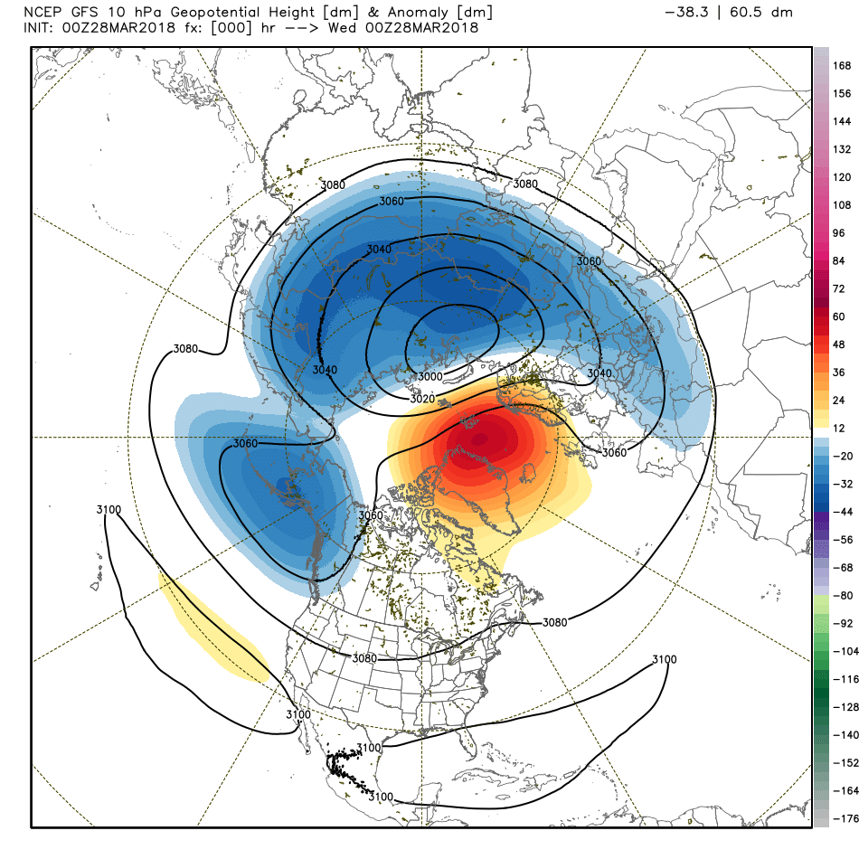
The Polar Vortex often remains undisturbed over arctic in winter and early Spring, driving westerly winds in the layer of the atmosphere below the stratosphere called the troposphere where our weather happens. However, during a SSW, the polar vortex splits into two vortices which push to lower latitudes. The influence of these changes in the stratosphere spreading down into the troposphere after a few weeks of the warming and split which then greatly impacts the flow patterns that bring our weather. This often, like the 2 cold and snowy events this month, leads to high pressure building over Scandinavia and the polar front jet stream tracking much further south over southern Europe, allowing frigid cold air to spread across Europe. The high sometimes building over or drifting towards Greenland or Iceland, bringing very cold air from the northeast or north too.
Over the coming week or so and probably well into the start of April we will likely continue to see the legacy of the SSW still affecting the upper patterns in the troposphere – which drive our weather. The impacts of a SSW on the troposphere can often last a few months. The weather model guidance continues to indicate presence of upper level and surface blocking high in the Greenland area and a cold vortex to northeast over the coming 7 days or so, which will force the polar front jet stream on a more southerly track than usual across the North Atlantic and to the south of the British Isles much of the time.
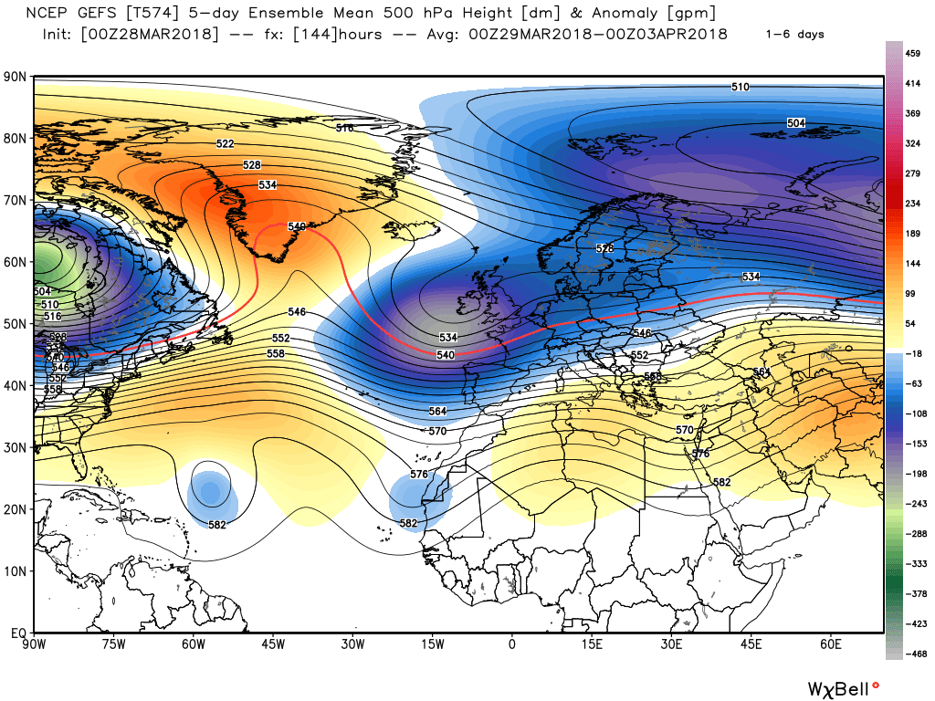
Credit: weatherbell.com
Jet stream to the south of the UK over the coming days, with slow moving lows to the north affecting the UK and cold air across northern areas.
With the stronger steering winds of the jet stream to the south of the UK - this means that we will see slow-moving low pressure systems drift across the British Isles from the Atlantic. The northern flank of these low pressure systems will mark the boundary cold air to the north draining from the cold vortex to the northeast and mild air to the south, with milder air trying push up from to the south ahead of the lows moving in and cold air to the north trying to pull down behind these lows moving on east.
Colder air across the north and milder air across the south trying to win out across the UK over coming days
So we will see the boundary of cold and mild air ripple north and south over the coming days with these passing systems. The weather models haven’t been particularly consistent with positioning of this boundary over the Easter Weekend and into next week, with chopping and changing in position quite a marked thermal boundary over the UK early next week ahead of low pressure either to the west or southwest, depending which model one looks at and which run of the day. For example, yesterday’s 12z showed highs of 16C for next Tuesday across SE England and East Anglia, this morning’s 00z GFS run shows highs of 3-7C!
Southern areas of Britain will be kept south of the boundary in the milder air for much of the time for the rest of this week, through the Easter Weekend and into next. So lows moving across the UK bringing showers or longer spells rain at times, but as the rain or showers move up across northern Britain north of the boundary over central areas then showers will fall or rain will turn to a wintry mix, with snow over the hills and perhaps to lower levels in heavier bursts. On Monday into Tuesday the models are highlighting the potential of more significant snowfall across central and northern Britain for a time, as rain pushes north into the cold air pushing southwest out of Norway to the north of boundary, but a great deal of uncertainty over this outcome.
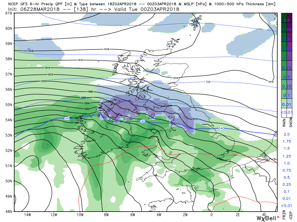
Credit: wxbell.com
We could eventually see a large enough gap between low pressure systems moving east next week to allow colder polar air across northern areas to spread south across all parts, perhaps bringing wintry precipitation across southern areas too. But again, low confidence past early next week, but certainly winter seemingly hasn’t finished with us yet – particularly, but perhaps not exclusively, the north as we head into early April.
In the meantime, expect everything but the kitchen sink thrown at the Uk from the skies as March finishes and April starts, including rain, hail, thunder, snow, strong winds and even elusive spring sunshine.


