


Remaining changeable for rest of the week, with low pressure close by, but many dry but cold through Easter Weekend.
The weather has been rather quiet and settled over the last few days, but that is set to change for the rest of the week, as areas of low pressure move in from the Atlantic, bringing rain at times or showers and also dragging in colder air, which will turn showers wintry in the north. The Easter Weekend is looking drier, with some sunshine, but it will be on the cold side, with a risk of overnight frosts where skies clear.
For now, the first of the lows moving in from the Atlantic this week will move in across northern Britain through today, the frontal system associated with this low has brought rain east bringing a wet night across many areas, with snow across higher ground in the north.
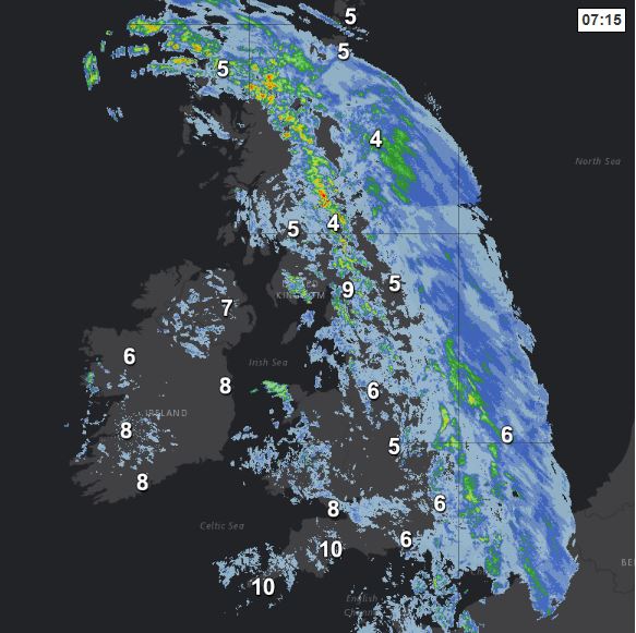
The wettest weather for the morning commute or school run will be across eastern Scotland and eastern England, the rain in the east, locally heavy, will eventually clear this morning, though will linger across northern Scotland. Following will be brighter skies but also some blustery showers, already across western areas, the breezy with sunshine and showers theme continuing through the afternoon for most, but staying wet across the north of Scotland, with hill snow.
Feeling cold across NE Scotland, where there will be a strong southeasterly wind off a cold North Sea – with temperature reaching only 4-5C here. Elsewhere across the north – temperatures reaching 7-9C, across the south – reaching 9-13C.
Persistent rain lingering across the Northern Isles and showers across the northwest tonight, otherwise, many areas dry with clear spells and just a few well scattered showers, a touch of frost developing in some rural areas, temperatures in towns and cities generally dropping to 3-6C, so a chilly night. Cloud and rain spreading in across in across SW England and south Wales by dawn though.
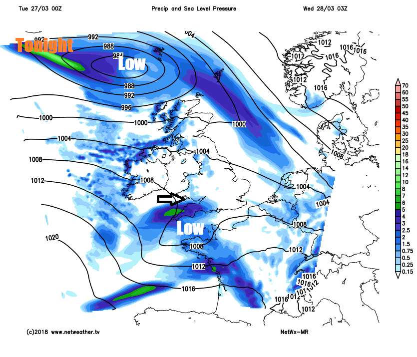
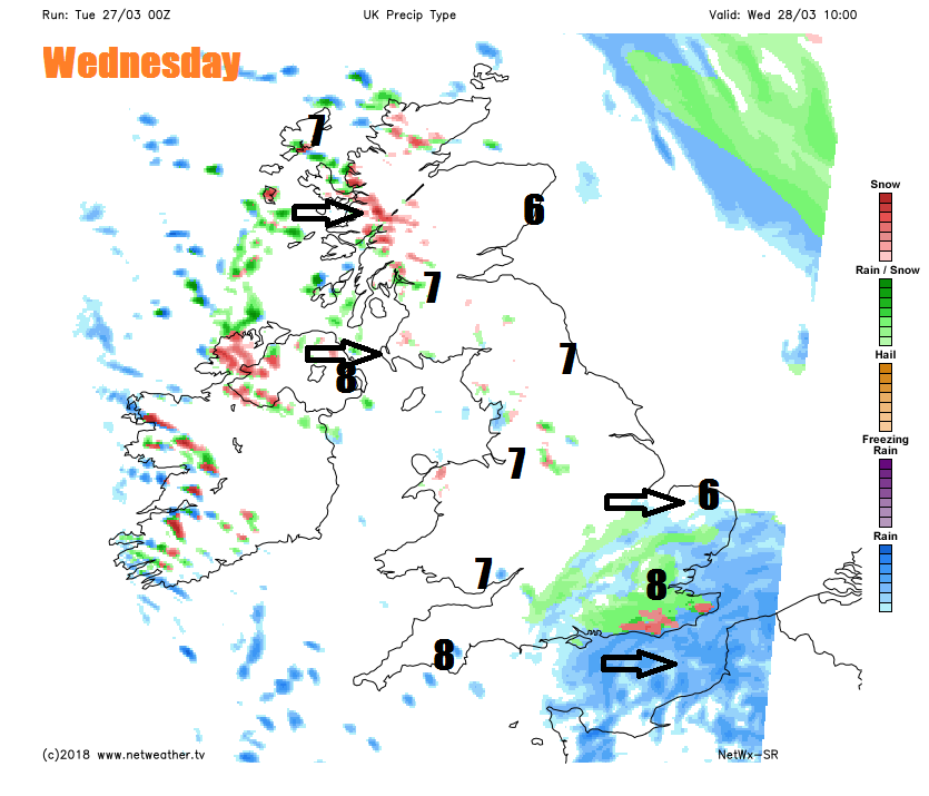
A dry, bright or sunny but chilly start for many on Wednesday. However, rain already across the southwest to start the day, heralds the next low moving across the south this time and spreading rain eastward across south Wales, southern England, The Midlands and East Anglia through the morning. With colder air undercutting from the northwest through the day, perhaps rain turning to sleet lower levels or snow over higher ground too. Rain, sleet and hill snow clearing England through the afternoon, followed by scattered showers, which will be wintry over higher ground. Scotland, northern England and N. Ireland seeing sunshine and wintry showers. Colder than of late, temperatures reaching 6-8C generally.
Then Thursday sees another area of low pressure drift in across SW Britain, bringing increasing risk of showers, locally heavy with hail and the odd rumble of thunder, northeast across much of England and Wales. Scotland, the far north of England along with N. Ireland look like escaping most the showers, just a few well scattered and perhaps wintry, with many staying largely dry and sunny up here. Cold across the north still, with temperatures reaching 5-8C, but in the south, temperatures creeping up into double figures and reaching 10-13C.
Good Friday perhaps seeing fewer showers and brighter across England and Wales, though thicker cloud may bring some patchy rain to the far south, Scotland and N. Ireland mostly dry and bright too, though a few wintry showers likely for northern Scotland. Risk of frost developing Friday night.
The Easter Weekend is looking dry on the whole, with some bright or sunny spells, but on the cold side, as we import colder air from the north and northeast.
There may be some cloud and rain across the far south and a risk of sleet and snow across northern Scotland followed by wintry showers on Sunday. A risk of overnight frost where skies clear.


