After blizzards overnight in the SW, further snow today, but cold retreating north this weekend.
The army has been called in to rescue hundreds of drivers that remain stuck in their cars after heavy snow brought roads a standstill overnight, also passengers were trapped overnight on a train in Dorset which broke down in the snow. Storm Emma moved up across the Bay of Biscay overnight, bringing heavy snow and strong winds through the night across SW England, Wales and Ireland – bringing blizzard conditions, with up to 50cm of snow falling in south Wales.
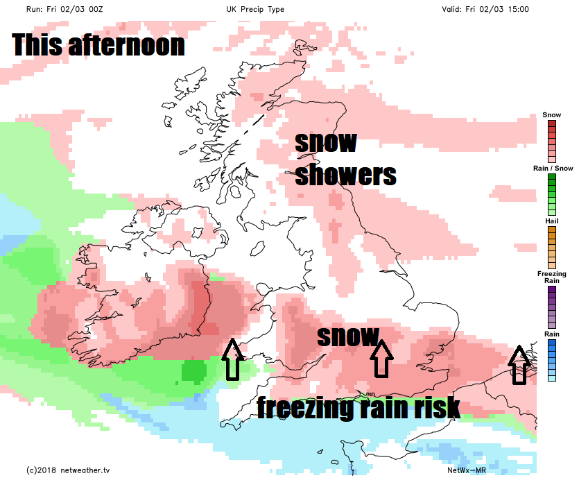
There was also freezing rain along the coasts of southern England, bringing glazing of ice on surfaces, adding to the treacherous conditions. Red and amber warning were issued by the Met Office yesterday for the storm, the red warning has now expired and although the heaviest of the snow has eased away from SW England and Wales for now, it is still snowing and there is a risk of some heavier snow returning this afternoon from the south across much of southern England and Wales.
In more detail for today, the heaviest of the overnight snow across SW England and Wales has moved away over the Irish Sea and will affect Ireland through the morning, where Met Eireann have a Red Alert in place. There will continue to be snow flurries across SW England, Wales and other parts of southern England through the morning, however, the main issue for now is the continuing strong easterly wind, which is gusting to 40-50mph or more, bringing snow drifts across roads – which may potentially cut-off communities where heavy snow has fallen overnight.
As well as an amber warning in place until 8am this morning across south Wales, SW and south central England – there is an amber warning for snow for northern England, eastern Scotland and Northern Ireland – as further snow showers blow in off the sea here through the day – adding to already significant accumulations in places. Across western Scotland and NW England – it should stay mostly dry and sunny.
Back down south, a rather cloudy picture for the rest of the day for Wales, central and southern England, snow flurries this morning replaced by outbreaks of more persistent and heavier snow in places from the south through the afternoon, giving another 2-5cm in places, perhaps more in a few spots. Risk of rain along the south coast as milder air tries to move in, which falling on frozen surfaces, will bringing slippery conditions.
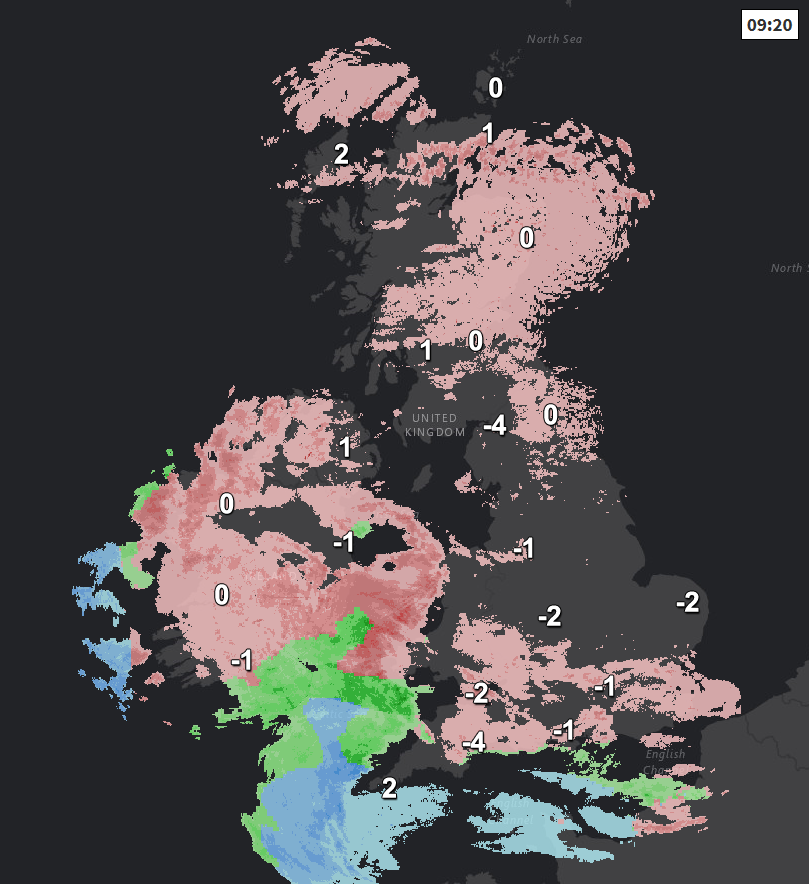
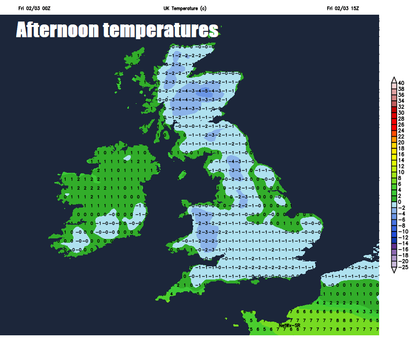
Yesterday saw the coldest March day on record, with lowest maximum temperature of -5.2C in Tredegar in south Wales beating the previous record of -4.6C in Casley, Sutherland on 2nd March 2001. Most areas in Britain were below freezing yesterday, even in London, but temperatures will not be quite as low today, but still struggling to get much above freezing, some places in the north and west perhaps remaining below.
Snow showers continuing to affect eastern Scotland and NE England overnight – drier with clear skies for western Scotland and NW England, further south across England and Wales, outbreaks of sleet and snow, perhaps freezing rain in the south, spreading north through the evening and overnight. Temperatures close to or below freezing overnight, bringing a risk of frost and ice.
.png)
Staying on the cold side across the north this weekend, though not as bitterly cold, but still with snow showers affecting eastern Scotland on Saturday, drier and sunny across western Scotland. Further south across England, Wales and Northern Ireland - generally cloudy with patchy sleet and snow spreading north through the day, though generally light, and snow becoming confined to northern England, north Wales and N. Ireland – tending to turn to sleet or rain across southern England and south Wales – as less cold air arrives from the south, leading to a thaw of lying snow.
Very cold air retreating north this weekend, but remaining unsettled, with snow in the north
Sunday sees temperatures continue to rise across southern Britain, with some rain showers spreading in across southern England and south Wales, drier and brighter across central areas. Still cold across the north, with patchy sleet and snow affecting northern England, Northern Ireland and southern Scotland, snow showers across NE Scotland, while NW Scotland looks to stay mostly dry and sunny.
Staying cold across the far north early next week, with further outbreaks of snow at times for northern Scotland, sleet and hill snow for southern Scotland. For England and Wales, rain showers, perhaps sleet or snow over the hills in the north. Turning mild in the south.