Temperatures on Tuesday up into double figures before Wednesday winds strengthen
January Temperatures
Temperatures reached 14.6C today, Tues 23rd in Exeter. 13.7C in London and W.Yorkshire. That's not what you would expect for January and remembering a few days ago with bitter winds, lying snow and ice, once more the UK weather is chopping and changing.
Average temperatures- January (Met Office data)
S England 7.3C
N.England 6.4C
Wales 6.8C
Northern Ireland 7.0C
Scotland 5.3C
The highest daily maximum in January for the UK is +18.3C, which has occurred a few times, most recently on 26th Jan 2003 in Aberdeenshire and Kincardineshire. In 1982 West Linton in the Scottish Borders only reached a top temperature of -13C by day. imagine that! It was also that January when the lowest UK temperature was reached -27.2C in Braemar.
Two years ago County Londonderry saw it's mildest January night with a minimum of +13.1C. The temperatures some places saw today, that max. is equivalent to the lowest temperature that day in Northern Ireland.
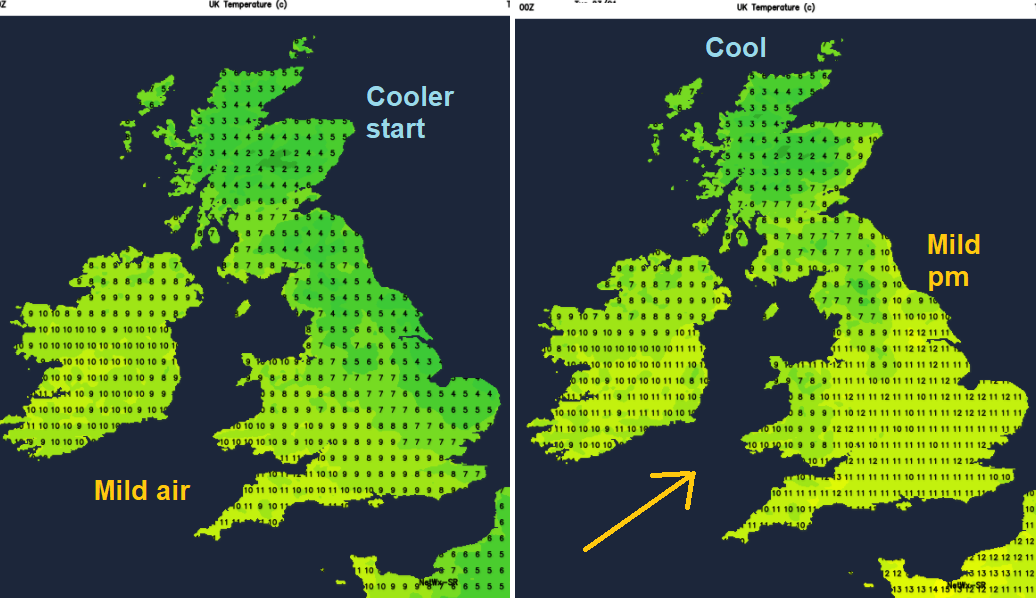
Ignoring the wind for the moment, we have much milder air moving over the UK on Tuesday 23rd, lifting the temperatures into double figures. Around 13C for Chester and Gloucester by 11am. Check your air temperature here. Northern Scotland stayed at 7C.
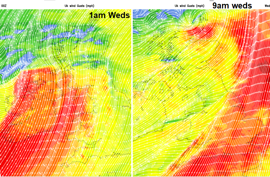
The fresh SW winds are causing high gusts over parts of the UK, around 60mph for higher level routes, so do take care. The wind is making it feel less mild but at least it isn't bitter like when the wind was in the North.
Wednesday winds
As a deepening area of low pressure heads in Tuesday night into Wednesday morning, there will be even stronger SW winds. Gales and gusts of 50 to 70mph are expected. As the frontal bands move through there will be heavy rain and gusts. The main area of potentially severe weather will be on the cold front hitting Wales and western England ready for rush hour and a curl of severe gales with gusts around 70mph for Caithness and Orkney about 9/10am. More details in the Netweather watch, about newly named #Storm Georgina.
Wind Warning for Ireland- Met Eireann
A depression now named Storm Georgina will track to the northwest of the country tonight. Southwest winds will reach mean speeds between 65 and 80 km/h, gusting up to 120 km/h for a time tonight. (75mph) Issued: Tuesday 23 January 2018 14:00
Valid: Wednesday 24 January 2018 00:01 to Wednesday 24 January 2018 05:00
Netweather Watch for strong winds Wednesday