Quiet and cloudy weather on the way out, as strong westerly winds bring colder air and showers, which will fall as snow in the north.
It’s a dry and bright looking picture for Sunday, but with quite a lot of cloud around and the wind will pick up in the west later, heralding a change a foot to start the new week. Wind and rain will move in across the far northwest this afternoon, before spreading southeast across all parts overnight, following on behind for Monday through to Thursday will be brighter but showery conditions, with showers turning increasingly wintry in the north, with a risk of snow, as colder polar air crossing the Atlantic from NE Canada digs in. There is potential for deepening low to cross somewhere over the UK on Thursday, which could bring gales or severe gales and also heavy snow on its northern flank, though exact track not certain for now.
For now, apart from a few scattered showers across Scotland, it’s a dry but cloudy picture this morning for most. There have been some breaks in the cloud though in the west, and this has lead to temperatures to fall close to freezing overnight across parts of SW England with some patchy mist and fog elsewhere. Through the morning we should see some sunny spells develop with these breaks, particularly for Wales and western parts of England, though it could remain dull and misty towards eastern England. Turning windy across the north and west, and through the afternoon a band of rain will creep in across Northern Ireland, northern and western Scotland.
Turning milder across the far west as southerly winds increase, with temperatures reaching 7-9C this afternoon, chillier elsewhere, with temperatures reaching 4-6C.
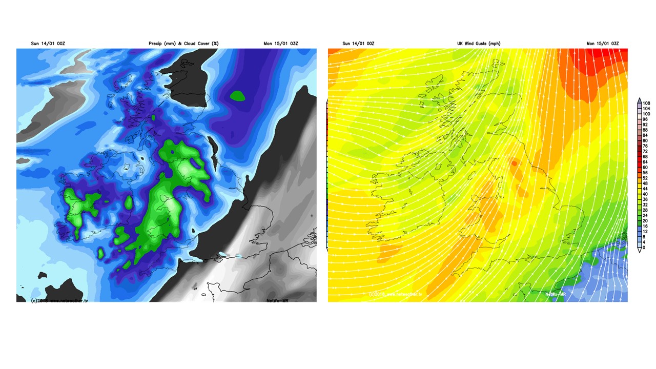
Through this evening, a band of rain and strong winds will continue to spread southeast across Scotland, Northern Ireland and eventually northern England, winds perhaps gusting to 70mph across western Scotland. The wet and windy conditions spreading southeastwards across the rest of the UK overnight into Monday morning, winds gusting to 60mph over western coasts and hills. Dry with clear spells for southern and eastern England may mean it turns cold for a time before the rain arrives and wind picks up later in the night.
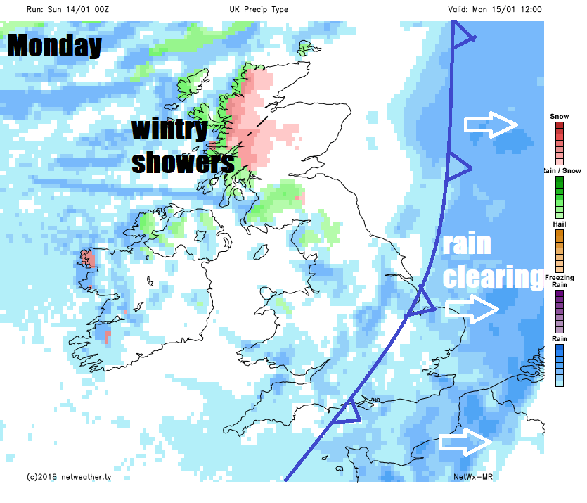
 Monday
A wet and windy start to Monday, with a lot of surface water likely on roads and motorways across England and Wales for the morning commute. Heavy rain and strong gusty winds will slowly clear east across England through the morning, brighter but showery conditions moving in across the west following across most areas by lunchtime. Sunshine and showers for most in the afternoon driven through by a strong westerly wind, turning increasingly to snow across Scotland, with accumulations over higher ground, as colder air digs in. Temperatures reaching 8-10C across south Wales and southern England, but north Wales and northern England temperatures will reach 3-6C at best in the afternoon, as the cold air arrives.
Tuesday brings sunshine and blustery showers again, driven through by a strong but cold westerly wind. Showers falling as sleet and snow across Scotland, Northern Ireland and far north of England, perhaps with hail and thunder too. Further south more likely hail or rain showers with perhaps wintriness over higher ground in the west, risk of thunder near western coasts. Temperatures reaching 3-5C at best from northern England northwards, 6-8C further south.
Then on Wednesday, we continue with the cold westerly flow, with sunny spells and further showers in the north and west, which will be wintry in the north. Thicker cloud and outbreaks of rain arriving later in the day across the west, heralding a deepening low moving off the Atlantic, which looks to bring a spell of heavy rain and gales or even severe gales across England and Wales on Wednesday night, with snow on the northern flank of low, most likely for Scotland.
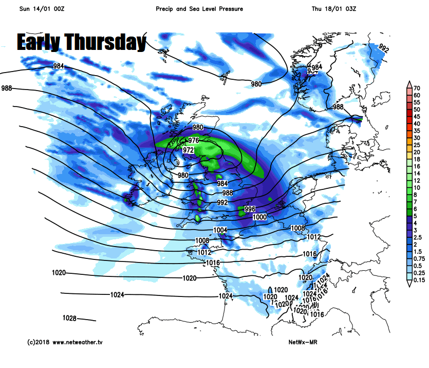
Gales, rain, sleet and snow clearing Thursday morning, as the deep low moves off east over the North Sea, followed to a return of a cold westerly wind which will bring sunny spells and showers which will be mostly across the north and west and will again fall as sleet and snow in the north. Similar on Friday, with sunny spells and showers in the north and west, wintry in the north, eastern areas perhaps mostly dry.