It won't be as misty, foggy or grey by the weekend but with brisk winds and rain from the west. Colder next week with a bit of snow.
There is enough of a wind this morning, stirring the atmosphere that Northern Ireland and Ireland don’t have the thick fog problems seen midweek. The pea-souper has shifted thanks to the brisk S/SE wind. Over Britain, there are lighter winds and again mist and patchy fog about so another murky, grey start for many.
Recently there has been high pressure over northern Europe blocking all the Atlantic weather action. Now as the high centres on the Atlantic states, the UK begins to get more windy and unsettled conditions as weather fronts erode the edges of the high. The breeze over Ireland is the beginnings and there will be stronger winds at the weekend, bands of rain trying to move eastwards and after a successful cold front traversing Britain, a colder new week.
Today, again we have a cloudy grey start but by this afternoon there should be more breaks in the cloud over Britain and brighter even sunny spells. For London and East Anglia, the winds stay light but elsewhere there will be a light to moderate SE wind, fresh around the coasts in the north and west.
Temperatures today will be around 6 to 8C with the SE winds strengthening over N.Ireland.
Weather fronts begin to queue up in a holding pattern to the west of Ireland. The rain will edge over western counties of N.Ireland during the night and the cloud will increase over Britain once more and it will turn damp. Northern Scotland could stay clear and so chilly but for most, it won’t be a cold night.
Saturday will be more breezy with strong winds for western coasts of Britain and still over N.Ireland and the Isle of Man. The band of rain will bring a wet but mild start to Northern Ireland and western fringes of Britain with more cloud and grey skies ahead of it. There will be some breaks, brighter skies and sunshine in the far north. The frontal band edges eastwards but also feed northwards, so it will be pretty wet for western areas and will remain dry over eastern England.
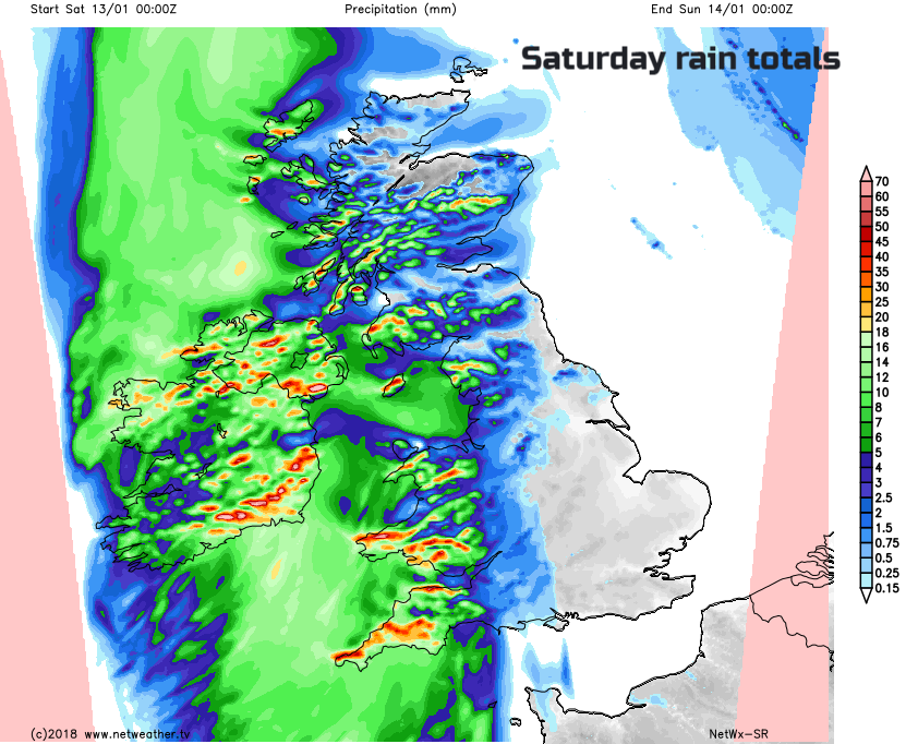
Temperatures remain around 7C although they will pop up to 9 or 10C for a time in Ulster between the fronts. It will feel quite miserable in the wind and rain for Wales and SW England, also for NW England and W. Scotland during the afternoon.
Everything fades a bit by Saturday night; the winds ease down, the rain becomes more patchy but it stays grey and damp with strong S winds for the far NE of Scotland.
This weather system falters in its attempt to move over the UK, but the next one should be more successful to end the weekend.
Sunday
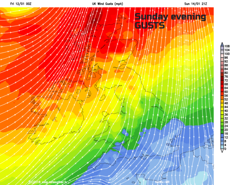
Another mixed start but with light winds away from the far north. It will be cool with patchy frost away from the decaying band of frontal cloud and dampness. There will be fine, bright evening sunny weather about on Sunday until an active weather system swings in from the NW. This will bring heavy rain, strong winds and gusts over 60mph for western Scotland, higher by Sunday evening for the far NW. There could be flooding issues for western Scotland due to the heavy rain and melting snow.
That band of rain and winds moves SE overnight, over England on Monday. Behind this, is colder air and strong westerly winds. Next week looks colder, especially in the wind with wintry showers whistling in from the west. There will be snow, mainly for NW hills but flurries and dustings for other western parts of the UK.
More about next week's cold air and snow showers