A cold start to the week as many people head back to work, but milder temperatures are on the way over the next few days.
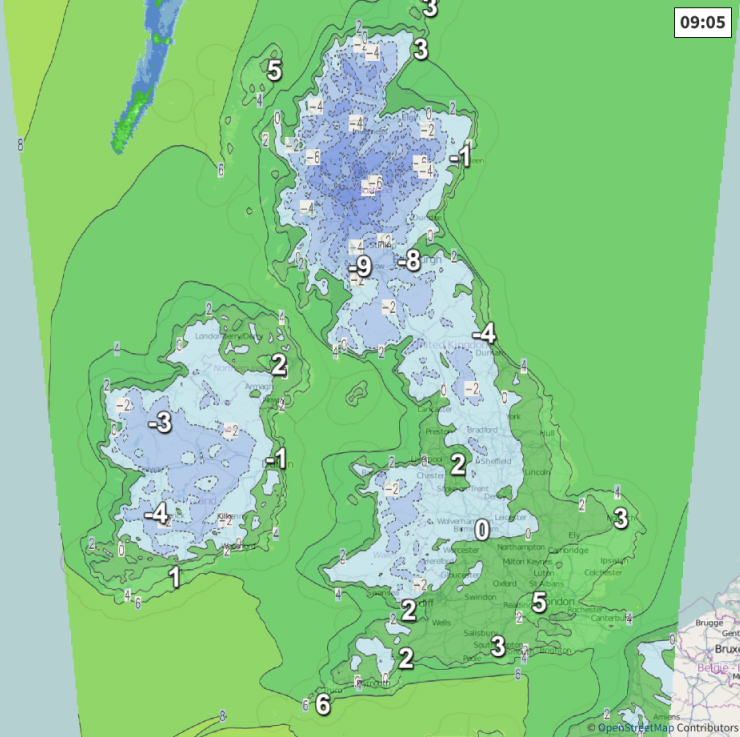
There's a widespread frost away from the South this morning, with temperatures first thing in the Central Lowlands as low as -9C around Glasgow airport. The cold snap isn't expected to last, however, with less cold air and the eventually milder weather is working its way initially from the South and then from the West over the next few days.
For most, it's a fine start but a frosty one, with a good deal of sunshine likely through the day across most of northern England, Scotland and Northern Ireland, spoiled only in the West by upper cloud. It's also a fine, frosty start over North Wales and the North Midlands, but here it'll cloud over from the South making it murky by or during the afternoon, with cloud perhaps moving as far North as South Yorkshire and Manchester by dusk. Remaining areas already have cloud, that'll persist through the day. This is giving a little drizzle in places, but here, temperatures to begin with are just above freezing.
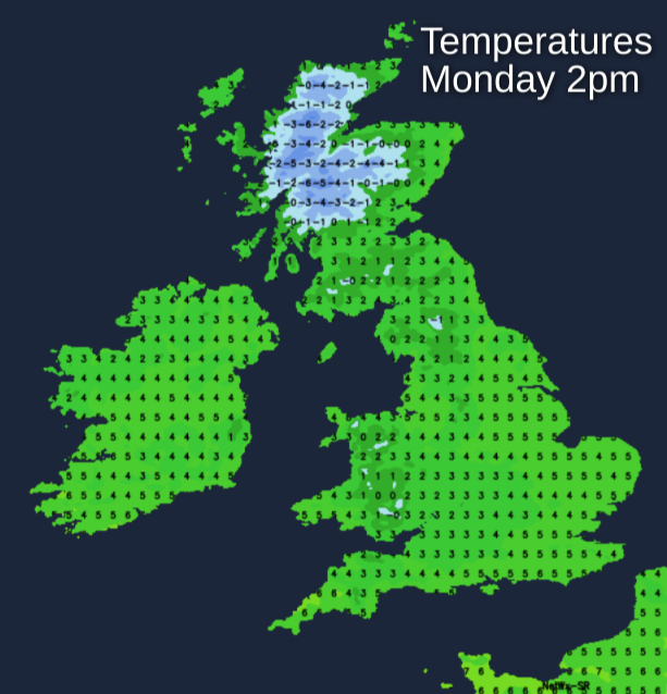
A raw South Easterly breeze over Scotland and Northern Ireland will be mostly light, but somewhat fresher in the West. Across England and Wales, a cold East or North Easterly wind will be more noticeable. As a result, temperatures get no higher than 2 to 4C in the North and 6 or 7C in the South, with a milder 8 or 9C possible towards Cornwall and South facing coasts of Devon.
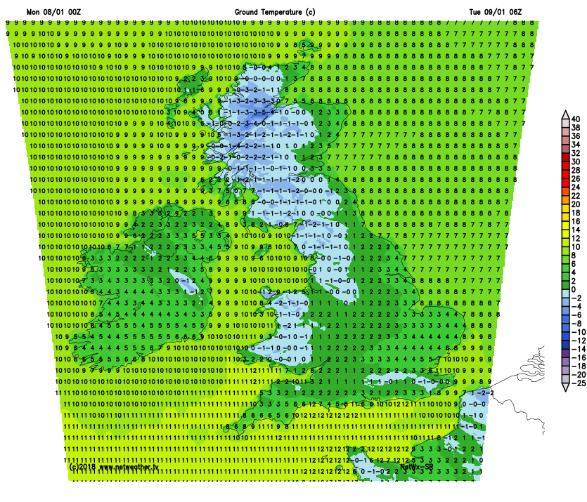
Much of Scotland will have another very cold and frosty night. The far North of England will also have a frost this evening before cloud moves in, this spreading to Dumfries, Lothian and The Borders towards morning. Elsewhere cloud will give a little drizzle in places, with snow grains likely on hills. It'll also turn misty in places with patchy fog.
A mostly light or moderate East or South Easterly wind will continue to feel rather raw, but it'll gradually be turning less cold from the South. Nevertheless, the thermometer could fall as low as -7C in some sheltered Scottish glens, but under the cloud, temperatures will mostly be between 2 and 4C and 5 to 7C towards the South West where it'll be turning increasingly milder.
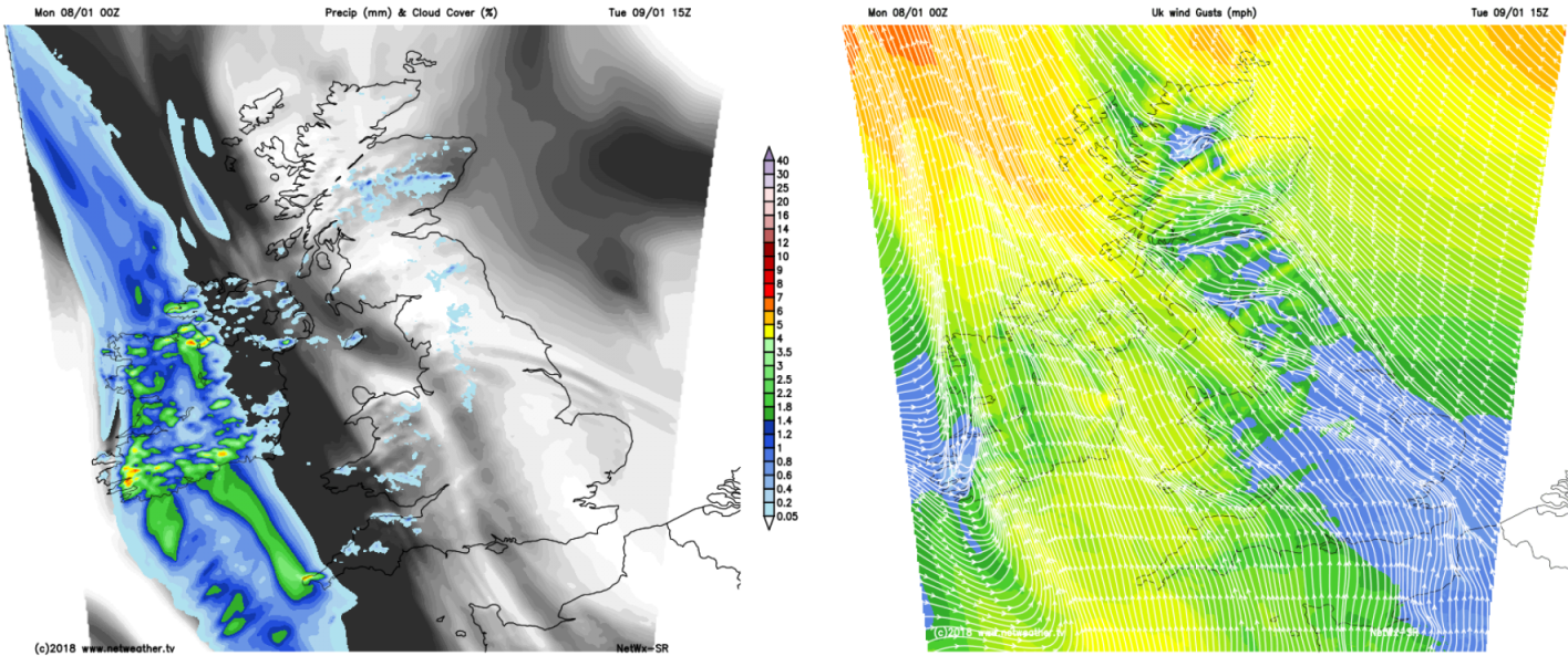
 After another very cold and frosty start over the North of Scotland, most places have a good deal of cloud on Tuesday, making it misty and rather murky. There'll be patches of mostly hill fog, but apart from a little drizzle here and there it'll be mainly dry. As pressure falls, however, there'll be an increasingly unsettled trend through the day with showers likely later, mostly over Northern Ireland, the South West and the West and South of Wales.
The South Easterly wind will become quite fresh across Northern Ireland and over exposed parts of the South West for a while but will be somewhat lighter elsewhere. After a frost over northern Scotland at first temperatures rise slowly, to reach 3 to 5C over Scotland, 6 or 7C fairly generally over England and 8 to 10C across Northern Ireland, South Wales and the South West.
Northern Ireland and the South West may see broken skies moving in later, but for most, it'll be a damp, misty evening and night with patches of hill and coastal fog. There'll also be some rain or showers locally heavy, but with drier intervals as well especially in the East. A South Easterly breeze will veer South to South West in the West, introducing much milder air to these parts. Temperature wise though there'll be something of a West/East split, with the thermometer falling no lower than 7 to 9C towards the South West and 3 to 5C in the East.