


Cold & sunny Sunday, then turning less cold and cloudier before rain mid-week, then turning drier again.

High pressure across northern Britain today will ensure most areas stay dry, bright and cold, particularly across Scotland, where temperatures will stay close to freezing. A cold and strong northeasterly wind will be a feature across the south over the next days, so although not as cold and frosty as further north, it will feel cold in the wind. Dry conditions will continue into early in the new week, but becoming less cold, as high pressure retreats eastwards to allow the wind to turn southeasterly or southerly. Some rain moving in from the west mid-week, as Atlantic fronts move in, but high pressure fighting back from the east, to bring a dry end to the week.
It’s a very cold to Sunday, with a severe frost in places and some patchy ice as well. Temperatures fell as low as -9.1C at Dalwhinnie and -8.7C at Braemar in the Highlands, across Northern Ireland it’s very cold too, with Castlederg dropping to -6C. Across England and Wales not quite so cold, with temperatures hovering close to or just below freezing, a few degrees above in the south, but enough to bring a ground frost. But at least for most of the UK it will be a dry, sunny and crisp morning.
As we head through the afternoon, not much will change, with most areas enjoying dry, fine and sunny weather, just a few wintry showers clipping the northeast coast of England and perhaps some patchy cloud blowing in across the southeast. Temperatures will struggle though, perhaps staying close to freezing inland across Scotland, even in Glasgow and Edinburgh. Across England, Wales and Northern Ireland temperatures reaching 3-5C at best, with a brisk northeasterly wind across the south making it feel colder than this, perhaps gusting to 35-45mph through the English Channel and south North Sea coasts, lighter winds across the north.
Then this evening and overnight, a frost quickly forming under clear skies over northern, central and western areas, SE England and East Anglia probably staying generally frost-free thanks to a strong northeasterly wind continuing here. A warm front drifting up from France will introduce cloudier skies to southern coastal areas by the end of the night.
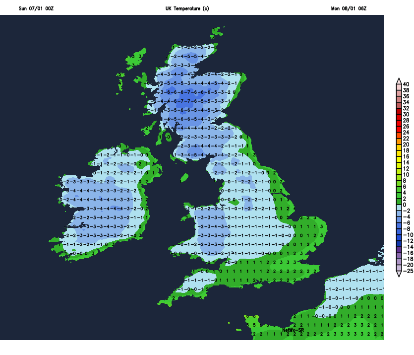
A cold and frosty start across northern, central and western areas, for most a sunny start too, though cloudier and less cold across southern counties of England and this cloud will gradually spread north across England and Wales through Monday, perhaps thick enough to bring some patchy drizzle across southern areas. Much of northern England, Northern Ireland and Scotland staying sunny and dry though. A cold day again across the board, temperatures reaching 3-6C generally. Still a brisk wind across the south.
As we head into Tuesday, high pressure that’s centred over northern UK today continues to drift eastwards into eastern Europe, which will allow less cold air to move in from the south, most places will stay dry, but it will be rather cloudy for many, perhaps thick enough for the odd spot of light rain or drizzle in places. Later in the day, a band of rain and strong southerly winds working in from the Atlantic across the far west. Temperatures reaching 4-7C generally, perhaps 9C across the far SW.
Turning less cold Tuesday as high pressure retreats east, Atlantic making inroads by mid-week ...
Atlantic fronts making inroads on Wednesday, albeit erratically, with generally cloudy skies and outbreaks of rain spreading eastwards, perhaps falling as snow over northern hills, though southern areas will be fairly mild.
However, later in the week, the models suggest high pressure building over Scandinavia putting up a fight against further Atlantic frontal systems trying to move in from the west, so it looks like Thursday and Friday will be mostly dry and bright, though perhaps some rain and hill snow at first across Scotland. Signs that the Atlantic will finally break through next weekend, bringing outbreaks of rain and strengthening winds, though no means certain.


