Cloudy milder conditions remain over much of England and Wales today. The milder air moves from N.Ireland into Scotland tonight but a real chill will spread SE to end the working week. Cold for the weekend
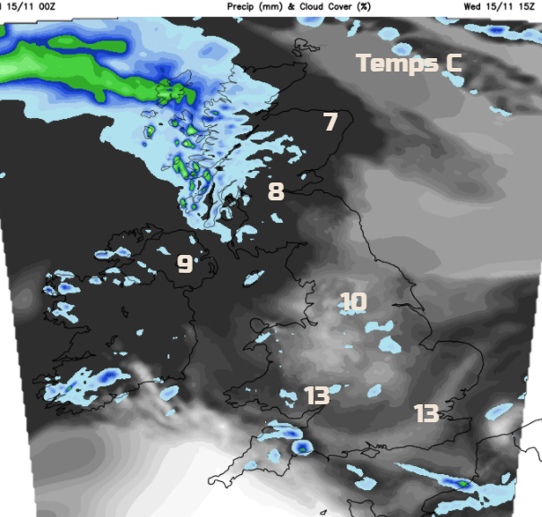
Much of England and Wales has been in milder air and will stay that way today and for part of tomorrow. Temperatures on Tuesday reached over 14C and we could see that again in places. Further north it is a cool start with frost for inland northern Scotland. Milder air will reach right up through Britain tonight, but then colder air will march down from the NW to end the working week.
Differences across the UK with the cloud cover too. Where it is colder it is clear and bright with sunshine. The milder areas have more cloud and it is quite grey and murky. Northern Ireland is a bit mixed with brighter spells coming through. Overall it is dry and calm but some of the low cloud and fog is making it feel damp in England and Wales.
Through the day the winds pick up for Tyrone, Londonderry and Antrim and also western Scotland with a freshening southerly wind. Rain arrives for NW Britain this afternoon on a warm front. Western Scotland particularly the NW Highlands will be in for several wet days.
There will be a few showery bits elsewhere from the thicker cloud, but gaps appear and brighter skies peek through. It will be an okay day today and feel mild for most. Tonight, a low pressure deepens away to the NW and the cold front rain gathers itself. As the low centre heads away to the north, it’s cold front will sweep across the British Isles. So wet tonight for Northern Ireland and Scotland with misty and murky conditions for parts of England and Wales.
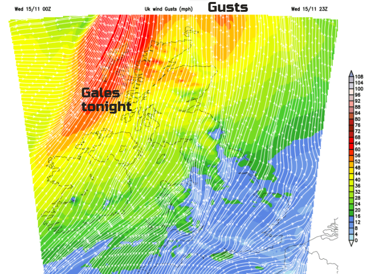
S to SW gales are forecast tonight for western Scotland with gusts around 60mph before midnight. These strong winds move across northern Scotland overnight, veering to a westerly with gales for the Northern Isles by dawn.
Tomorrow
The cold front with rain and brisk winds will be moving SE through Britain on Thursday. So, it could be a wet, cold blustery walk to school or commute to work northern England, southern Scotland and north Wales. Ahead of this band it will be pleasant, with bright spells and still mild. Behind the front it will feel much colder and fresher with clear skies but some sharp showers. In the far NW there could be hail, and sleet and snow for the Highlands. SE Britain could again see 12 or 13C and the frontal band will fade somewhat as it moves through Wales and the Midlands during Thursday. This will just introduce more cloud and light patchy rain by the afternoon.
By Thursday night, most of the UK will be cold and there will be frost about. It stays blustery in the far north. The far south of England will have the frontal cloud and dampness in the evening, but this will clear away in to the Channel
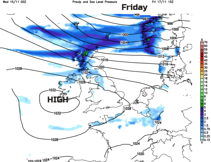
High pressure builds in for Friday, so it should be a fine settled but cool day for most. It will be windier in the north with showery bits including a bit of hill snow continue for western Scotland. It will be quite miserable in the far north with a strong west wind and wet almost sleety showers.

The weekend looks cold, what a surprise. This pattern seems stuck. A cold NW wind which will be raw along North Sea coasts, with widespread frost at night.