After a memorable Monday for weather, Ophelia heads for Norway, but increasingly unsettled through the week, potentially stormy Friday night into Saturday
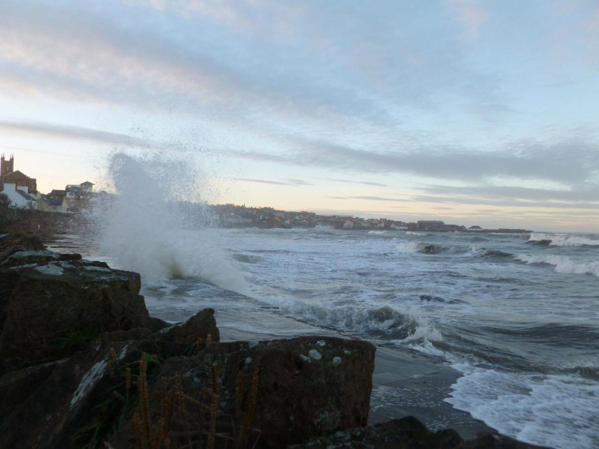
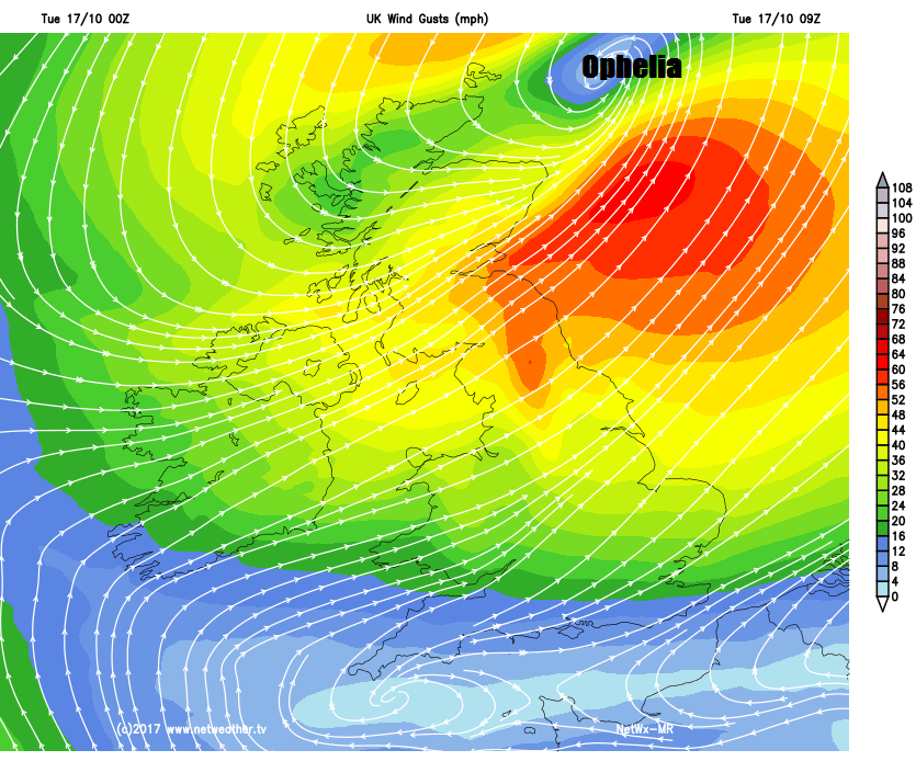
Ex-hurricane Ophelia brought a memorable Monday for different reasons. The powerful storm moved up the western side of Ireland during the day, with hurricane-force winds bringing widespread disruption and damage. A gust of 97mph was recorded at Roches Point at the entrance to Cork Harbour. While the far west of the UK saw violent gusts too, Aberdaron in NW Wales recorded a gust of 89mph. Also, a side effect of Ophelia across the UK was an eerie orange hue to the sky and an orange or red sun, caused by tropical air dragged up from the south containing Sahara dust and smoke particles from wildfires in Iberia. More in my blog here
Ophelia continues to clear away from north of Scotland, however, there is still the risk of damaging and disruptive gusts of wind through this morning across SE Scotland and NE England, with gusts of 50-60mph possible and its windy across the rest of the north with some strong gusts too. The skies are cloudy with outbreaks of rain up here, persistent across the far north of Scotland. Further south across Wales, central, southern and eastern England it’s a drier and brighter picture this morning, with sunny spells, though it will cloud over across southern counties later this morning.
The winds will eventually ease into the afternoon across Scotland and northern England, as Ophelia pulls away towards Scandinavia. But here we will see further showers. Further south will stay mostly dry, bright or sunny, though cloudier across southern England, with the odd shower, with an area of rain moving into the far southwest by the evening.
Feeling fresher than yesterday and temperatures lower, now we’ve lost the warm southerly flow, but closer to what they should be for the time of year. Reaching 11-14C across the north this afternoon, 14-16C in the south. Yesterday saw 23.5C at Manston in east Kent.
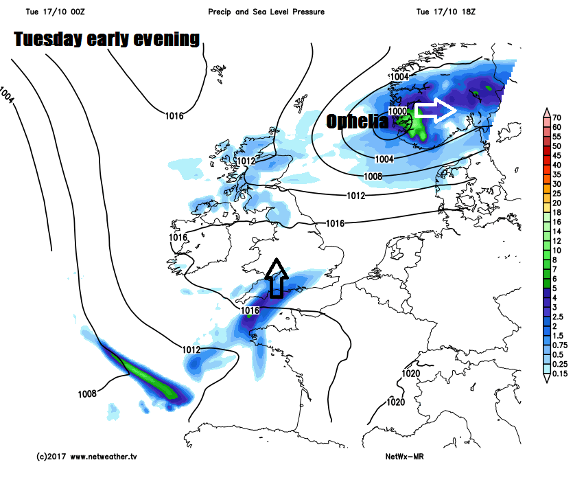
Ophelia heading towards Norway tonight, so wind and showers easing across the north, turning chilly too in the north, with a rural frost possible across northern Scotland. Further south, turning increasingly cloudy and misty from the south across England and Wales, with outbreaks of rain initially across the southwest becoming more widespread.
Patchy rain will gradually clear western areas of England and Wales during Wednesday with drier and brighter conditions moving in from the southwest, though eastern areas probably will stay on the cloudy side with patchy rain or drizzle. Cloudier skies and patchy light rain perhaps reaching southern Scotland and N. Ireland, while northern Scotland stays mostly dry and sunny throughout the day. Temperatures reaching 11-13C in the north, 14-18C in the south.
A rather cloudy and generally unsettled day with showery rain in the east in the morning, while more persistent rain moves in across northern and western areas during the afternoon and evening, turning heavy towards the southwest. Temperatures reaching 13-14C in the north, 15-18C in the south.
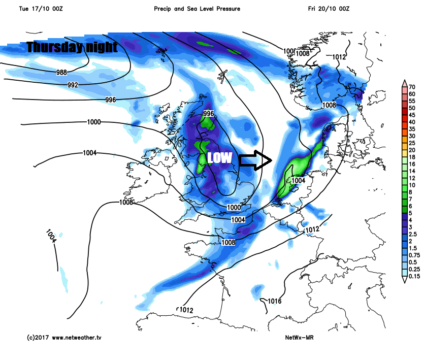
Then on Thursday night, an area of low pressure looks to move into the southwest, bringing heavy across much of England, Wales and southern Scotland and also bringing gales to SW England and through the English Channel. The rain clearing eastern areas first thing on Friday, followed by drier and sunnier conditions from the west across all areas for much of the day.
Then trouble is brewing for the first half of the weekend, as the models indicate another deep depression rolling in off the Atlantic across the UK on Saturday, exact track still uncertain, but a spell of heavy rain and strong winds is likely to sweep all areas, with severe gales possible in places. Sunny spells and blustery showers looks like the theme on Sunday, with a strong westerly wind.