Ophelia has just given up being a hurricane and will affect Ireland, Northern Ireland and parts of Britain today as a powerful, deep low pressure. Extraordinary setup with gales and tropical warmth.
A deep and powerful low pressure will move across Ireland, Northern Ireland and Scotland today bringing stormy conditions and severe gales up through the Irish Sea. It was also 30 years ago today that people were venturing out in SE Britain to the aftermath of the Great ’87 Storm. You’re more likely to be in shorts and T-shirt today in this tropical air. Hurricane Ophelia finally underwent extratropical transition during Sunday evening and is now a post tropical low/extratropical cyclone. It is still marked on the NHC (US national hurricane centre’s) graphics, their last update, by a white circle H. Black circle H is a tropical proper hurricane, the white version is when it has changed but still has the extraordinary winds.
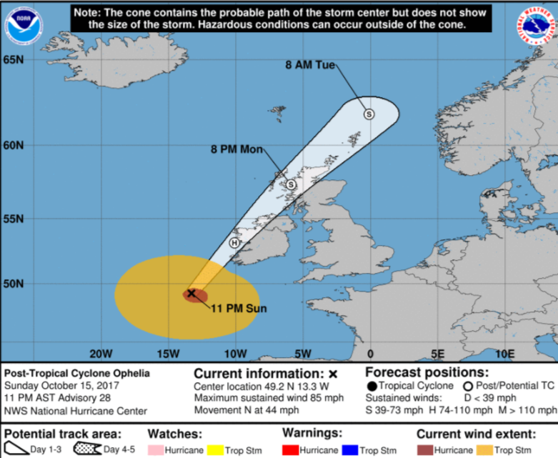
The worst of the winds do not follow the centre of the low track. Generally, they are to the east/SE . This means that Ireland and the Irish Sea will see the worst of the storm today and Northern Ireland, Isle of Man and western Wales later this afternoon and evening.
Warnings
Ireland has a red warning for winds, with bus services and schools cancelled and the army deployed. Northern Ireland, Wales, Isle of Man and SW Scotland have an Amber warning from midday til 11pm.
Met Office Chief Forecaster's assessment
Ex-Ophelia will move northwards across the west of Ireland today bringing some very strong winds to Northern Ireland along with parts of north and west Wales and the extreme southwest of Scotland. Gusts of 55-65 mph are expected widely with 80 mph gusts likely in places. A smaller area of very gusty winds is then likely to run across Northern Ireland from the west with 65-75 mph gusts possible for a short period of time in any one location. Winds are expected to peak across Northern Ireland and north and west Wales this afternoon including this evening's busy travel period and to peak across southwest Scotland this evening.
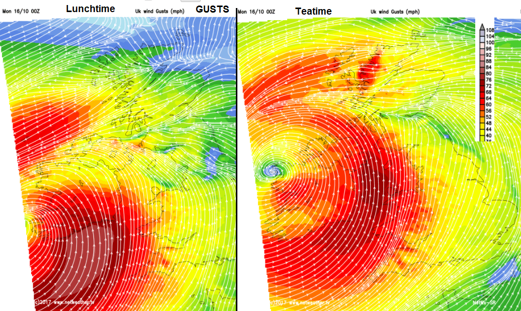
Parts of Britain have a yellow Be Aware warning for wind, today mostly in the west then overnight into Tuesday morning. Overnight the strongest winds will be across a central swathe of the UK and then move across to NE England and eastern Scotland for the Tuesday morning rush.
STORM SURGE: A dangerous storm surge is expected to produce significant coastal flooding near and to the east of where the centre of the post-tropical cyclone makes landfall. Near the coast, the surge will be accompanied by large and destructive waves.
The coastguard has already warned for people stay away from shores and coastlines. The inshore waters forecast for western Wales mentions Violent Storm force 11. Fastnet and Shannon, the sea areas off southern Ireland mentioned Southerly Hurricane Force 12 expected in the shipping forecast with Phenomenal Sea state.
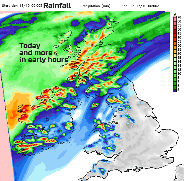
RAINFALL: Ophelia is expected to produce rainfall amounts of 2 to 3 inches (50 mm to 75 mm) with isolated totals near 4 inches (100mm) through Tuesday across western Ireland and Scotland. Across eastern Ireland, rainfall amounts will average around 1 inch (25 mm)or less.
Temperatures
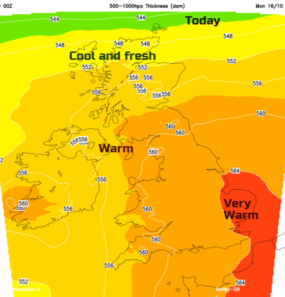
It is very warm. Tropical air has been pumped up ahead of Ophelia and overnight temperatures along the south coast of Britain stayed up I the high teens. The warm front is bringing rain over Scotland and the cold front is already beginning to edge in from the west. So, with lots of cloud and this frontal band on the way, we have to see how high the values reach. 25 or 26C would be possible in this air mass, but there could be too much cloud and not enough time, so 20 to 23C looks more likely. It feels bizarre for mid-October but we do often see a bit of warmth at this time of year. Remember back to 2011, early in October Gravesend, Kent reached 29.9C on the 1st.
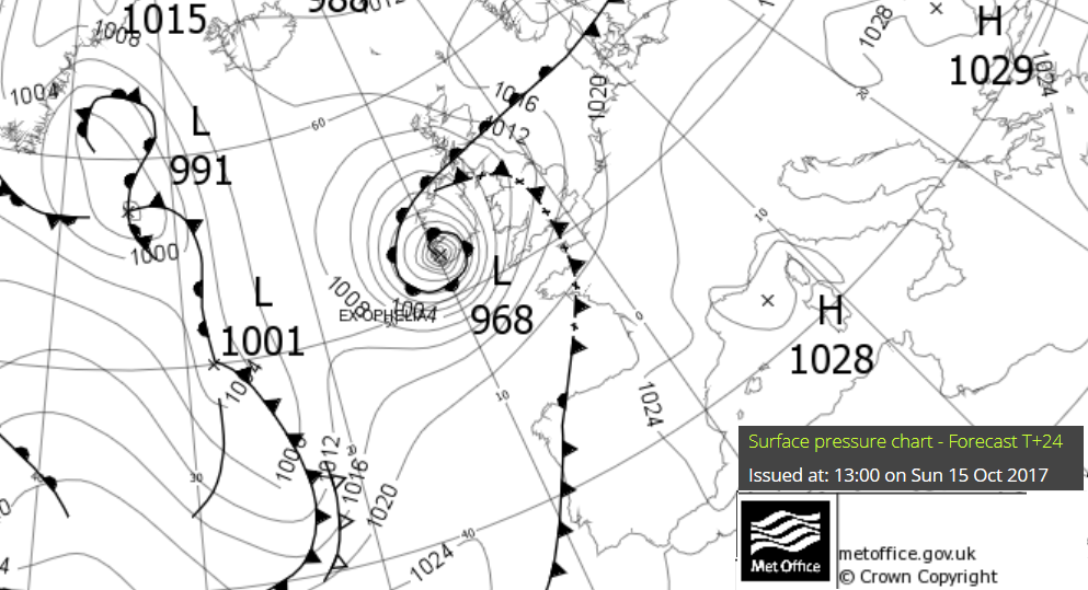
Through this evening much of Ireland, Britani and Northern Ireland will be in strong S to SW winds, still just fresh for SE Britain which is furthest from this storm. A gale force easterly will flow across northern Scotland and then the Northern Isles. The SW winds take hold across the British Isles and Ireland by midnight, still wild in the Irish Sea but hopefully by then without the highest damaging gusts.
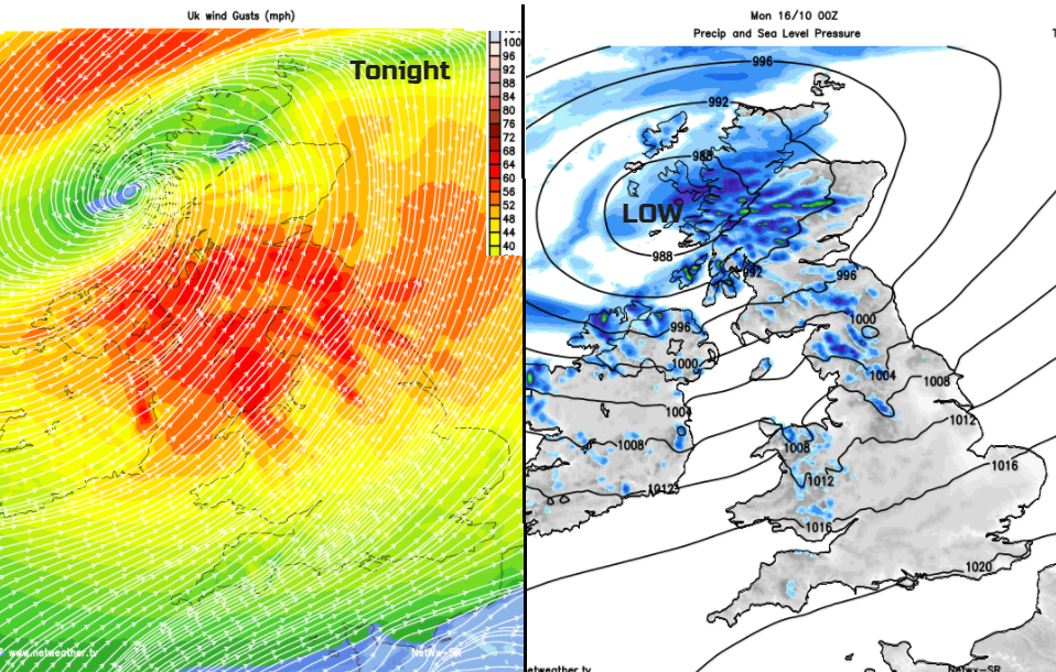
The low then draws away through the Moray Firth, with plenty of lee gustiness for NE England and eastern Scotland, through the Forth early on Tuesday. There ends Ophelia’s visit, what an astonishing meteorological journey. We will await the analysis.
Wind strengths and Sea states explained
Why this is no longer a hurricane
Hurricane Ophelia community forum thread
Warnings: Met Eireann with timings, UK Met Office, Isle of Man