After a chilly night, sunshine and lighter winds should make today feel a little warmer than yesterday for most. Stronger winds and some rain will be back into the north later though, and that'll spread south overnight.
It's not quite full-on ice scraping time yet, but we've had our first cold night of October overnight with temperatures widely dipping away into single figures. Cairngorm Mountain took the honours as the coldest spot, making it down to -0.8c, but even down south in Exeter, the mercury fell away to 3c.
Even after the cold start, for most, it'll feel a bit warmer than yesterday as winds are becoming lighter. But the north and west will see the opposite happening, with winds strengthening, the cloud thickening and rain eventually arriving as an Atlantic system moves in. For the bulk of England and Wales though, it'll stay dry and bright with plenty of sunshine and just a few showers coming a little way inland from coasts exposed to the north or northwest.
.gif)
Through the evening and overnight, the strong wind and outbreaks of rain continue to make their way further south and east, so the weekend isn't going to start with the glorious but chilly sunshine most have had to begin with today.
In fact for the majority, it'll be cloudy with some showers in western parts especially, with the last of the overnight rain continuing to annoy southern England. The patchy rain in the south will eventually clear, then just about all parts will see similar, mostly cloudy weather with some showers or drizzly bits of rain at times. There should be some bright, maybe even sunny moments but they'll be in short supply.
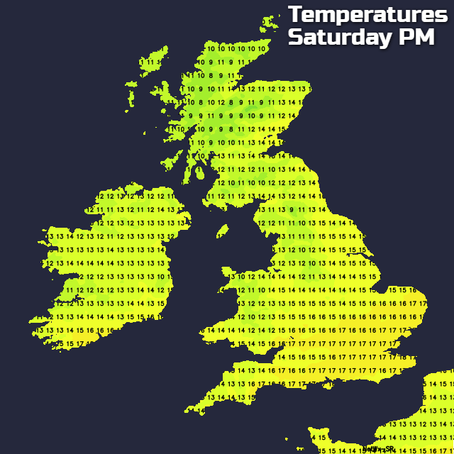
The wind will also be on the fresh side, blowing in from the northwest again, so not an especially warm direction. That said though, with a bit of shelter from it, eastern and central parts should see highs of 17c or so, but cooler elsewhere.
Sunday will see an improvement for some, but stay much the same for others. The further south and east you are, the drier and brighter the weather will be, with the north and west seeing more cloud and some showers again. With light winds and sunny spells, it'll be the southeastern quarter of the country having the warmest temperatures once more, with highs mainly on a par with Saturday.
Michael Fish will be online later with more detail, but looking ahead to next week we're often going to see a similar split in our weather. With the north and west generally seeing the worst of any rain and wind, with the south and east seeing more regular brighter and drier spells. That said, Monday will see some wet weather spreading down from the northwest to eventually reach all parts, with the northwest-southeast split returning again for Tuesday.