
A strong jet stream meandering across the UK over the coming days will bring changeable conditions.
A strong jet stream running in across the UK from the Atlantic for much of this week will keep the weather changeable for many. However, small waves in the jet stream will allow high pressure to briefly build in to bring mostly dry conditions today. But a renewed surge in the jet stream tomorrow will bring a deepening low eastward, bringing a spell of wet and windy weather Wednesday evening and night. Rain will clear the south Thursday morning, then thereafter another wave in the jet will allow high pressure to build back in again to bring a mostly dry, bright and breezy end to the week, before wind and rain returns on Saturday. You get the picture!
Strong meandering jet stream brings changeable weather over the coming days
For now, Scotland, Northern Ireland and northern England start the day on a windy note with gales around northern and western coasts and overnight the far north of Scotland and the Northern Isles saw severe gales with gusts of 55-65mph. The strong westerly wind is blowing in some blustery showers across northwest Britain too, but for many, Tuesday morning will be mostly fine, sunny and breezy after a chilly start.
.png)
High pressure building in from the west will ensure a dry day for most and winds will ease too. We will see scattered showers continue across northwest Britain, but elsewhere there should be some good sunny spells though there will be patchy cloud bubbling up.
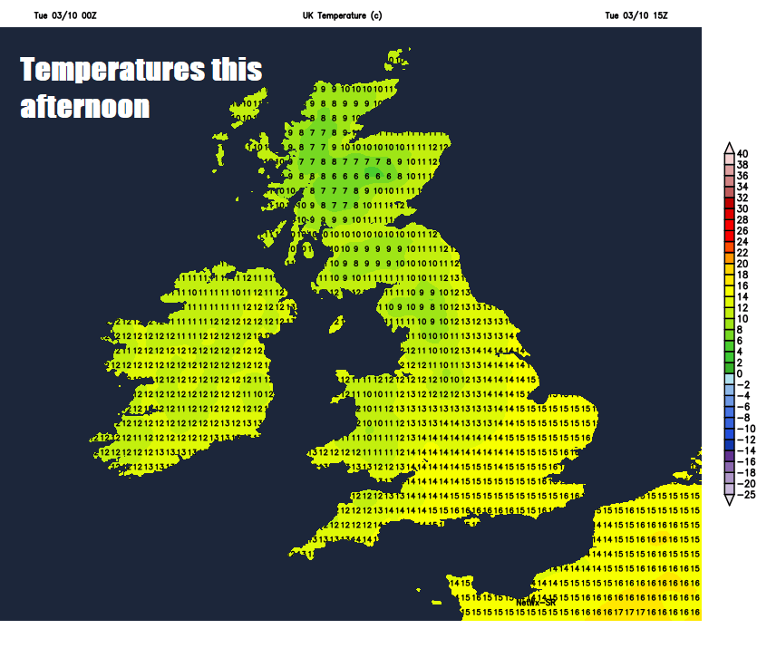
Feeling cooler than recently in the westerly wind, temperatures reaching 13-14C in the north and 15-17C in the south.
As we head through this evening and overnight, it looks like showers continuing in the northwest and merging into a longer spell of locally heavy rain, which will spread southeast across Scotland. Elsewhere, a mostly dry night, cloudier towards the west with clearer spells towards the southeast, turning chilly where skies clear.
A band of rain sinking south across southern Scotland in across Northern Ireland, northern England and north Wales during Wednesday, rain turning heavy from the west by the evening across these areas. Turning drier and brighter with a few showers across northern Scotland, mostly dry and bright across south Wales and the southern half of England, though turning increasingly cloudy. Temperatures reaching 12-14C in the north, 14-16C in the south.
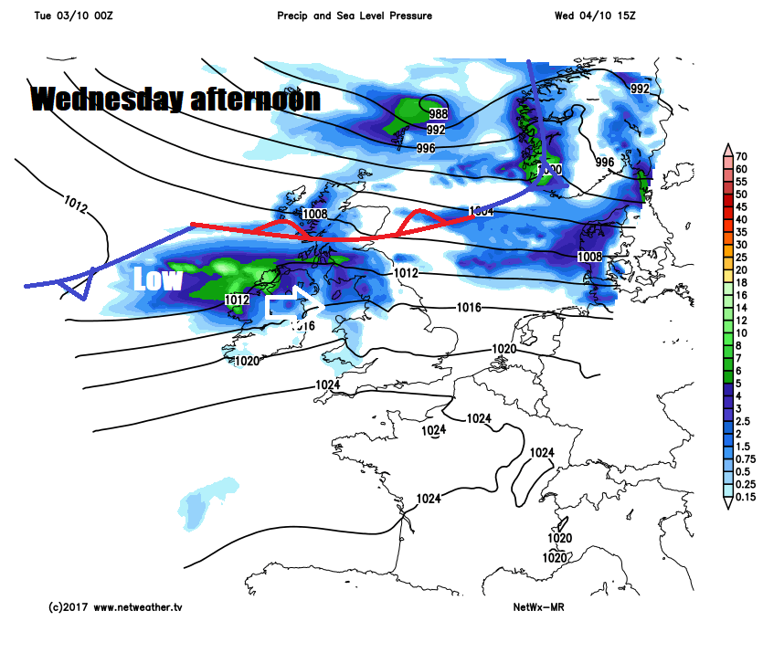
Then a spell of wet and windy weather spreading southeast across England and Wales Wednesday night with a deepening area of low pressure moving east over central Britain. The rain eventually clearing from southern England into the near continent by early Thursday afternoon, clearer conditions following, with most places having a dry and bright but breezy afternoon, though showers likely in the north and northwest.
Friday is looking mostly dry and bright, as high pressure builds in from the west, though cool in the northwesterly breeze. Cloud and rain looks like arriving across the far northwest later on Friday, before stronger winds, cloud and outbreaks of rain spread down across all parts on Saturday. A cool northwesterly wind on Sunday bringing sunny spells and blustery showers is indicated.


