


After a promising start, weather going downhill through the weekend, as wet and windy weather moves in from the Atlantic. However, high pressure builds in from Tuesday, bringing more settled weather.

Don’t be fooled by the fine start this morning for some across the north and east, because it will turn increasingly wet and windy through the weekend, with rain and strengthening winds arriving off the Atlantic later today. The unsettled and windy weather is being stirred up by the remnants of ex-hurricanes Lee and Maria, which will inject some energy into Atlantic low pressure systems affecting the UK this weekend.
Ex-hurricane Maria (bottom left) injects some tropical energy into Atlantic systems this weekend
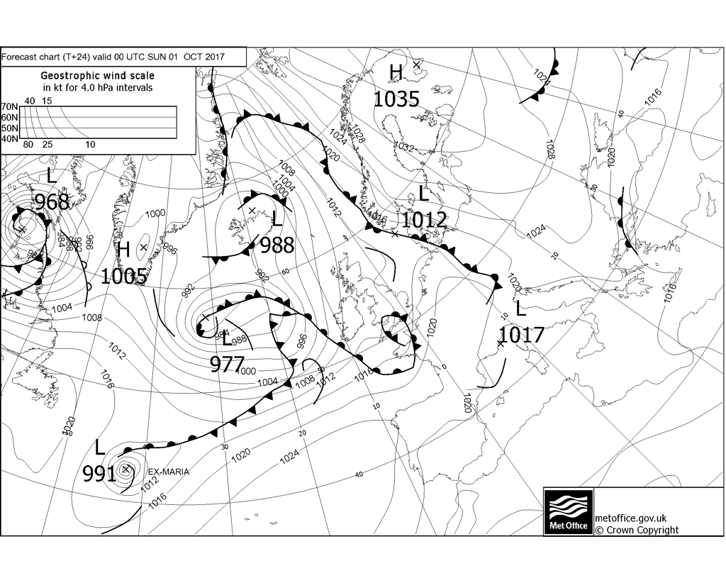
The unsettled, windy and sometimes wet conditions will continue into early next week. However, high pressure should build in for a time mid-week, settling things down, before wind and rain returns to northern Britain to end the week.
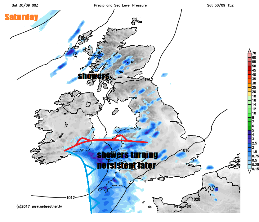
For the rest of the morning and through the afternoon, eastern Scotland will stay mostly dry and sunny, western Scotland, NW England and Northern Ireland seeing sunny spells and showers, some of which will be heavy and perhaps thundery across western coastal areas. Eastern England should become mostly dry and brighter after any early light rain. Southern England and the Midlands will be often cloudy, though with occasional brightness or brief sunny spells, but with further showery outbreaks of rain at times too. Wales and SW England becoming cloudy and seeing showers this morning merge into longer spells of rain this afternoon, winds picking up here too.
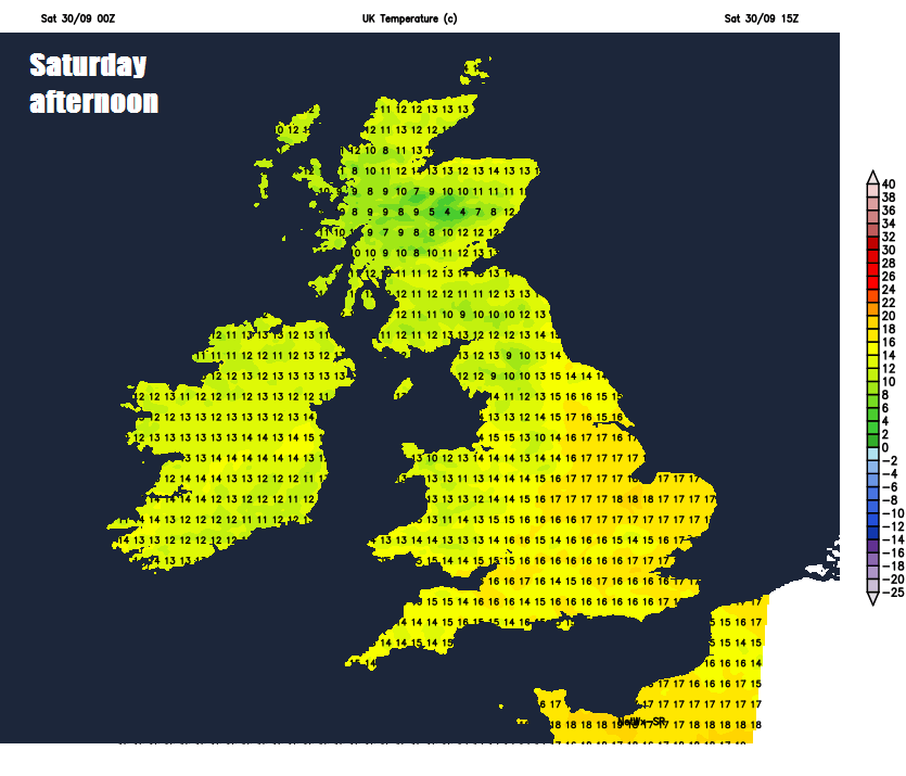
Temperatures today reaching 13-14C across Scotland and N. Ireland, 15-17C across England and Wales.
Cloudy and breezy with a spell of rain spreading east across much of England and Wales overnight. Showers across the northwest tending to fade, then mostly dry with clear spells developing for Scotland and the far north of England, rain spreading in across Ireland, N. Ireland and perhaps far west of Scotland by the end of the night. A mild night, with temperatures falling no lower than 13-15C in the south.
A mild, cloudy and damp start on Sunday. Staying cloudy for many, with rain setting in from the west across northern and western areas during the morning, heavy and persistent across western hills. Outbreaks of rain spreading east across England too but generally lighter towards eastern England. Becoming windy everywhere, with southwesterly gales developing across northern and western areas, with 40-50 mph gusts, perhaps up to 60mph along exposed western coasts and hills. Temperatures reaching 15-17C in the north, 17-19C in the south.
Rain clearing and turning clearer but showery across Scotland, N. Ireland and northern England Sunday night, but also turning even windier as a deepening low clears NE Scotland, with severe gales possible by early Monday, 60-70mph gusts could bring some disruption for the morning commute. Monday windy with sunshine and blustery showers for northern areas while southern areas look to stay mostly cloudy with outbreaks of rain.
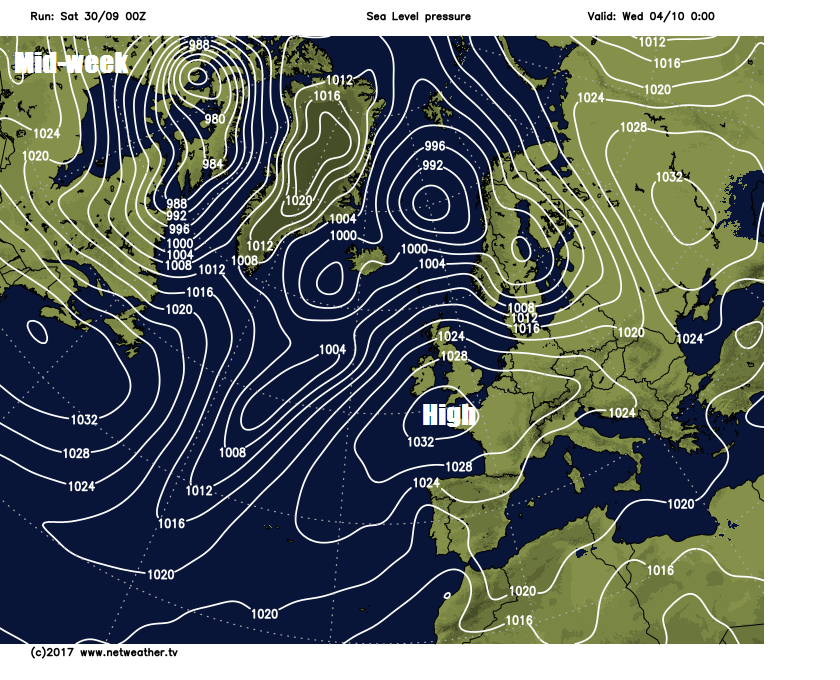
Tuesday and Wednesday see the weather settle down, as high pressure builds from the southwest, with most places dry with sunny spells with temperatures reaching the mid-teens by day, though with clear skies at night it looks to turn chilly with a risk of ground frost in places.
Thursday and Friday looking largely dry and fine too, temperatures perhaps reaching 20C in the southeast, though perhaps turning wet and windy across northern Scotland.


