A changeable and more varied period of weather on the way, but with low confidence in the medium and longer term as an amplified pattern develops
Issued at 1500BST on Tue 19th Sep based on Tue 19th Sep 00Z Model Runs
Key Points
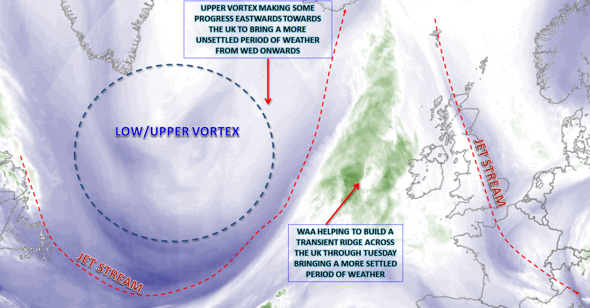
Discussion:
Wed 20th Sep: Into Wednesday and the transient ridge from Tuesday will have declined away to the SE with a primary upper vortex, with associated surface low-pressure features, then approaching from the W in what will be a slowly progressive pattern. With the first ridge still near to SE England that it is across SE England where further dry, bright and pleasantly warm conditions will be. However, across more N and W areas, frontal activity is forecast with spells of rain and showers arriving through the day.
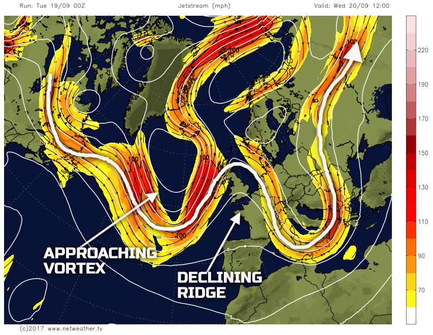
With the pattern particularly amplified then the frontal zones that move into the N and W through the day will be particularly slow-moving, the overall flow across the N Atlantic and into the UK not allowing a quick eastwards progression of the fronts. As a result, a distinct NW and SE split in conditions will develop through the day. Scotland and Ireland, in particular, will be mostly cloudy with outbreaks of rain at times through the day, perhaps locally heavy across south-western facing upslopes too. In contrast, though, many central, southern and south-eastern areas of England will continue to be dominated by a more anticyclonic flow, beneath the declining ridge. As a result, a reasonable day of weather here with some bright or sunny spells and pleasantly warm too, given a developing SW’ly flow and a resultant Tm air mass. The wet weather across Scotland and Ireland, will, eventually, move into N England and Wales through the evening.
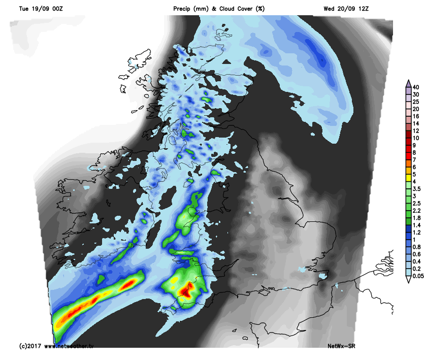
Thu 21st Sep: As we move into Thursday and all the main 00Z GM’s, plus HRES models too, indicate a likely frontal wave development along the slow moving cold front. The continued amplified pattern maintains an environment where the frontal zone will struggle to progress eastwards through the day. While there remain some uncertainties over the details of the frontal wave development, it is likely that SW England, Wales, Midlands and perhaps N England are the primary regions for experiencing some persistent and often heavy rain on Thursday.
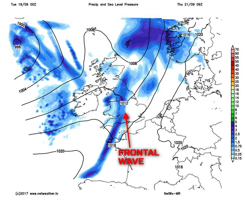
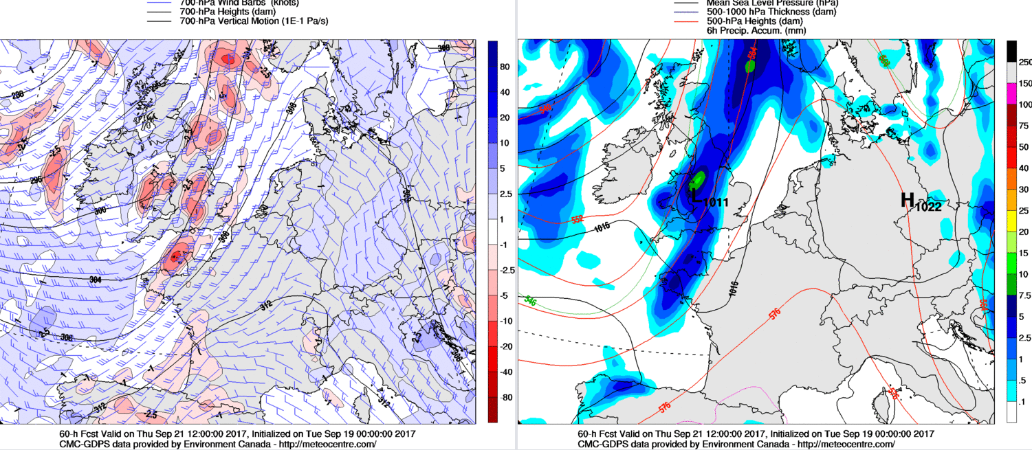
The forecast profiles through the area of frontal wave development do show a lot of moisture through a considerable depth of the atmosphere. With a reasonable plume of theta-w in evidence too, then all the ingredients are present for some locally large rainfall totals. Some orographic enhancement may well come into play as well. While our MR model highlights the frontal wave, it isn’t necessarily capturing the intensity of the precipitation, and a greater amount of moderate or heavy rain should develop through the day. Some of the models even produce an actual surface low pressure along the main CF which runs northwards across parts of the Midlands and N England later in the day. The low could be a focal point as well for some heavy rain, with a marked region of PVA associated with this low-pressure too. The 00Z GEM model highlights this potential, noting the 1011mb low pressure across the N Midlands by 1200Z on Thursday.
Ahead of this region of weather, so across SE England, yet another predominantly dry day is forecast with some bright or sunny spells, despite increasing amounts of cloud. Temperatures may well peak near 20C or 21C across E Anglia and SE England on Thursday before thicker cloud invades from the W through the afternoon and into the evening. Following the frontal wave, so across much of Scotland and Ireland, will be a day of sunshine and well-scattered showers on Thursday. The primary synoptic feature of importance, as a result, is the region of wet weather running NE through the day.
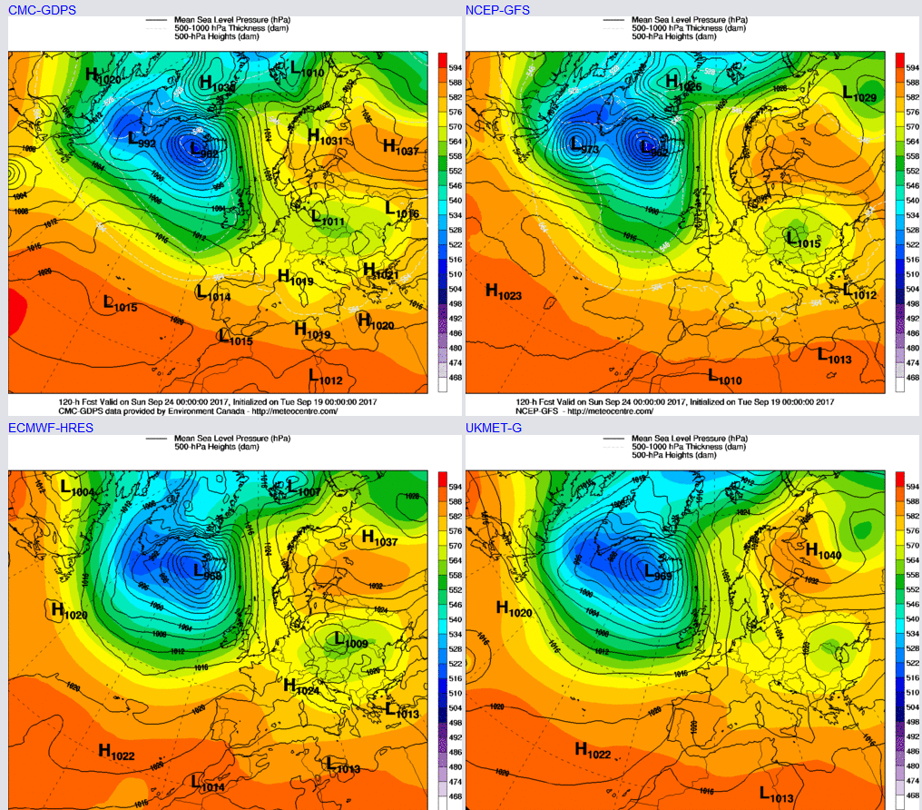
Fri 22nd Sep: We end the working week with the frontal surface zone finally clearing away into the N Sea, and this leaves behind a region of relatively dry and benign conditions across much of England and Wales. However, a shortwave trough will be moving into Scotland and Ireland through the day, perhaps N England and Wales too with further rain or showers as low pressure develop on an SW’ly flow. Trough extension within the N Atlantic too will help to back the flow further later in the day, and this is having implications on the weekend's weather, as pressure rises just to the S and E.
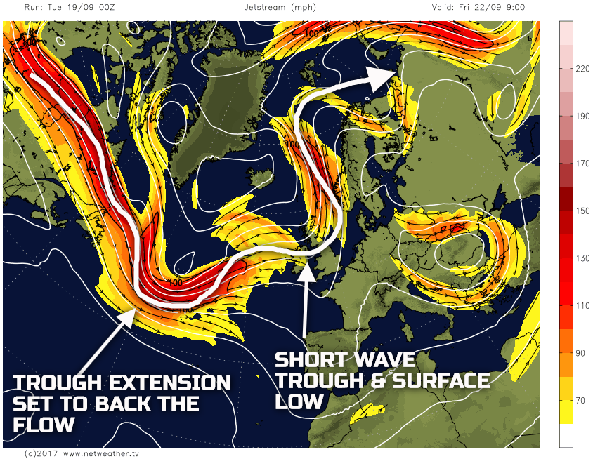
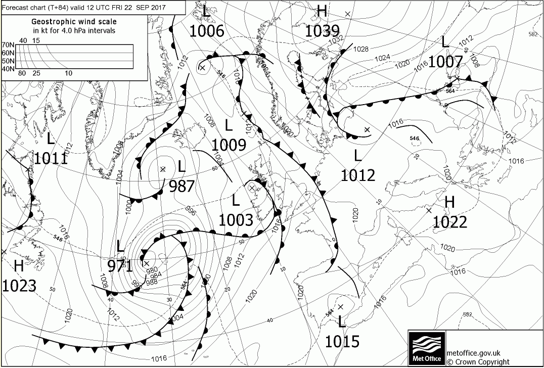
The trough extension within the N Atlantic will lead to a marked region of cyclogenesis. However, from a UK’s point of view is that backing the flow allows for WAA to take place and, overall, amplify the pattern once again. However, through Friday a forward-running low pressure will move into Scotland and Ireland to bring rain and showers here, again perhaps moving down into N England and Wales through the afternoon. However, it is, once again, across SE England where a lot of dry weather will be through the day with some decent spells of sunshine and while cooler than Thursday, it will still be pleasant in the September sun. The 00Z UKMO FAX chart for 12Z Fri 22nd, highlights the developing pattern, noting the 1003mb low moving into the N and W and the clearing front into N Sea.
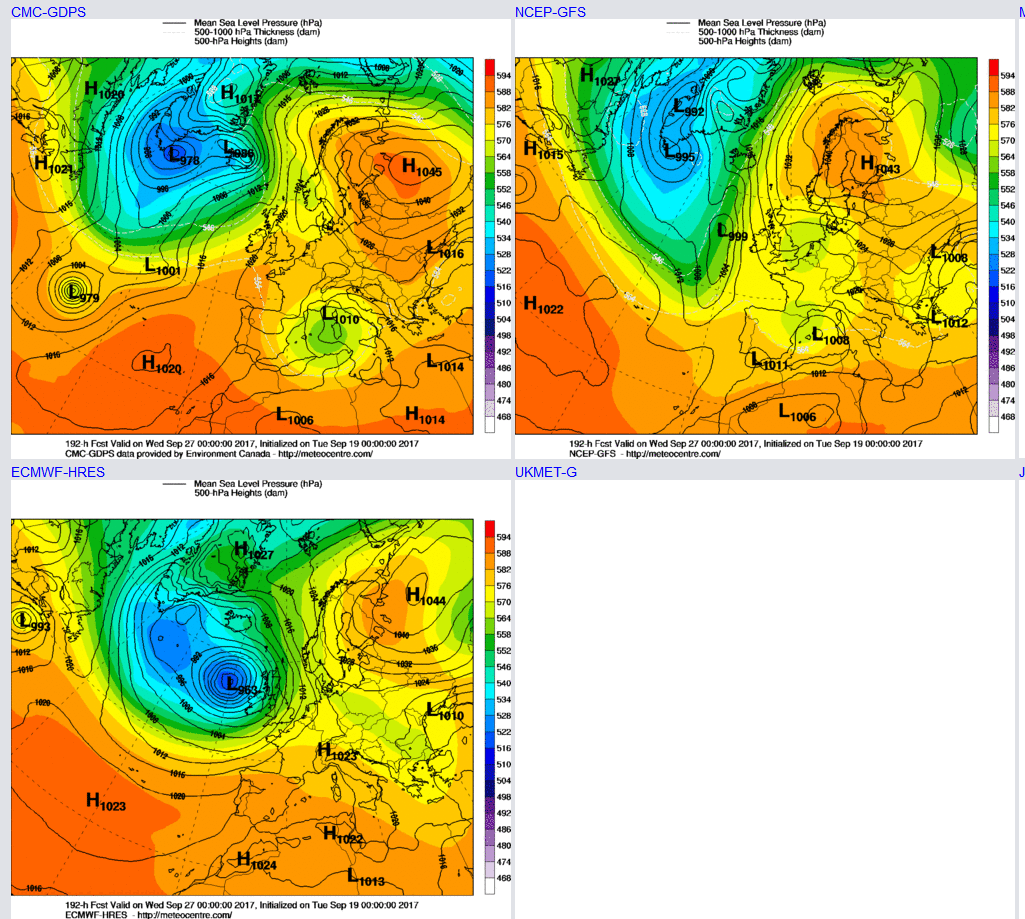
Sat 23rd and Sun 24th Sep: The trough extension within the N Atlantic will have sufficiently amplified the pattern to leave the UK on the edge of a blocking pattern to the E. As a result, much of Saturday is set to be predominantly dry across the British Isles at the moment. However, W Scotland and Ireland will be nearer to the cyclonic developments to the W. As a result; it is across these more extreme western areas of the British Isles were a fresh or strong S, or SW’ly wind is forecast, perhaps with some rain developing through the day as well.
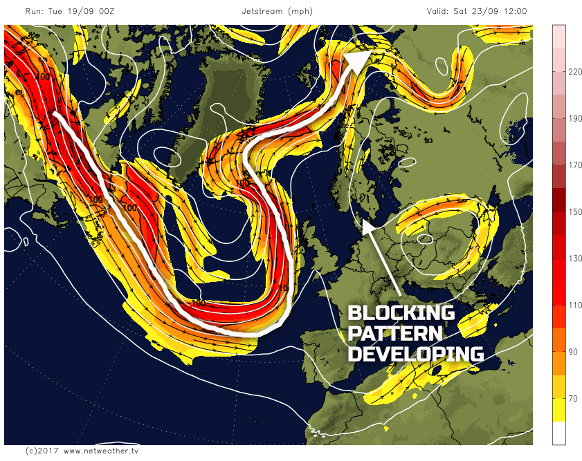
The primary problem with this pattern is that the UK will then be on the border between a distinctly cyclonic pattern within the N Atlantic but with then a blocking pattern to the E or NE. This ‘borderline’ position means there is significant uncertainty over the position or eastward progression of any frontal zones this weekend. At the moment it does look as though a front will progress eastwards into Sunday. However, it will be an increasingly weak feature as it runs up against the blocking pattern to the E. Equally, though, there may well be a more pronounced build of pressure across England and Wales at least, leading to a more settled period of weather from the weekend onwards. The 00Z UKMO, GFS, GEM and ECMWF all place the UK in between these two broader patterns. All that can be said is more N and W areas have a greater risk of being more unsettled this weekend, while further S and E it is likely that further dry weather will prevail.
Medium and Longer Term 25th Sep onwards:
Looking ahead and the impacts of the developing pattern this coming weekend will influence late September and into early October. As a result, low-confidence exists looking ahead to the end of the month. What has been a consistent signal from many of the models is for the blocking high to develop and become a semi-permanent feature over Scandinavia towards the end of September. The primary difference for the UK though is whether the block will keep the UK mainly dry and settled, or, whether, the longwave trough and more cyclonic conditions across the N Atlantic move into the UK domain.
In recent days the GFS and its ENS have been more bullish about bringing the unsettled regime in, whereas the ECMWF has been more blocked. However, and lowering the confidence further, the 00Z runs at least have switched around. The 00Z GFS Det maintains a more blocked E or SE’ly regime, but the 00Z ECMWF brings a far more cyclonic and unsettled pattern. The GEM follows that of the GFS.
It is that time of year too when blocking patterns can become established and depending on the details can still bring some late summer weather, pleasantly warm days, but increasingly chilly nights. Equally, as exampled by the 00Z ECMWF above, if the Atlantic can ‘win out’ then some deep lows bringing autumn gales arrive too. A case of more model runs being required to determine the most likely evolution now for late September and into early October, but either solution is currently possible.


.png?w=350)