


Heatwave 'Lucifer', which has brought record heat to Italy, eases here, but continues for The Balkans and Greece. Meanwhile, heavy rain with a risk of flooding to affect NW Europe.

As you have probably heard in the news, parts of southern Europe have been experiencing a relentless heatwave over recent days, which has sent temperatures soaring to record highs, causing at least two deaths and prompting authorities to issue red weather alerts. Although it is usually hot across southern Europe in August, the past seven days have seen temperatures significantly above average for the time of year, for example, temperatures in much of Italy have been 10C higher than average for the time of year.
Maximum temperatures across southern Europe last Saturday
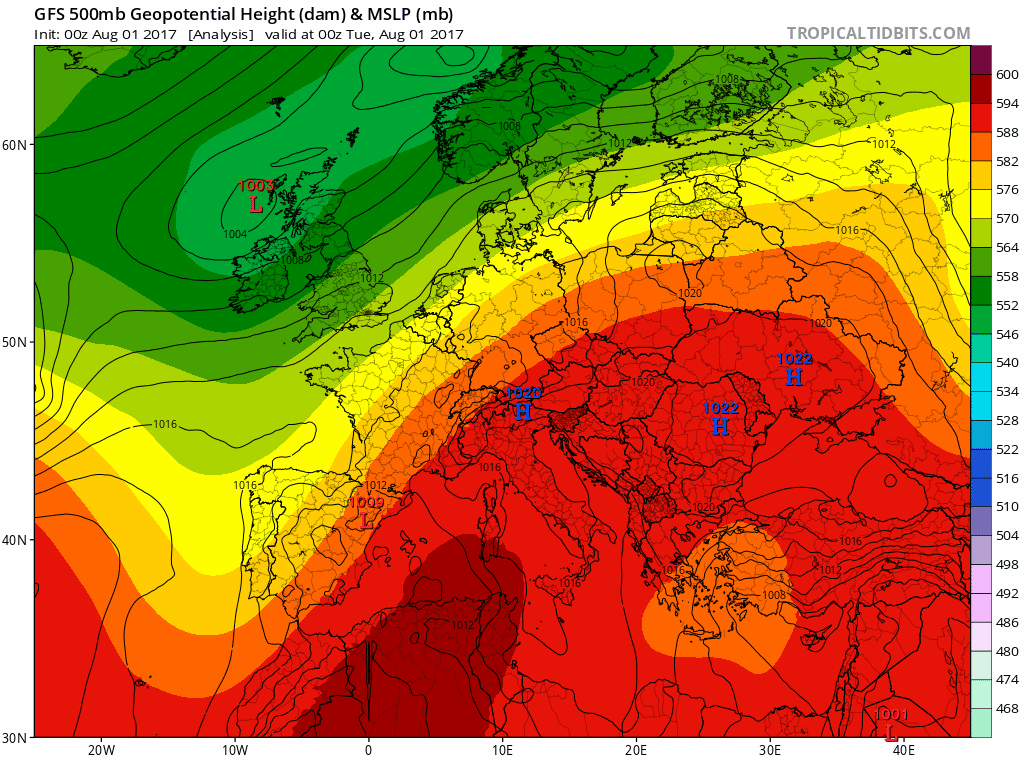
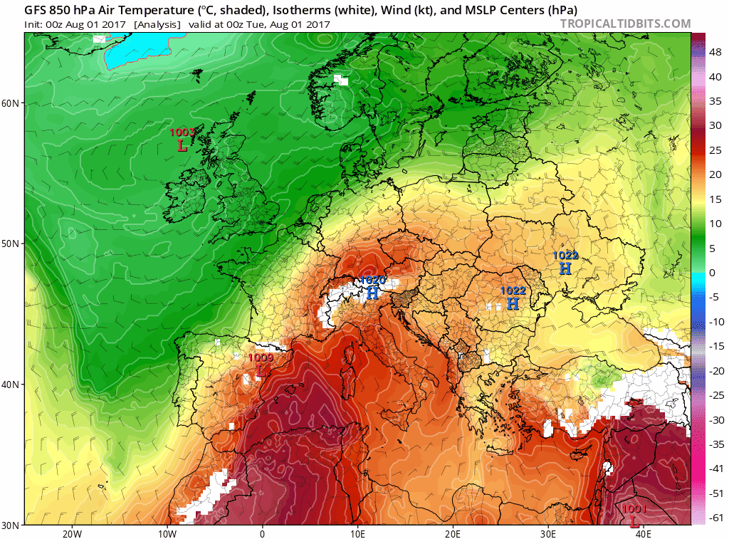
Unusually hot weather, named heatwave 'Lucifer', also spread from southern Europe across Hungary, Romania and as far north as southern Poland. Last Wednesday, temperatures reached 44C in Sardinia, on Thursday Rome reached 43C, while Sicily recorded 42C. On Saturday Cordoba in Spain recorded 44C. As far north as the Czech Republic, 38C was recorded. The extreme heat has built up because of an unusually strong ridge of high pressure and dome of heat extending northeast out of northern Africa, probably a result of an unusually strong ‘zonal’ jet stream further north across northern Europe and deep low pressure over NW Europe strengthening the high pressure ridge to the south, which normally settles over the Mediterranean in summer, but not so strongly.
Strong jet stream and deep low pressure over NW Europe pulling very hot air out of N Africa across southern Europe, causing high temps
As well as the effects on peoples’ health and well-being, the extreme heat has led to dozens of wildfires, damaged cereal and horticultural crops with wine growers in Italy having to harvest their grapes several weeks earlier than usual, apparently never as early, due to the heat. The heat and humidity triggered a huge demand on power and water consumption – with water restrictions in some parts of Italy – where rivers and reservoirs have been drying up after weeks of no rain combined with hot weather. Authorities in some areas issued traffic restrictions and banned work in the open in the hottest part of the day as temperatures reached more than 40 C.
However, the jet stream over northern Europe which has been flat or ‘zonal’ for a while now shows signs of developing some waviness from the west this week. The first of these waves or troughs in the jet will move east into western Europe over the next few days, introducing somewhat cooler conditions from the Atlantic - easing away the extreme heat across Spain, the far south of France and Italy and pushing the extreme heat further east across the Balkans and Greece.
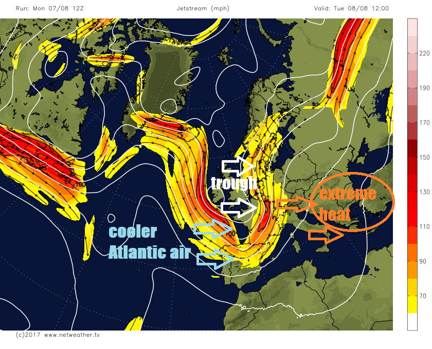
Although temperatures have hit the high 30s and low 40s in a few spots across southern Spain and Italy today, the heat will ease through the week, with temperatures in the low 30s by Friday, which is closer to average. This is thanks to the upper trough arriving across western Europe today and tomorrow moving into central Europe later in the week, drawing in air of Atlantic origin, rather than north African origin across the western and central Mediterranean, with the extreme heat and temperatures as high as 40-42C confined to Greece and Turkey by Friday.
As the upper trough arrives across western Europe, winds will back more southerly – which will allow a surge of very warm and humid air to spread across France and the Alps towards the Low Countries and Germany, at the same time, a thundery area of low pressure will drift north across the near continent to be over the North Sea by noon Wednesday. The combination of cool Atlantic air from the west bumping into this warm and humid air will generate thunderstorms or outbreaks of heavy, locally torrential, rain across France, Switzerland, Germany and Benelux on Tuesday, Wednesday and Thursday, bringing a risk of localised flooding, before the thunderstorms and heavy rain become confined to the Alps and parts of eastern Europe later this week. Parts of southern, central and eastern England will also be affected by heavy and perhaps thundery rain during Tuesday and Wednesday, on the western edge of the same weather system moving north on the near continent.
However, much of southern Europe that has seen extreme heat, dry and parched conditions for several days now, which includes Spain, Italy, the Mediterranean islands and much of the Balkans will continue to see very little or more likely no rain for the rest of the week and probably beyond apart from the parts of the Balkans. So although the heat will ease across the western and central Mediterranean, farmers and water companies may stay concerned.


