As has been common in recent years, we're looking at a fine spell to kick off September. But first, this weekend brings a warm air mass with heat and thundery potential.
As has been common in recent years, we are looking at a fine spell in early September, with high pressure bringing plenty of warm, dry and sunny weather, which may turn hot at times. There will be an interruption early next week with a slow-moving, shallow area of low pressure bringing some showers and potential for thunderstorms, but by midweek it looks probable that high pressure will return. The potential for thundery outbreaks, which have been relatively few and far between so far this year in most parts of the UK, starts this Sunday, although as is often the case in these situations, there will be a strong "hit and miss" element to the storms.
It is unlikely to be as persistently hot as we saw during the early September 2023 heatwave, which set records for the run of consecutive days that exceeded 30C, but temperatures are nonetheless looking set to be well above average during the early part of September 2024.
Saturday has started dry and sunny except in the south-east of England, where there's been rather more cloud. It looks likely to remain relatively cloudy in southern England during the rest of today, with this cloud also spreading into the south-west, but there will still be some brighter intervals. Elsewhere it will remain sunny and moderately warm with temperatures in the low 20s Celsius.
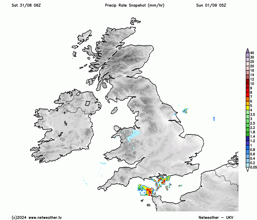
Heat and thunderstorms are forecast for Sunday, when temperatures in eastern England will widely reach the high 20s Celsius, and may touch 30C locally. At present, the Central Southern England, the Midlands and north-east England look the most likely regions to catch a thunderstorm or two during the afternoon and evening, but thunderstorms in this type of setup are unpredictable and hit-and-miss. For example, on 12 August 2024, the forecast models generally had thunderstorms kicking off especially over north-east England, but in the event, they particularly affected parts of Ireland and western Scotland, and kicked off further south, affecting parts of the Midlands and south-east, while north-east England largely missed them. Thus, it can only be said with reasonably high confidence that heavy showers and thunderstorms will develop somewhere in the UK on Sunday.
Showers and thunderstorms will remain a feature of the forecast into Monday, but by Tuesday we can expect just a scattering of mainly light showers, and by Wednesday it looks probable that it will become mainly dry again. Temperatures will fall back close to the seasonal norm by Tuesday and Wednesday of next week, but there are signs that it will probably turn hot again as we head towards next weekend, again with plenty of dry sunny weather but also potential for showers and thunderstorms.
With it being quite late in the season, the heat across continental Europe will be less extreme than we have seen at times earlier in the summer. Nonetheless, temperatures in France will be well above the late August/early September average during this weekend, with temperatures widely hitting the low to mid-30s Celsius, with some regions, particularly inland parts of the south-east, probably reaching the high 30s Celsius.
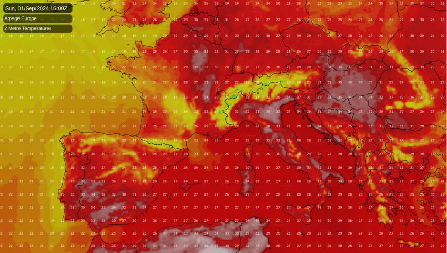
During the next few days, this hot weather will move eastwards and will become especially concentrated over eastern and south-eastern Europe. Maximum temperatures will regularly reach the mid to high 30s Celsius in parts of Italy and the Balkans and into Czechia, eastern Germany and Poland. Minimum temperatures in excess of 20C will make sleeping overnight difficult in buildings that lack air conditioning, particularly in urban areas where the urban heat island is an issue in these situations, with radiation from buildings keeping overnight temperatures higher than in rural areas.
It is this hot weather in eastern Europe that has the potential to make its way westwards towards the British Isles late next week, as the forecast is for winds to become predominantly easterly, at least for a few days. This means that towards the end of next week, eastern coastal parts of England and Scotland may become prone to low cloud coming in off the North Sea, as the hot continental air clashes with relatively cool temperatures in the North Sea. However, away from eastern coastal areas, it looks probable that the weather will often be warm or hot with plenty of sunshine by the back end of next week.
Loading recent activity...