The week starts off mild but it will become windy with further spells of frontal rain from the west or blustery showers passing by.
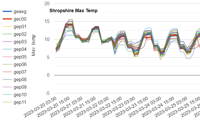
Weather fronts will be piling in from the Atlantic this week. That means a lot of cloud and rain, particularly for western parts of the UK. It will be blustery at times but often mild. Temperatures do decrease slightly through the week. If you are in the wind and rain, it won’t feel that mild but for eastern counties seeing sunny spells temperatures will lift into the teens.
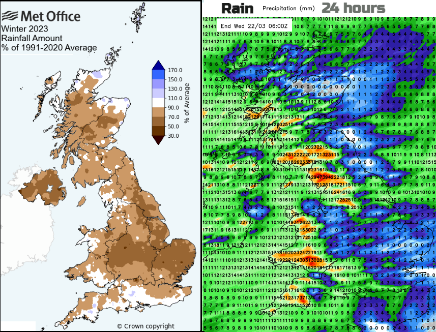
We do need this rain. February was dry overall, the driest February across England since 1993. Monthly rainfall totals in February were below average for all catchments across England, less than 20% of average over most of central and southern England as well as eastern parts of Wales. Winter rains are important for the coming year. We move into astronomical spring; the Equinox is today. There are still drought concerns for the coming summer.
“A particularly dry February has led to lower than normal river flows and groundwater levels for this time of year. Conditions over spring will therefore be key to the risk of water scarcity this summer.” Scotland SEPA
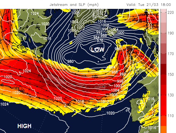
Last month with high pressure over Greenland or the Norwegian Sea, the jet stream had been further south in Europe. That has shifted further north now and although it starts the week with great meanders, a more zonal jet powers across the Atlantic midweek. This will help develop and direct the succession of low pressures coming our way.
A warm sector moves over Britain during Monday allowing temperatures to reach 16C. Overnight a front with heavier rain arrives from the west. Breaks will appear in the cloud and it won’t be as mild.
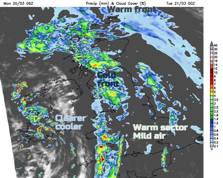
Temperatures on Tuesday will be around 11 to 14C but with a moderate SW wind for England and Wales. There will still be some cloud about with a scattering of showers but brighter breaks in between and warm sunny spells. Some of the showers will be heavy. The winds will be light over Scotland with outbreaks of rain at times. Later in the day the next frontal system will arrive over Ireland with more cloud, rain and a freshening southerly wind.
Tuesday night becomes windy, particularly through the Irish Sea with high lee gusts north of Snowdonia. It will also be very windy for a time for the Western Isles as the winds veer overnight with gales possible. Again mild, cloudy conditions change to clearer, brighter weather but it will feel colder to start with on Wednesday. There will be blustery winds which will be strong and gusty through the Central Belt and then eastern Scotland by lunchtime. Clusters of heavy showers with hail, even wintriness on northern hills will swing by.
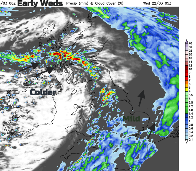
This line of sharp showers pushes north across Scotland as the grey damp weather clears SE England on Wednesday morning. It leaves midweek sunshine but showers breaking out again from the west on a blustery day.
Northern areas will feel a bit more nippy by early Thursday and daytime temperatures will be subdued. A waving front could bring rain over southern Britain as blustery showers continue from the west.
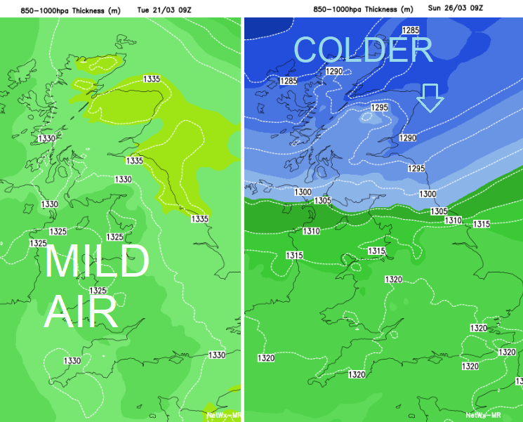
Northern Scotland won’t be as windy but other areas will stay blustery with strong winds for exposed coastal areas around SW and southern England. This unsettled picture continues through the week with signs that colder air may tuck down from the north. It could bring snow, to the Scottish mountains, maybe northern hills with flurries to lower levels. This is a few days away and the hours of daylight are increasing and the ground beginning to warm up, slowly.