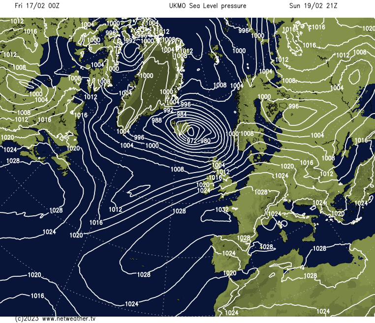
Storm Otto is clearing towards Scandinavia, with the winds now easing back after a wild night. The weekend will see some more blustery conditions, but most of any wetter weather will affect Scotland.
That was a wild night, with Scotland, in particular, catching some very strong winds as storm Otto (named by the Danish Met) moved through. Gusts peaked at 96mph in the Highlands, with many parts of Northern Scotland seeing gusts into the 70's and 80's mph, with Northern England into the high sixties.
It's been enough to cause some disruption, and although winds have started to ease back this morning, it'll be into the afternoon before everywhere is calmer again.
Another small low is going to move in across central and southern Scotland later today and overnight, bringing rain with it for Scotland and Northern England, along with some hill snow for the northern half of Scotland. It'll also serve to pep up the winds again for a time, especially over the high ground of Northern Ireland, Wales, Southern Scotland and Northern England, with gusts of 60mph or so. They should ease down during the first part of Saturday, but it'll stay blustery across much of England and Wales. Scotland will be calmer, though, but with some outbreaks of rain and hill snow continuing at times.
Further south, it'll not be totally dry with some drizzly, light rain in places, but the more organised rain will be limited to southern and central Scotland, along perhaps with the far north of England later on. That area of patchy rain will be along the dividing line between milder and colder temperatures, so for much of Scotland, 4-8c will be about your lot, but head south and the low teens are likely - although with the gusty wind and along with the fact you'll be doing well to see much sunshine, it may not feel that way.
After some patchy frost to start the day in the north on Sunday, rain will move in from the west, with far North and Northwest of Scotland once again in the firing line for the wettest weather. For England and Wales, it'll be mostly dry, with more breaks in the cloud than Sunday, so it'll probably feel quite spring-like - especially in the southeast quarter of the country, where the winds will have eased back. Further west and north though, it'll still be blustery with gales, perhaps even severe gales developing across parts of Scotland - most likely the north and west. That's all thanks to another low moving through between Scotland and Iceland.
Next week then begins with a similar story - some rain likely in the north, but head further south and east and it'll be drier, brighter and milder.