It is very warm in the south for Monday but temperatures will be falling this week as a cool northerly sets in. Rainbands will be cleared as high pressure buildings in settling the UK weather.
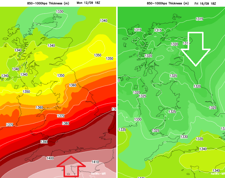
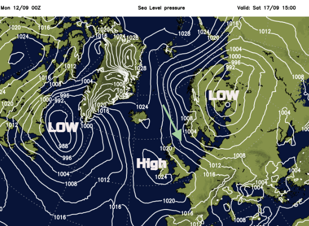
As we head towards the middle of September, the remnants of ex-hurricane Danielle are already impacting western Europe. There is heavy rain in places but also very warm air being pulled up through France into England on Monday. The main low remains west of Portugal but frontal bands will move over the UK and link to another low centre from near Iceland. This low deepens as it moves towards Scandinavia and becomes the dominant feature for northern Europe for the rest of the week. Gradually high pressure builds in for the UK from the Atlantic but will pull cooler air down from the north first. This could bring a touch of frost on the grass in the north as the daylight hours reduce.
Rain will affect southern Britain on Tuesday and early Wednesday with the risk of heavy downpours and maybe thundery ones. This fades as the high moves in. However, around this high and with the low pressure over Scandinavia, the northerly flow will bring more cloud and could give showery rain to exposed coasts.
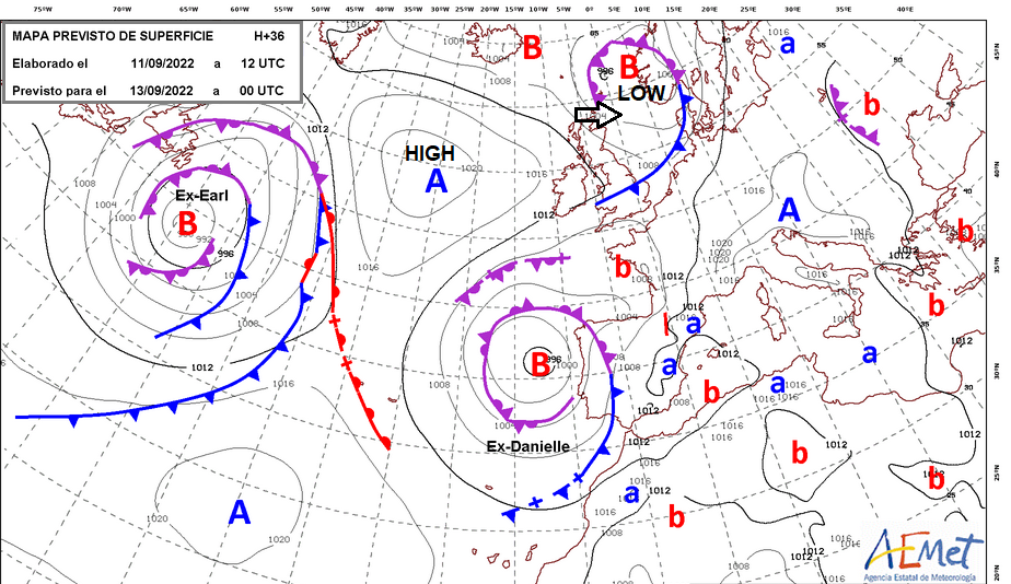
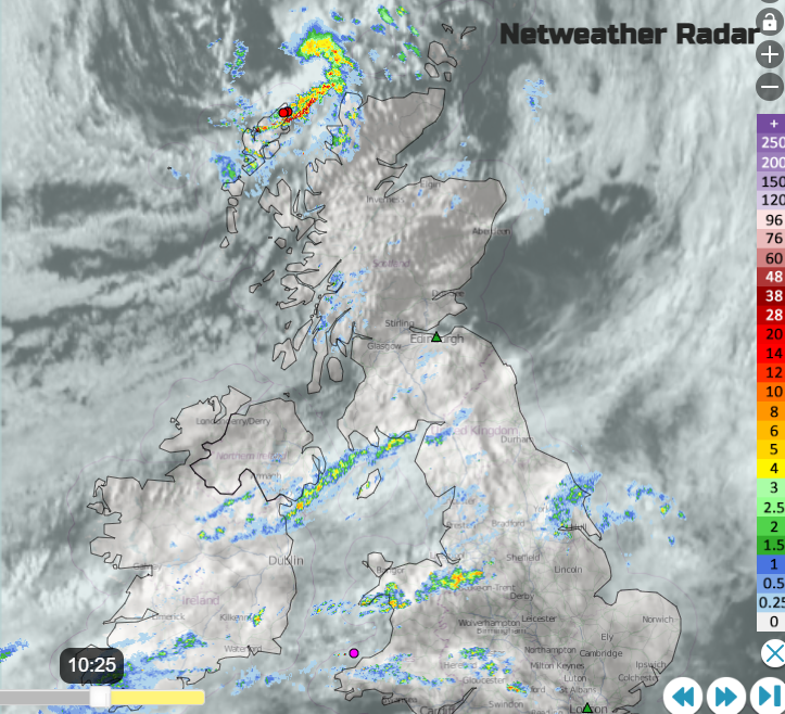
A week ago, there was the possibility that ex-Danielle could have come closer to the UK which would have brought very heavy rain. It is Portugal with the rain, wind and thunderstorm warnings today, parts of Spain on Tuesday. The extending frontal bands have brought more cloud and outbreaks of rain across Cheshire to North Yorkshire, heavy rain for western Gwynedd and showery clusters for County Down and Manchester.
Edinburgh will see fine weather for Monday and Tuesday. It is to the north of the frontal bands. It will be bright and dry along the Royal Mile. Today will feel fine at 17C but it will feel warmer tomorrow with hardly any breeze and more sunshine.
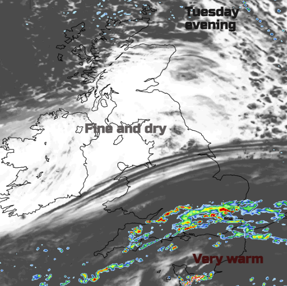
The wrap-round occlusion (see brightly coloured thundery swirl on the radar above over Lewis) will throw more heavy showers over the far northwest of Scotland this morning. These push down to Aberdeenshire by Monday afternoon. The fine, sunny weather extends through more of southern Scotland, and over Northern Ireland. This band of patchy rain will linger over northern England, and north Wales into Lincolnshire with heavier bursts possible. To the south, there will be warmth, even heat where the sunshine appears. This is the air that is being forced northwards by ex-Danielle. There are heatwave warnings in SW France today with Saharan dust being drawn up over western mainland Europe. Temperatures will move through the twenties Celsius for southern England with 27 or 28C possible. Monday will be the warmest day of the week here.
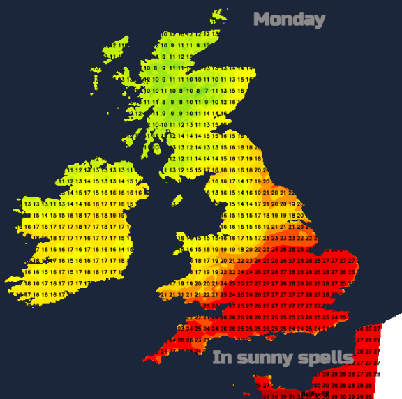
Potential high temperatures if strong sunshine appears today
Many places will see a fine Tuesday but showery rain will set in over southern England during the day. Some places will miss it but others see some sharp downpours. Keep an eye on the radar to see how the lines and clusters are setting up tomorrow. There is uncertainty in the northwards extent and also if thunderstorms will appear. Some could be elevated storms during Tuesday evening and the risk of heavy rain and thunderstorms continues into Wednesday morning. This will be something to watch with the heat over France and ex-Danielle still churning west of Iberia.
During Wednesday the heavy rain gradually clears away south-eastwards and the low over Scandinavia steers the cooler northerly flow our way. The ECM model keeps a lot of cloud and patchy rain over the far north of Scotland and for North Sea coasts on Thursday. This reaches Norfolk by Friday. Northern Britain inland will turn colder through the week but much of the UK falls well down into single figures for Friday night, early Saturday.
This flow means that London will be dry and fair. Not as warm as today but fine with bright skies and light winds. It will feel much cooler by night and for the early morning so for people queuing or arriving early at Westminster Palace it could be a bit nippy. Certainly, a change from recent conditions.
A band of cloud and rain might push further inland for eastern then SE England on Sunday but the high should stay in place through Monday. That would mean fair weather for many on the Bank Holiday and for the State funeral.