Potentially record-breaking, extreme and dangerous temperatures will be with us on Monday and Tuesday. The heat will ease into midweek, though.
Temperatures have been rising this weekend, and even today (Sunday) some places have exceeded 30c - a level most in the UK would consider hot. Tomorrow and Tuesday, there is a possibility that 40c will be hit, which in turn would be a significant jump on the current UK temperature record of 38.7c.
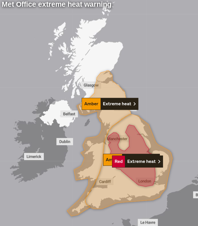
Despite what some naysayers may suggest on social media, this level of heat during the day, alongside widespread tropical overnight temperatures (20c+), is dangerous to health even for otherwise healthy people and may also cause disruption. It's why the Met Office has issued an extreme heat warning, which will switch from amber to red for parts of England tomorrow. They also extended the warning further north into central Scotland earlier today, and it now covers virtually all of the most populated parts of the UK.
So please take precautions, keep hydrated, stay out of the sun, especially during the peak of the day, avoid physical exertion and keep an eye on elderly and vulnerable people, as they may well struggle during the intense but thankfully fairly shortlived burst of heat.
In terms of the records that could fall, these are the all-time (since records began) records for the UK:
| Country | Highest max temperature | Highest min temperature |
|---|---|---|
| England | 38.7c | 23.9c |
| Wales | 35.2c | 22.2c |
| Scotland | 32.9c | 20.9c |
| Northern Ireland | 31.3c | 20.6c |
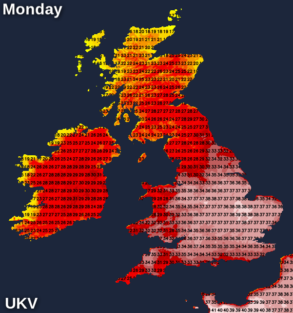
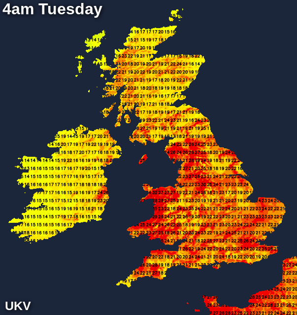
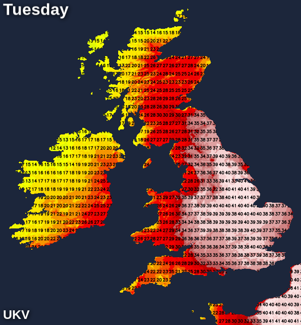
Just about all those records could be in danger. On Monday, maximum temperatures are likely to reach up into the range of 38-41c. Overnight Monday, it's going to be a really close, muggy and uncomfortable one with temperatures widely staying in the low-mid twenties, with the higher range of those values in towns and cities, as well as to the east of higher ground. To put some context around that, the average maximum daytime temperature at this time of year ranges from 22c in southern England to 16c in northern Scotland.
Tuesday will be another extremely hot day - the red extreme heat warning stretches throughout the day. Temperatures will be at very similar levels to Monday and may even exceed them in eastern England, with maxes again peaking in the high thirties, perhaps low forties. Some slightly cooler air with more cloud will arrive into western parts later in the day, with potentially one or two thundery downpours breaking out as well.
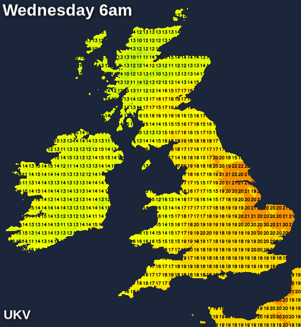
That cooler air in the west will head east fairly speedily during Tuesday evening and overnight. So while it's not going to be a cool night anywhere, with some eastern regions, in particular, staying above or close to 20c, it should provide some more respite to the heat than Monday night will have done.
Along with the cooler temperatures on Tuesday night, there's also likely to be some thundery downpours around - some potentially affecting eastern and southeastern England but most of the rain will run through western England, Wales and up into southern, central and perhaps northern Scotland. Some of those downpours and storms will transfer east during Wednesday with some lively storms and torrential showers possible. There is a fair amount of uncertainty over the details of this, though.
Temperatures during the day on Wednesday will be well down on Monday and Tuesday's extreme values, reaching into the mid-twenties for much of southern and eastern England, the high-twenties, perhaps low-thirties still in East Anglia and the far southeast, and the high-teens or low-twenties elsewhere.They'll also fall quite dramatically during any storms or downpours.
Into Thursday, there'll be a scattering of showers in places, but also some long sunny spells. It'll be warm again with highs into the mid-twenties in the southeast, high-teens to low-twenties for much of the rest of the country. Friday should be mostly dry although we'll have to keep an eye to the south, as it's possible some thundery rain may move north into England and Wales as low pressure potentially moves close by.