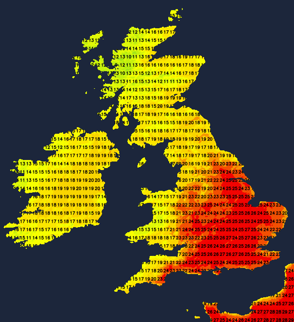
Lots of warm sunshine away from the far north and northwest during the coming days, with temperatures rising steadily towards the end of the week.
Pressure remains relatively high across England and Wales until Friday, keeping it mostly dry. This'll be good news for the final day of the nicely poised Test Match between England and New Zealand at my beloved Trent Bridge. It will also become increasingly warm over the next few days, culminating in a hot end to the week, particularly across central, southern and eastern parts.
Atlantic systems give rain at times for much of the day over the North and West of Scotland, where it'll be misty with patchy fog, especially over coasts and hills exposed to a South Westerly wind. Other parts of Scotland, Northern Ireland and the North of England will also see the odd passing light shower, but it'll be dry in generally light winds for most.
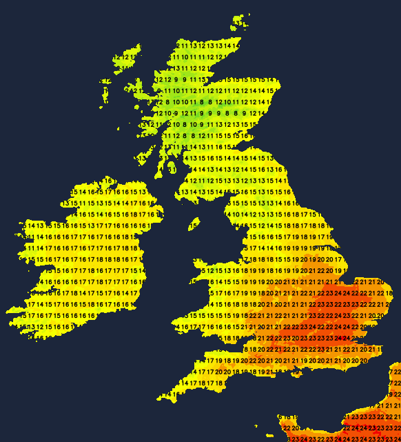
It's been sunny but chilly in places to start, over much of Wales, the South and parts of the Midlands, but cloud amounts through the day will vary. Nevertheless, most will have at least some warm sunny spells that'll tend to lengthen towards evening as skies begin to clear. Top temperatures only 12 to 14C in the far North West but 18 to 22C more generally, with 23 or 24C likely where you see the best of the sunshine in the South and South East.
The Western Isles, Highland and the North of Scotland see further rain or drizzle at times into the evening, where it'll remain misty in a South Westerly breeze with patchy hill and coastal fog. Any showers elsewhere soon fade with some sunshine to end the day for most. A dry night follows with clear spells, but there'll still be a few patches of cloud drifting about. With light winds, it may turn a little chilly and misty again in a few rural areas where skies stay clear, but temperatures are not expected to fall below 8 to 13C.
Wednesday begins with a mix of patchy cloud and sunshine, but for most, it'll end up another fine day with sunny spells in light winds. In comparison, the North and West of Scotland continue to see further mist, rain or drizzle at times in a South to South Westerly breeze. There may also be some rain or drizzle towards Donegal, but much of Northern Ireland should end up fine and warm. Temperatures begin to climb, reaching 18 to 24C generally but as high as 25 to 27C across parts of the South and South East. Across the far North West, however, 13 or 14C is the best you can expect.
The far North and West of Scotland, together with Tyrone and Fermanagh, may see showers after dark as a meandering Atlantic front approaches from the North West. Elsewhere it'll be fine and dry in light winds, with a mix of patchy cloud and clear spells. It'll turn misty here and there again, with a few fog patches forming later in rural areas on a mild night when temperatures shouldn't fall below 10 to 15C.
The heat then continues to build, making it hot and humid by Friday, especially over England and Wales. Meanwhile, Atlantic fronts will be working their way from the North West into Scotland and Northern Ireland, bringing cooler, fresher conditions.