Low pressure overhead today means sunshine & thundery showers for most. Fewer showers, more sunshine on Thursday, before winds pick up on Friday, as ex-Tropical Storm Alex arrives to the northwest, with gales across the coastal west.
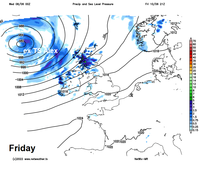
There is potential for some unseasonably strong winds across northern and western areas on Thursday and Friday, as a deep low, previously Tropical Storm Alex, moves in to the northwest of Britain by the end of the week – bringing strong winds and large waves, with coastal gales.
Yesterday had a warmer feel and for many it stayed dry with sunny spells, though there was more in the way of cloud with some showers for southern England and south Wales. However, the weather has become more unsettled for all overnight, with a band of rain moving in from the southwest. This rain clearing eastern areas this morning, but slow to clear the far north. Following will be sunny spells and scattered heavy, perhaps thundery showers for many. Thursday will see a brief ridge of high pressure build in, bringing a drier day with just a few showers. But trouble is brewing for later in the day and into Friday, as that deep low approaches the northwest.
For now, it’s been quite a warm night, with temperatures falling no lower than mid-teens in the south. But with the warmth has been a band of outbreaks of rain spreading north and east across many parts. The rain has now cleared most of eastern England, but will linger through the morning across Northumberland, southern and central Scotland.
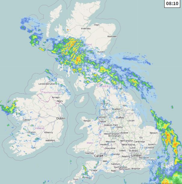
Sunshine and showers will follow through the morning and afternoon across much of England, Wales and southern Scotland – some of which will be heavy with hail and thunder towards eastern England. A Thunderstorm Watch has been issued. Cloud and rain slowly clearing north across northern Scotland, cloud and patchy rain also returning across N. Ireland. Showers becoming fewer across Wales and SW England, but it will turn rather breezy here. Temperatures reaching 18-21C across England and Wales, 14-17C across Scotland and N. Ireland.

Showers should generally ease then fade this evening and overnight, to leave mostly dry conditions with clear spells, though a weakening front could bring thicker cloud and the odd shower across N. Ireland, SW Scotland and northern England.
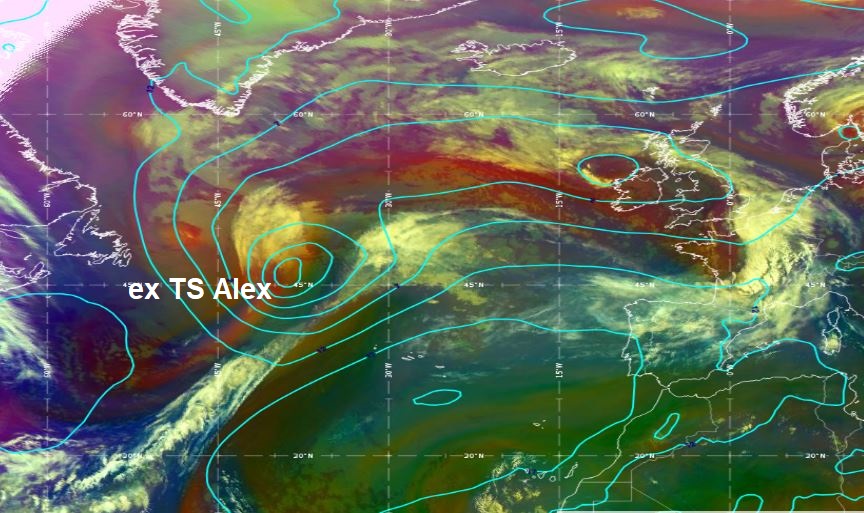
Then we look out into the north Atlantic at a swirl of cloud, on the satellite image below, the remnants of ex-tropical storm Alex, which brought heavy rain and substantial flooding across parts of Florida and the Bahamas.
As it approaches the west of the British Isles on Thursday, it won’t bring much in the way of rain, just some thicker cloud and some patchy rain across SW England, Wales and Ireland through the day. Also some light showers ahead of this across northern areas. Otherwise, many central and eastern areas of England will stay dry with sunny spells on Thursday, as a brief ridge of high pressure builds ahead of the Atlantic low. But as the deep low arrives to the west of Ireland by late evening, it will whip up strengthening winds in the west. Temperatures reaching 16-18C across Scotland and N. Ireland, 17-21C across England and Wales.
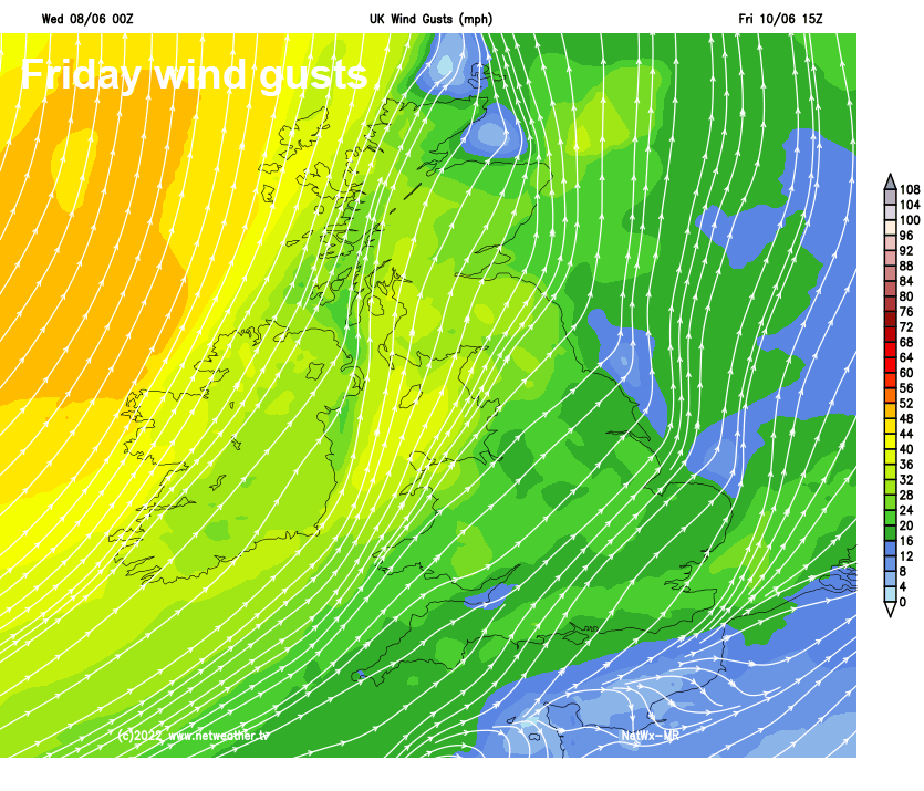
Becoming rather windy in the north and west Thursday night and through Friday – as that deep low spins closer out over the Atlantic to the northwest of Britain. Gales developing around coastal areas in the west and northwest, with gusts reaching 40-50mph, gusts of 30-40mph possible inland across the north and far west. Blustery showers will blow in through the day on Friday across western Scotland, N. Ireland, Ireland and Cumbria. But elsewhere, after a cloudy start in the south, with some patchy light rain or drizzle, it’s looking like it will become increasingly sunny and drier by afternoon, just the odd shower across Wales and SW England, best of the sunshine in the east. It is looking likely the warmest day of the week too, as that ex-tropical low pulls in sub-tropical air from way to the southwest. Temperatures reaching 19-23C across England and Wales, 18-20C across Scotland and N. Ireland.
Staying windy across the north over the weekend, particularly on Saturday, as that deep low continues to track eastwards to the north of Scotland. Showery across northern areas too both Saturday and Sunday, heavy and frequent across western Scotland on Saturday, perhaps lighter on Sunday. Much of England and Wales, away from the northwest – which will see some showers, will be dry and bright or sunny but breezy over the weekend