A cool, unsettled start to the week. Pleasantly warm in any sunny spells but feeling cool under the cloudy skies even with light winds. Uncertainty still for the Jubilee weekend forecast.
The week starts with a flimsy low pressure over the UK bringing showers and cool air. Later in the week, with eyes on the Jubilee weekend, there is no definite pattern showing itself yet. So, plenty of uncertainty in the forecast for now, but a tilt towards a bit warmer than staying with this cool air.
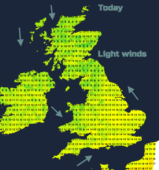
The air is cool, caught around the low pressure as it moves over from Scandinavia and flowing down from the north. At this time of year, any sunny spells can still make it feel warm. In the end of May strong sunshine, the temperatures could reach a pleasant feeling 15 to 18C, maybe higher for London by tomorrow. However, under the cloudy skies or as a shower passes you will notice the 11 to 13C air temperatures and wonder where is summer? The winds will be light so that is a bonus.
Last night there was an air frost in East Anglia, Santon Downham down to -1.2°C and Cavendish -0.3°C

“most likely area for thunderstorms to develop, this activity perhaps organising along this zone and, as it will be slow-moving, may bring a risk of localised flooding.” Convective Forecast Mon 30th
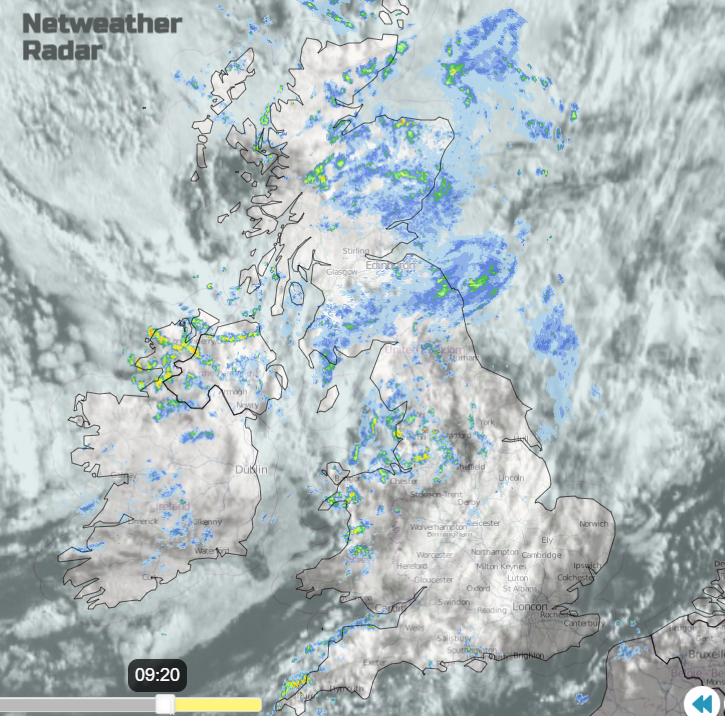
There will be a peppering of showers across the UK today and tomorrow. With hardly any breeze these will be slow-moving and also heavy. There is a low risk of thunder and sudden localised surface water issues for prone spots if they catch a hefty downpour. Some areas will miss the showers today and so have a fair Monday. Others could see many showers and feel cool, so feel the weather is rather unseasonal.
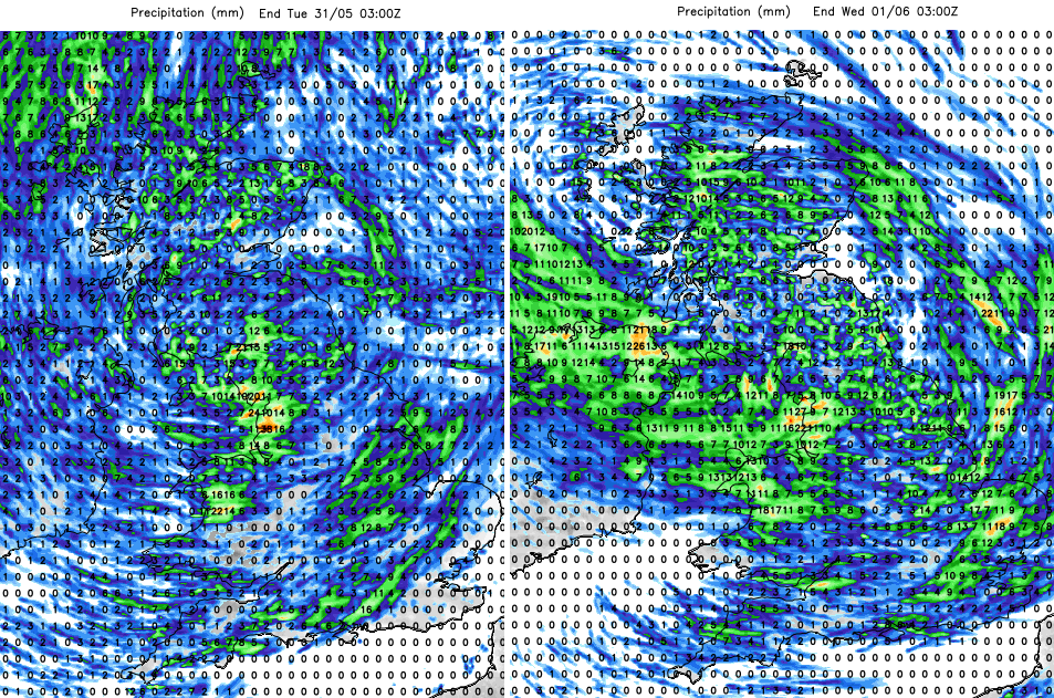
Rainfall totals for 24 hours each showing showers rotating around the low centre, hit and miss nature
These showers rotate around the low pressure over the next few days. North Wales and NW England are already seeing heavy downpours to start Monday. Heavier clusters appear over Britain today as Northern Ireland becomes clearer tonight. Bands of heavy showers will move east from the Irish Sea tonight and another trough into western Scotland. Tuesday sees a rash of showers across the UK with heavy slow-moving downpours and the risk of lighting and thunder. Things improve for SW Britain during Tuesday afternoon. More sunshine and drier as pressure begins to rise and the cool air aloft looses its grip. There are signs of a wet spell for Northern Ireland late afternoon and evening which heads to Wales and NW England during Tuesday night.
It will be cool by night with temperatures down into single figures and the risk of a grass frost for Monday night for central southern England.
Tuesday will have lots of sharp showers, Wednesday will have fewer and more chance of bright, even sunny weather. So still the risk of showers with heavy midweek downpours for eastern Britain at lunchtime.
The forecast for the long weekend is still proving troublesome. The UK Met Office model has fair weather on Thursday until a small low brings showery rain to Northern Ireland by lunchtime. This keeps the threat of some heavier showers across a central swathe of the UK into Friday. Fine to the north and south of these downpours though. Into Saturday there could be some heavy showers, even thunderstorms threatening the far SE but still uncertain. Will it Thunder?
The GFS has showers for northern half of UK on Thursday, a wider central swathe on Friday, particularly wet for NW England and then the focus of showers over southern Britain into Saturday. It shouldn’t be as cool by then.