A mixed end to the working week is on the way but away from any persistent rain or showers, it'll be warm in the sunshine.
Whilst we had a few heavy, locally thundery showers yesterday, the farmers and gardeners still need further rain. Tomorrow will bring some for most as a cold front works its way steadily south and eastwards across the country. A large anticyclone then becomes established across Britain, bringing increasingly fine weather for many over the weekend and eventually very warm conditions, briefly into next week.
Sunshine has been in short supply so far this month, so this morning's fine start over much of the East and South has to be welcomed. However, a few places have begun dull and misty with patchy fog, but this'll soon clear. Elsewhere there's more cloud, but this'll break over Wales, the remainder of England and across East Scotland, where early showers will quickly move away. So sunny intervals for most today, and apart from the odd light shower as cloud builds somewhat later, it'll be dry. Light West or South Westerly winds will give a warm afternoon, with top temperatures 17 to 20C, but perhaps as high as 21 or 22C across South and South-East parts.
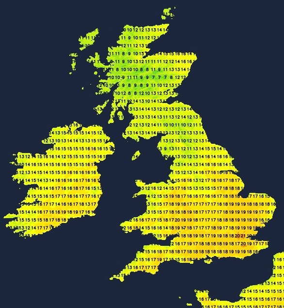
Down and Armagh could also see a few sunny intervals, but it'll be mostly cloudy for the remainder of Scotland and Northern Ireland closer to Atlantic fronts. There'll also be some rain in the North and West that may become more persistent and heavier later. A more noticeable South Westerly wind here will be strongest over exposed parts of Highland and across the Northern Isles, with top temperatures between 10 and 15C.
It continues mostly dry into the evening and after dark across much of England and Wales, with skies breaking at times to give clear intervals in the East and South. Across Scotland, Northern Ireland and perhaps Cumbria later, it'll be turning wet with some heavy rain in places, but with clearer skies, although still with a few showers moving into much of Northern Ireland and the far North West towards dawn. But on a mild night everywhere, temperatures are unlikely to fall below 8 to 11C.
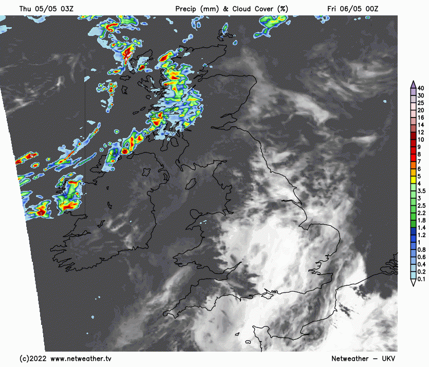
East Anglia and South see further sunny spells tomorrow, leading to another warm afternoon as temperatures reach 20 to 22C again, but cloud will tend to increase. There'll be some rain across the remainder of England and the North and West of Wales as a cold front works its way from the North West. Brighter weather, with scattered showers already across Northern Ireland and the North and West of Scotland, should eventually follow. As the name suggests, a cold front will bring lower temperatures, with 10 to 15C expected here in a mostly moderate South West or Westerly wind.
It'll be the turn of South Wales and many central and southern parts to see some rain into the evening or after dark, with a wave along the cold front perhaps giving some heavier bursts of rain here for a time. But overnight, there should be a clearance working down from the North. Elsewhere you'll see broken skies and just scattered showers, these mostly in the North and West. It'll be a somewhat colder night though in a North Westerly breeze, with minimum temperatures 2 to 5C in the North low enough for a touch of ground frost briefly around dawn in some sheltered valleys and glens and 6 to 8C further South.