A much milder start to this week with temperatures into double figures. The Atlantic air will bring plenty of rain to some parts of the UK, turning to snow for northern Scotland as colder air returns midweek.
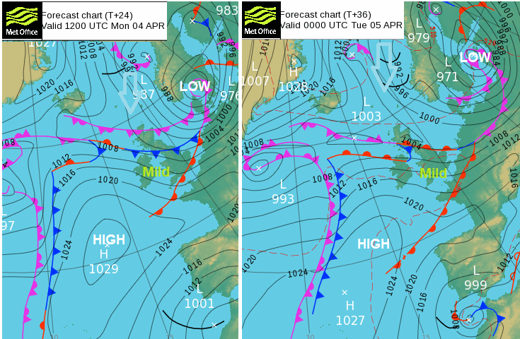
There is milder air to start the working week with temperatures moving into double figures. It’s quite a change, with rain and blustery winds, even strong gusts for Monday morning. Last week’s cold Arctic air has been replaced by mild, blustery and damp Atlantic air flowing over the top of a high pressure to the southwest. However, the cold air is still lurking just to the north. It will take hold again gradually from midweek.
The mild air in the warm sector over much of the UK today, but cold air not too far away
The low centre is moving over southern Scandinavia. The warm front rain continues southwards over England this morning with much of the UK then in the warm sector. However, the cold front pulls down through Scotland by lunchtime with a following occlusion and temperatures dip in the far north. That cold front stalls and starts to wave which results in two things. The cold air doesn’t reach any further and some areas will see heavy and persistent rain. NW England, parts of Northern Ireland and particularly Scotland. The mild air to the south but that cold Arctic air to the north. So, there will be snow, over the Scottish mountains, but also by mid-week to lower levels in the far north, with ice.

Much milder for Monday although with blustery winds
Today in the milder air temperatures will rise 10 to 14C with maybe a few sunnier spots into the mid teens. Southeast Britain started the day ahead of the warm front, so a slower rise for Kent and Sussex. The brisk west to northwest wind will be noticeable but find some shelter and even sunny spells in the east and the difference from last week will stand out. Northern Scotland back into single figures with that incoming colder air and north breeze.
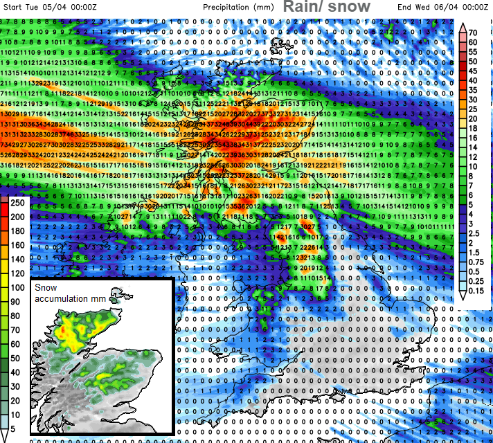
Heavy and persistent rain Tuesday (and on Wednesday) although dry for southern Britain and eastern England
The front waves about with a fair amount of cloud and patchy rain later and overnight. Another mild night away from NE Scotland where there will be a frost inland. Early on Tuesday, the rain in the northwest becomes heavier, over the north of Northern Ireland for a time, North Wales briefly and then setting in for NW England and Scotland. It shifts about slightly, but western Scotland looks very wet on Tuesday. As the day progresses and that rain band continues to interact with the cold Arctic air over northern Scotland, there will be snow.
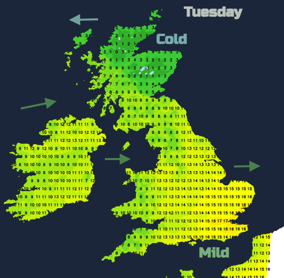
Quite a divide with cold Arctic air in the far NE but many still in the milder Atlantic air on Tuesday.
Low pressure slides in from the west and keeps the frontal band across northern Scotland for the rest of the day, so more heavy rain and more snow, particularly across the Highlands and Grampian. A cold front slides across Northern Ireland and Southern Scotland, then NW England and north Wales by the evening with snow over the hill tops. The rain and snow continue over central and northern mainland Scotland into Wednesday morning. Further south, there will be brighter skies, some sharp showers on a brisk westerly wind and a marked change midweek through the UK to colder air as the wind veers to the north and the frost returns.