This coming weekend won't be like the last. April starts off cold with the Arctic air still over the UK. In the breeze it will feel chilly, less so in the sunshine and still frosty by night.
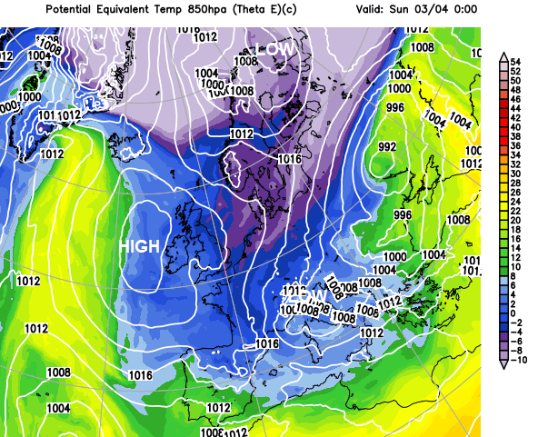
The cold air will still be around this weekend. For the end of March into early April there has been a shift to a chilly Arctic flow with icy rain and also snow showers and frost. That cold air continues to plunge right down through western Europe, the western Mediterranean and even reaching northern Africa at the end of the week. High pressure will be building to the west of Ireland, settling our weather down but also keeping that cold north breeze. Things only begin to change on Sunday night into Monday when milder Atlantic air manages to tumble over the top of the high.
At this time of year, there is warmth in the sunshine for sheltered spots, but this air is cold. So, in the breeze, the shade, and certainly after dark, it will feel decidedly chilly.
Saturday starts off with another frost, particularly for England and inland Wales. The coldest air will still be over SE Britain along with a brisk northerly wind. Anyone playing or watching Saturday morning outdoor sports, do wrap up warm. With the cold, damp air and the wind chill, it will be a shocker compared to last weekend.
Further north there have been signs of feature getting caught in the northerly flow. The timings are likely to vary but an area of cloud and precipitation looks to move down through Scotland and Northern Ireland. For a time, this could bring some snow. Mainly for the hills and mountains of northern Britain but we’ll have to see how it develops, where it moves across and at what time of day. It looks to back the winds for a time resulting in a less cold westerly in the morning. Then there will be showery outbreaks progressing southwards through Britain during Saturday. Some areas will stay dry, southern England looks likely. More cloud and showery rain could move in off the North Sea as well.
In brighter spells, Belfast, Glasgow and Manchester should reach 10C, although worth staying out of the breeze. London could struggle, staying in single figures.
The winds ease down during Saturday night and the temperatures fall away. It will be cold and feel damp with another frost but not as widespread. Some areas will keep more cloud, beginning to feed in off the North Sea in the north to NE flow. This will feel cold if you are out in it. The coldest air will still be over East Anglia and Kent to start Sunday so even with sunny spells there will still be a chill in the air.
Mostly it looks fair and bright for England and Wales on Sunday with temperatures more widely back into double figures so 10 to 13C. As the milder air begins to arrive in the far north of Scotland, over the top of the high there will be more cloud and the westerly wind will pick up. So that will be a change with rain arriving at some point. Currently, it won’t turn wet and windy from the north until after dark.
The main thing about this weekend is that it will not feel warm, it is not going to be like it was in March. And even if it looks lovely out of the window, don’t be fooled. The air is still cold.