With high pressure dominating, the fine, dry and often sunny early spring weather is set to continue this week.
With high pressure dominating, the fine, early spring weather is set to continue this week. There'll be lots of sunshine, but with winds off the North Sea, eastern coastal areas will be cooler and perhaps more cloudy at times. It stays predominantly dry, entirely so for some, but with a few showers towards the East coast at first and also a few isolated ones on Tuesday and Wednesday. These could be sharp, but you would be unlucky if you caught one.
Lots of sunshine and blue skies again today once patches of mist and low cloud have cleared mostly from Pennine regions, but it'll be somewhat cooler than yesterday. Parts of East Anglia and the South East, mainly towards the coast, could catch a shower later, as could the far South West, but it'll continue dry for the bulk of the country.
Along some North Sea coasts, an East or North-East wind prevents temperatures from getting higher than a chilly 8 or 9C, but inland and in the West, 12 or 13C is more likely. Sheltered parts of Highland and Moray could reach 16 or 17C, but this'll be down on the 20C hit yesterday. Although blustery at first along some English Channel shorelines, winds decrease a little through the day.
Coasts of East Anglia and North East England may see the odd shower, as again could the South West, but it remains fine and dry with clear spells for the bulk of the country. A few patches of very low cloud may also 'roll-in' off the North Sea later to affect some coastal areas, with the South West and South Wales turning misty fairly generally. There'll be a touch of frost by morning, chiefly in sheltered rural regions, with temperatures down to -2 in the coldest spots but more typically 2 to 5C.
Monday sees lots of fine, sunny weather again once patchy mist and low cloud has cleared, but cloud amounts over England and Wales may vary. Wales and the South West may also catch an isolated sharp shower as could coasts of the North East and East Scotland, but for most, it stays dry. After a chilly start, where you see the best of the sunshine, temperatures reach 13 to 15C, locally 16 to 18C across parts of the North and West and maybe southern England. It'll be cooler, though, where you keep cloud and murk is slow to clear in a light or moderate South-East wind. Any showers fade after dark, but mist and patchy fog may become more widespread. A touch of frost is likely again mainly in the North, with the lowest temperatures mostly between 2 and 6C.
Mist, patchy fog, and low cloud may take a while to clear from eastern areas, but for most, it'll be another fine day with sunny periods. This may be hazier than of late over England and Wales, but it stays largely dry apart from the risk of catching a very isolated sharp shower.
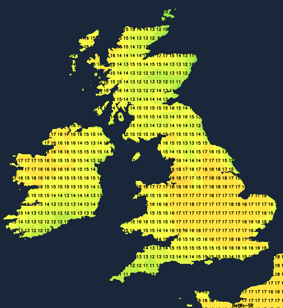
Temperatures will be on the rise in an East or South Easterly breeze, reaching 14 to 17C generally and 18 or 19C in sunnier, more sheltered spots. Mist, patchy fog and some low cloud return overnight, but with less risk of frost.
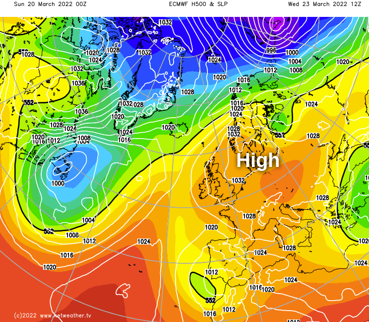
With high pressure still firmly anchored to the East of the British Isles, the fine early spring weather continues.
With the wind off the sea, the East coast will be cooler, but it'll be another fine day with sunny periods for most. Apart from the continued risk of an isolated sharp shower, most parts remain dry, with temperatures climbing. A warm 20 or 21C is possible in London and across more sheltered western areas, with mist, patchy fog and low cloud returning overnight.
The end of the week brings little change as high pressure continues to bring some lovely early spring weather with more warm sunshine once overnight mist, patchy fog and low cloud has cleared. Temperatures could again get close to 20C in the warmest spots once more, although it'll be cooler in coastal areas, with some mist and murk perhaps slow to clear from a few places before returning overnight.
The weekend may see the beginning of a change, as our resident anticyclone shows signs of slipping to the North West. This would bring somewhat colder but clearer air from the North, but apart from the odd shower over the North and East of Scotland, it would continue mainly dry. Cloud amounts may also be more variable, although there would still be sunny spells. It would be noticeably colder at night, though, bringing the return of frost, but with morning mists and patchy fog less likely.