With pressure rising steadily and yesterday's heavy rain in the East now cleared into the North Sea, we can expect a good deal of fine early spring weather in the coming days.
With pressure rising steadily and yesterday's heavy rain in the East now cleared into the North Sea, we can expect a good deal of fine early spring weather in the coming days. But for St. Patricks Day, we have a slight hiccup, as Atlantic systems bringing windy, showery weather sweep across the North.
So after a bright but frosty start in the East, Scotland sees showers today. We already have some in the West that are heavy, giving local hail, thunder and hill snow in the North, these spreading East through the day. One band of showers has already crossed Northern Ireland, with another moving in from the West this morning, followed by clearer weather and lengthening sunny spells from around mid-afternoon. A chilly southwest wind will be strong in the North with top temperatures only 6 to 8C across much of Scotland, but over Northern Ireland, 10C is more likely in the sunshine later.
England and Wales begin fine but with a slight frost and a few fog patches, chiefly in rural areas. It remains fine with sunny spells in the East and South but with patchy cloud later. Elsewhere cloud will build to give a few showers, mainly over North West England and parts of Wales, with one possible at the Cheltenham Festival before the final race. Despite the cold start, temperatures reach a pleasantly mild 12 to 14C in most parts, in a light or moderate South Westerly wind.
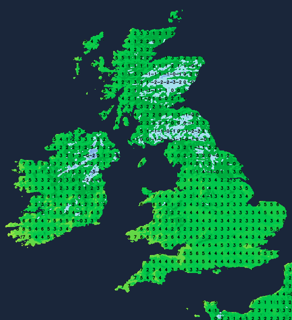
Any showers remaining in the North quickly fade after dark, leaving most parts with clearing skies as pressure rises strongly. This allows winds to become light, especially over England and Wales, where mist and patchy fog will develop, especially across the Midlands and Wales. There'll also be a slight frost where skies stay clear, particularly in rural areas, as temperatures mostly fall to between -3 in the coldest spots and +3C. Apart from a few showers in the far North West, where it'll be milder in a southerly breeze, it'll be dry.
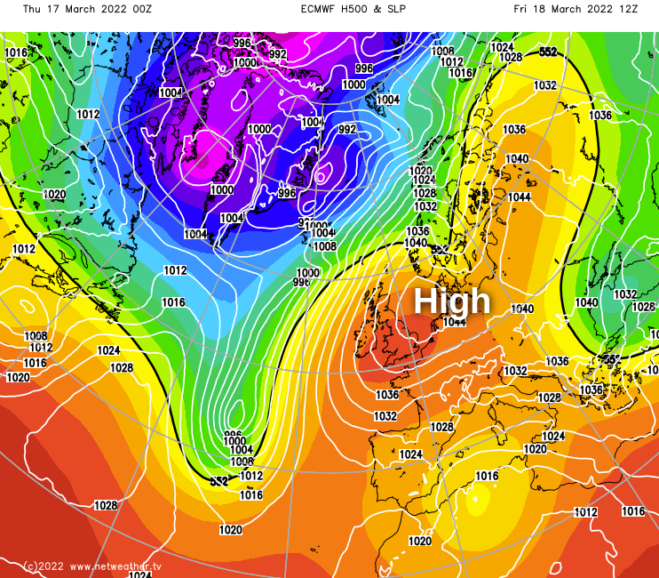
With an intense anticyclone established in the North Sea by tomorrow, Friday will be dry and fine almost everywhere, with lots of early spring sunshine.
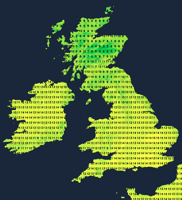
However, areas of mist, patchy fog, and very low cloud may take a while to lift and clear from some western and central parts, but once these have gone, there'll be blue skies. Temperatures will respond accordingly in the sunshine, reaching 12 to 15C fairly generally and locally 16C across parts of the North West and along North facing showers of the Moray Firth.
After dark, patchy cloud and a southerly wind keeps the far North West somewhat milder, while coastal parts of East Anglia and the South East may see a North Easterly breeze bringing patchy low cloud ashore, making it grey here in a few places by dawn. But for most, it'll be another fine, dry evening and night with clear spells. It'll turn cold again, allowing mist, patchy fog and slight frost to reform during the early hours, with temperatures mainly in the range of -3 to +3C again by dawn.
As for the coming weekend and beyond, high pressure dominates, bringing mainly dry, occasionally spring-like weather. But a few perhaps sharp showers may work their way North across the country on Sunday, with misty, hazy conditions and some patches of very low cloud at times into next week, these mainly in the East. It should also become warmer by day, with less risk of frost at night.