A mixed bag at the weekend with fair weather for many on Saturday before an Atlantic low heads in from the southwest. Wet and windy weather into Sunday as this moves north.
This weekend’s weather will be changeable with Atlantic rain, blustery winds and a low pressure that could bring some very wet and windy weather to parts of the UK and Ireland.
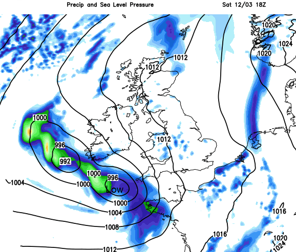
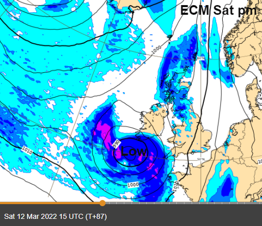
This low which arrives later on Saturday from the southwest will dominate the weather well into Sunday. There will be gales, coastal severe gales, heavy rain and snow for mountains. The air isn’t especially mild, and it will feel cold under the rain with the blustery winds. However, in sunny spells with some shelter from the breeze, it will feel mild. There will be light winds each morning and for most of Saturday, before the low arrives. Temperatures will vary from 7C to 13C although there is the potential for up to 15C which will feel pleasant enough for early March.
The Six Nations resumes this weekend.
Friday 8pm Wales v. France Cardiff The afternoon weather looks wet and blustery on the current forecast as two frontal bands head east across Wales. Hopefully they will have cleared by Friday evening to leave better weather for the game. Drier and not as windy but feeling damp and cool around 8C.
Saturday 2:15pm Italy v. Scotland Rome High pressure over Italy should bring quiet weather. It looks dry, calm but with a fair amount of cloud.
Saturday 4:45pm England v. Ireland Twickenham. The weather looks fair but blustery with a southerly wind. It should be dry into the evening, but the incoming low pressure will need to be kept an eye on.
Friday afternoon and evening looks very windy for Grampian, Caithness and the Northern Isles with strong, gusty SE winds. If you are heading to the hills at the weekend, do be aware of the incoming low pressure from the southwest. Saturday looks fine for many parts but for Exmoor and Dartmoor conditions will deteriorate later on Saturday and by the evening for southern Wales. Heavy rain can lower the air temperature enough that the precipitation turns to snow at this time of year, so icy rain and sleet could appear. Snowfall is forecast for the Scottish mountains during Saturday night.
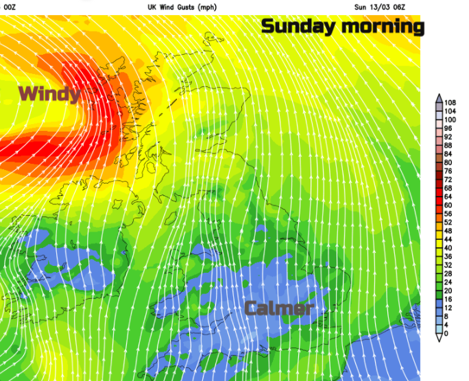
The strong winds will affect western Britain, southern Ireland on Saturday and then Northern Ireland Saturday evening. Western Scotland, particularly the Northern Isles early on Sunday.
If you are looking at a weather app to make plans for this weekend, do bear in mind that the position of this western low will change slightly and so the reach of the rain, the area of strongest winds and gales may change. Even as the low clears away to the north the UK is left with a messy picture for Sunday. A mix of brighter spells then showers, or bands of rain pulled behind.