We are heading into a warm and changeable spell of weather, with mainly southerly winds.a0 Temperatures could hit 17 or 18C in the southeast tomorrow.
We are heading into a warmer and changeable spell of weather, with mainly southerly winds. Temperatures could hit 17 or 18C in the southeast tomorrow.
Today, we'll see a west-east split, with cloudy skies and outbreaks of rain affecting most western parts of the UK and dry, sunny weather in the east. The rain will slowly clear eastwards from Northern Ireland, but it will take until late evening to clear the far east of Northern Ireland. It will also spread eastwards across much of Scotland during the day, but it will not reach the east coast of Scotland until late evening.
Until the rain arrives, the east of Scotland will be mainly cloudy but dry, but central and eastern parts of England will have plenty of sunshine and some patchy cloud. It will tend to cloud over from the west during the afternoon and evening, but the cloudier weather will not reach East Anglia until late evening.
Much of eastern England will be warm as well as sunny, with highs of 13 to 15C, but it will be somewhat colder in western Scotland and Northern Ireland under the persistent rain, where highs of 5 to 7C will be typical.
A generally mild night will follow, with some intermittent light rain mainly in the west, although there will be a frost in the west of Northern Ireland, where temperatures will fall close to freezing.
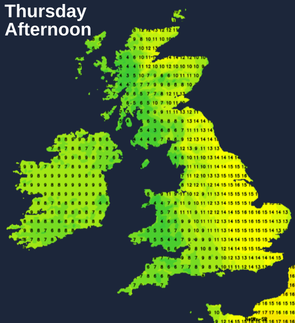
It will be a generally cloudy day for most of the country. There will be some outbreaks of light rain or drizzle at times, mainly for western Scotland during the morning, and then some more rain will spread into Wales and west England during the afternoon. Most eastern parts of the UK, as well as Northern Ireland, will have a dry day. East Anglia and the southeast are expected to have a fair amount of sunshine, which may raise temperatures to 16 to 18C during the early afternoon. It will also become sunny over much of Scotland during the afternoon. It won't be as warm away from East Anglia and the southeast, but highs of between 10 and 13C will be widespread, which is still above average for the time of year.
Rain will move in from the southwest on Friday, which is expected to be heavy and locally accompanied by thunder in Wales and the southwest. Sunshine and showers will follow for most parts of the country on Saturday, but another belt of rain will spread from the southwest late in the day. There will be further rain or showers spreading from the southwest on Sunday. Thus, the outlook remains changeable and warm, but there are hints in the medium-range forecast models that the weather will turn more settled through next week. Winds are also expected to remain southerly, so it looks like staying on the warm side for the foreseeable future.
While the UK's weather will be relatively uneventful for the foreseeable future, in the USA, Iowa is currently reeling after severe tornadoes hit the region over the weekend. Seven people have been confirmed dead, including four members of the same family, and there has been widespread damage to homes and businesses. The most devastating tornado was rated at EF4, the deadliest to affect the region since May 2008. A snowstorm hindered attempts to clear up afterwards during Sunday and Monday.