Much milder and cloudier for Tuesday, with rain for the north. Turning colder for all by Thursday, with wintry shower returning. Remaining unsettled, milder Thursday but turning colder again Sunday.
Temperatures are up and down this week. This morning it’s a much milder start than yesterday and it will remain a mild, cloudy and, in places, damp day. Most of the rain across the north.
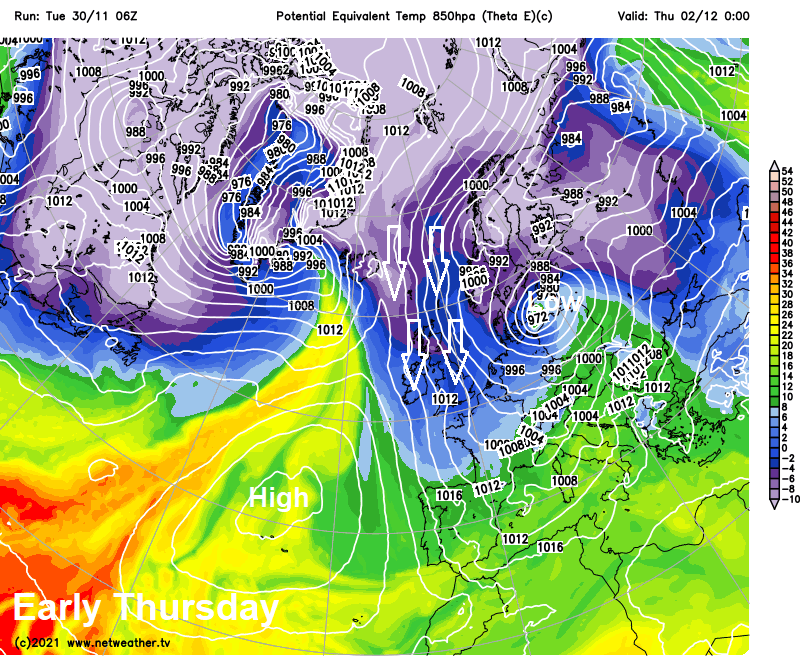
However, just as we get used to the milder air, following rain clearing south across the UK tonight with a cold front the arctic floodgates will open-up again across the north tomorrow, then a cold arctic northerly flow for all on Thursday. The strong northerly wind will bring wintry showers back to northern Scotland and eastern coasts – which may hamper the ongoing repairs following Storm Arwen over the weekend, but the wind won’t be as strong as during that storm.
Temperatures up and down from now until the end of the coming weekend
Then just when you’ve donned the thick winter coat, scarf and woolly hat, it turns milder again on Friday, as less cold Atlantic air from the west floods in behind a frontal system with a band of rain moving east first thing.
Temperatures look to continue to fluctuate through weekend as an area of low pressure moves southeast across the British Isles, it starts off mild but turning colder by Sunday, as winds switch from westerly to northerly or northeasterly.
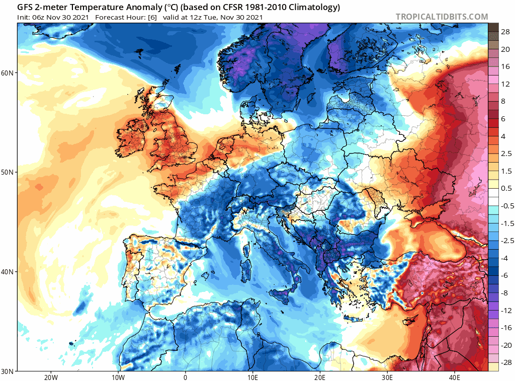
Back to today and what a difference a day makes! Yesterday morning Britain was widely below freezing to start the day, falling as low as -8.7C at Shap in Cumbria. But this morning much milder, 10C at dawn in Shap and elsewhere widely in high single figures, double figures across the far west.
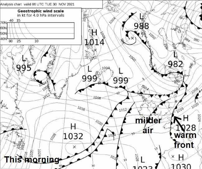
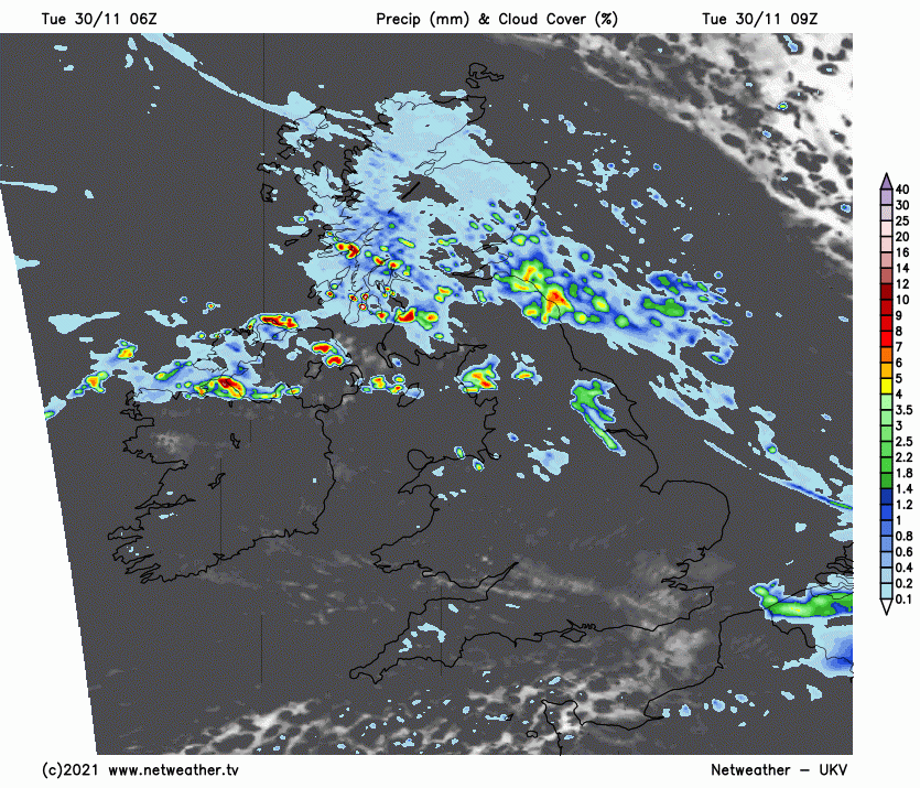
A warm front has moved southeast overnight and has cleared into the near continent to start the day, with a rise in temperatures overnight. So, a milder day for all today, cloudier for many too. There will be some rain many across parts of Scotland this morning, this moving down across parts of northern England. Some patchy light rain or drizzle further south across England and Wales.
Rain becoming more persistent and heavy from the west through the afternoon across western Scotland, N. Ireland and NW England before a band of rain, locally heavy, spreads east and southeast across Scotland, northern England, Wales, Midlands and SW England through the evening. Cloudy with the odd spot of light rain or drizzle ahead of this rain across southern and eastern England. Highs of 10-12C widely today, away from the Northern Isles where it will be much colder.
A narrowing band of rain reaching SE England and East Anglia by midnight, before clearing in the early hours. A blustery northwest wind accompanied by showers in places following across most parts, turning wintry in the north of Scotland as winds turn northerly here.
Then a blustery day Wednesday with sunshine and showers. A line of more organised showers along a front looks to move south across England and Wales, northwesterly winds ahead of the front turning northerly behind the front bringing cold arctic air down across the north in the afternoon – with showers turning to sleet and snow across northern Scotland. Temperatures reaching 8-10C in the south ahead of the front, 6-8C behind the front, 4-6C across northern Scotland as the cold air digs in.
A much colder day for all on Thursday in a cold arctic northerly wind, temperatures struggling to reach 4-5C in the east, 6-8C in the west, but with a ridge of high pressure building in from the west bringing a mostly dry day with sunshine compensating for the cold wind. There will be wintry showers along eastern coasts throughout the day and across the far southwest at first.
Then all change again Thursday night, as a spell of wet weather moves east of the Atlantic all across parts, rain most prolonged and heavy in the south and west this time, a spell of snow preceding the rain for a time across northern areas, perhaps to lower levels for a time but settling mostly over high ground. Rain, sleet and snow clearing east first thing Friday morning, then a mostly cloudy and milder day with a northwesterly breeze and afew showers in places, though some sunshine across the northeast.
The weekend unsettled and windy in places, another spell of wet and windy weather Friday night clearing first thing on Saturday, though perhaps lingering in the northeast in the morning. Otherwise windy with scattered showers, turning colder through the day as winds turn northwesterly then northerly, with showers turning wintry in the north. A chilly but bright day on Sunday, showers around coasts, perhaps wintry where they get inland, but most places dry.