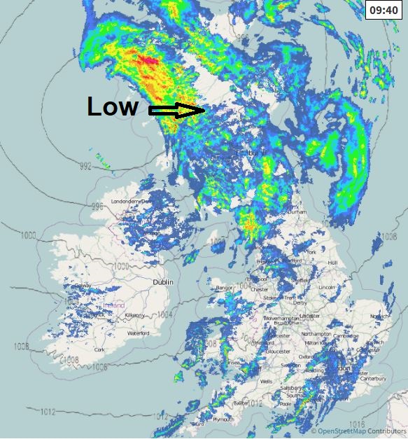
An area of low pressure crossing Scotland will bring a spell of wet weather across the north and some patchy rain elsewhere, windy everywhere with gales in the west. Weekend calmer and drier as high pressure builds in, but still mild.
It’s been mild all week and today will be no exception, but with a deep low crossing Scotland - there will be the addition of windy conditions, with gales across western coasts and hills, and the chance of some rain. However, today’s low will sink into mainland Europe over the weekend, allowing a ridge of high pressure to build in bringing drier and more settled conditions, with some sunshine at times, but also a fair bit of cloud around. The exception will be the far northwest on Sunday - which will see rain move in off the Atlantic.
High pressure in charge this weekend, so for most it will be dry and settled, while remaining mild
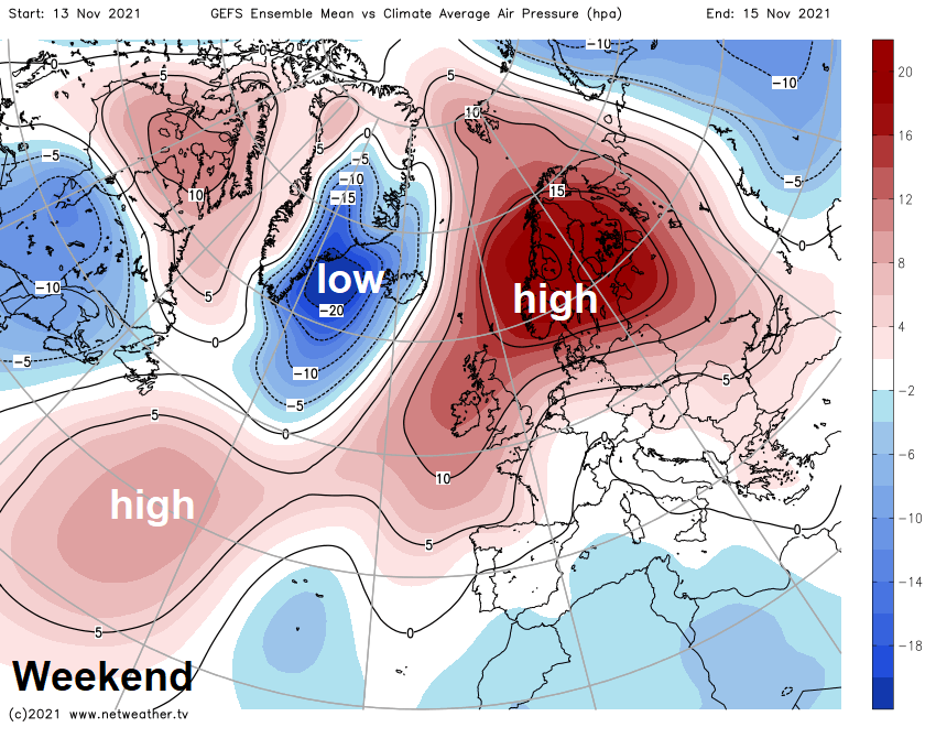
Next week is looking mostly dry, settled but breezy across southern areas with the best chance of sunshine, with high pressure close to the south, perhaps some brief rain mid-week. Northern areas cloudier, windier and prone to spells of rain or showers at times – as Atlantic systems move west to east to the north of Scotland.
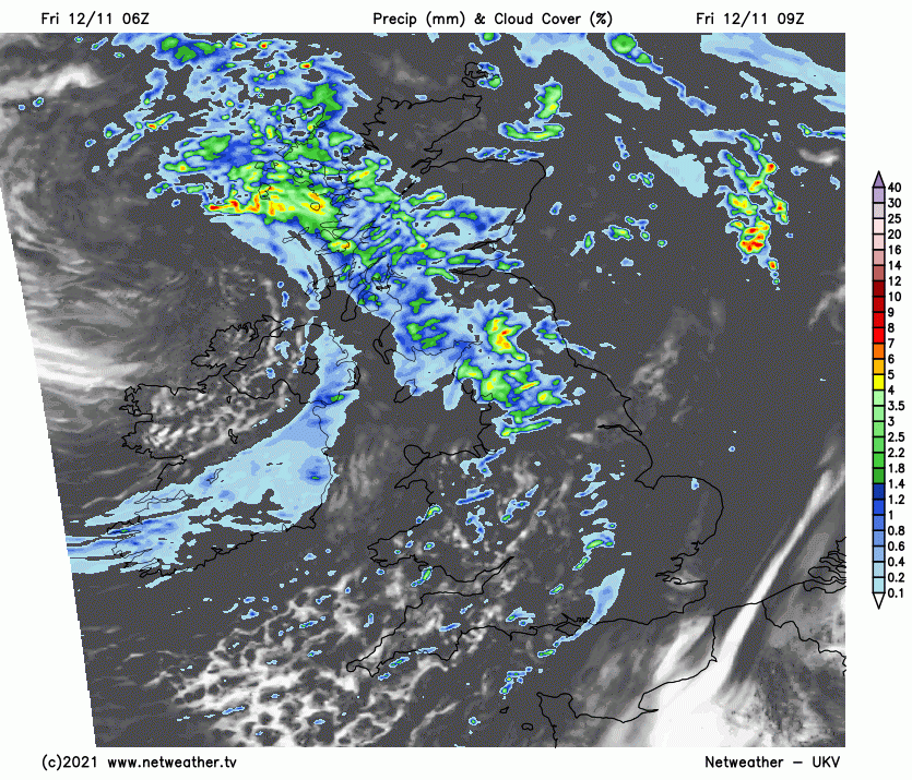
It’s a mild and blustery but cloudy start to the day, with temperatures widely in double figures at dawn, as high as 14C across the far southwest. Outbreaks of rain wrapping around a deep low to the west of Scotland will spread in from the west across Scotland, northern England and north Wales this morning, the rain heavy and persistent across western hills. Rain turning more showery into the afternoon, with some bright spells at times. Elsewhere, windy with some spells of patchy light rain or drizzle spreading east at times, but some drier and brighter interludes too.
Windy everywhere, with gales across western coasts and hills, with gusts of 40-50mph. Rather mild again, temperatures reaching 12-15C.
Winds easing and turning drier with clear spells developing across Scotland, N. Ireland and northern England this evening and overnight, as showery outbreaks of increasingly light rain clear southeast across England and Wales into the North Sea and near continent. Remaining cloudy across with a few spots of rain across southern areas.
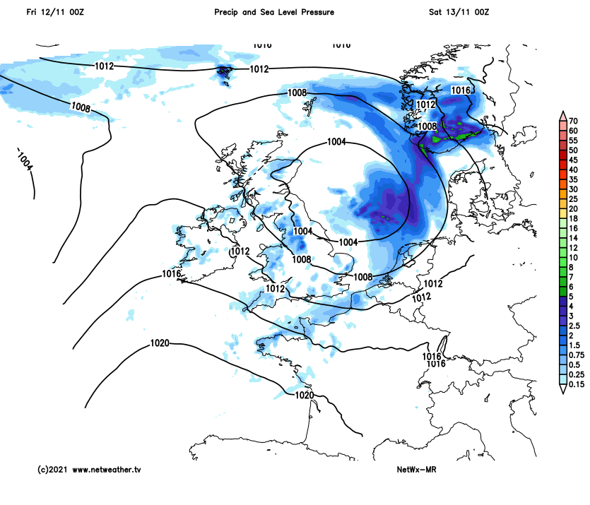
Today’s low moves southeast across Holland and NW Germany on Saturday, with a ridge of high pressure building in from the southwest across the UK to replace it. So we are looking at a mostly dry and settled day with sunny spells, though it will be cloudy and breezy with scattered showers for a time across East Anglia and the far SE of England. Best of the sunshine across NW England and Scotland, thicker cloud and perhaps some patchy light rain or drizzle arriving from the west across N. Ireland and far western Scotland in the afternoon. Mild again, temperatures reaching 11-13C in the north, 13-15C in the south.
Perhaps some fog patches forming Saturday night that may linger in places for Sunday morning, otherwise a mainly dry, mild but mainly cloudy Remembrance Sunday. Some sunny spells possible in the south. Thicker cloud with spells of rain moving in across the far northwest though. Temperatures reaching 12-14C.
Cloudy skies will sink southeast across England and Wales on Monday with a weakening cold front, cloud thick enough to produce some patchy rain across Wales and northern England. Elsewhere dry, best chance of sunshine across eastern Scotland and N. Ireland.
The weak cold front looks to become slow-moving across England and Wales on Tuesday, so mostly cloudy here, with the odd spot of rain or drizzle. Brighter for a time across Scotland and N. Ireland before a more active cold front sweeps rain in off the Atlantic here during the evening while becoming quite windy across the north in the afternoon.
Cold front with some showery rain clearing southeast across England and Wales Wednesday morning, followed by cooler, windy but showery airmass from the northwest, most of the showers in the north and west, perhaps turning wintry over high ground briefly. Generally cloudy and breezy on Thursday and Friday, some spells of rain or showers for northern areas, but southern areas mostly dry and with the best chance of some sunny spells at times. Cooler, temperatures closer to average than they have been this week.