A mixed week but often mild. Temperatures on Wednesday could reach 15 or 16C in the south. Low pressures move by, causing brief changes. Fog to watch out for on Thursday.
A cold front across the UK is creating great contrasts for our Wednesday morning weather. Ahead of it, over much of England and Wales, there is a good deal of cloud and greyness, even dampness. It is mild, very mild in places with temperatures to start this November day 11 or 12 Celsius. The front is giving rain over Yorkshire and north Wales with damp, murky conditions stretching across Britain west to east.
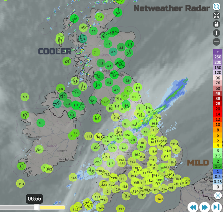
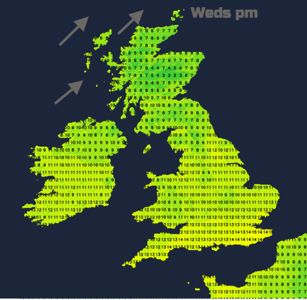
Behind the front to the north, it is brighter and cooler. Sunshine after a nippy start in places with a touch of frost inland. Temperatures are well down into single figures and there will continue to be just a scattering of showers heading down from the northwest in a blustery wind. The southwest wind will strengthen over the Western Isles today with a little wintriness for the Scottish mountains, a few flurries of snow in any showers over the tops of the Cairngorms. But that is about it. For most, there will be light winds, plenty of dry weather away from the frontal boundary which will sink southwards today. Reaching from The Wash to the Bristol Channel by early afternoon. Brightening up for northern England and where breaks appear in the cloud for southern or southeast England temperature could reach 15 or 16C. Only 10 or 11C for Northern Ireland and Scotland.
Tonight, the fading frontal band settles across southern England keeping it mild, cloudy and murky with hardly any breeze. Further north a little low nips by and throws another cold front into NW Scotland and it will be windy, which keeps the frost at bay on the mainland. Shetland will see gales with squally gusts. There could be a gap over southern Scotland, far north of England and also for southern counties of Northern Ireland where the winds will be light enough, still clear spells and temperature could dip for a touch of frost.
There will be a risk of fog by Thursday morning for England and inland Wales. It could be around for Remembrance Day events. For parts of central Britain, it will take its time to clear. A new low pressure will soon be spinning in from the Atlantic. Southerly winds begin to pick up through Ireland. It will still feel mild away from Scotland and the foggy spots. Showery outbreaks of rain appear for western Britain during the afternoon and then heavier bands of rain push over Northern Ireland on Thursday evening, reaching western Scotland
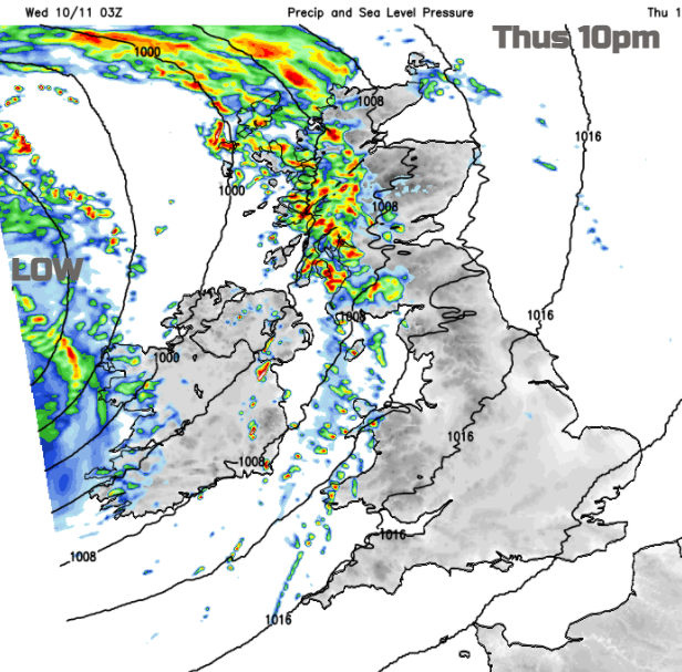
Scotland looks to be under the centre of the low by Friday, so lighter winds here. Cluster so heavy showers swirl around the low with plenty of bright spells too. For most, it will be a blustery day, quite a change for SE Britain. Mild again until the low pulls away into the North Sea and the wind veers to the northwest.
Saturday could be a quieter day as the low centre fades over the Netherlands, more sunshine appears but the flow is from a cool direction. Dry for most although the low to the southeast could still produce a few showers.