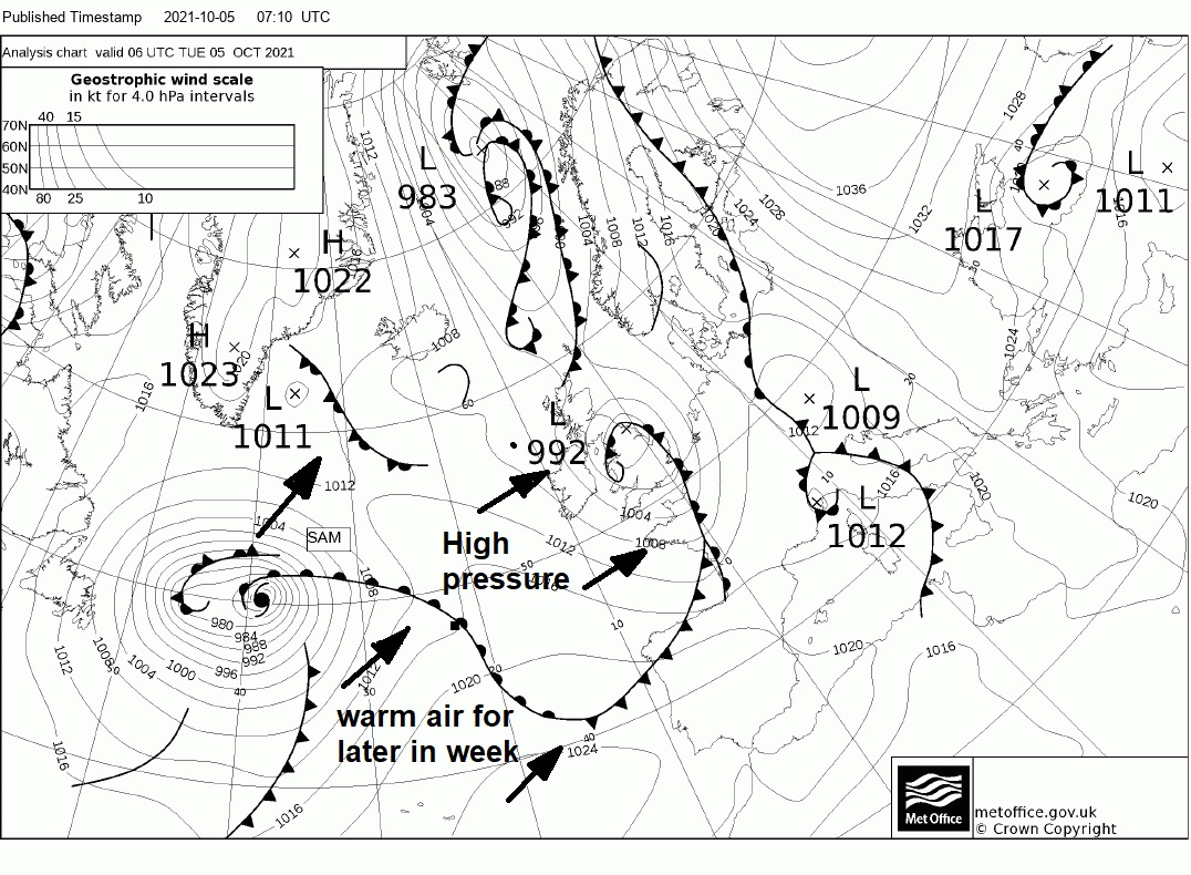
It will turn drier and warmer for many from mid-week, as ex-Hurricane Sam way out west over the Atlantic drags warm tropical air from way to the southwest over the UK later in the week.
A strong jet stream running in off the Atlantic has been close to the south of the UK since late last week, bringing areas of low pressure with spells of rain to many areas, with sunshine and showers in between these systems. The latest of these low pressure systems, which deepened overnight and is moving across northern England this morning, brought a band of torrential rain ahead of it across England and Wales overnight, bringing flash flooding in and around London – which is affecting the morning commute on the roads, tubes and trains for some. This low will linger close to the east coast over the North Sea today, with persistent rain affecting NE England and SE Scotland wrapping around the low.
Flooding in Knightsbridge, London earlier this morning
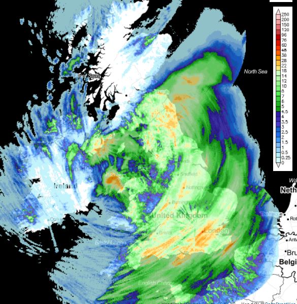
Rainfall over the last 12 hours
The good news for the rest of the week, is that it will become drier and more settled for most. This is thanks to a deep low, the remnants of Hurricane Sam, which is causing the jet stream to buckle over the Atlantic as it interacts with it, allowing a ridge of high pressure to build northeast across southern Britain, bringing drier conditions and warmer too – as ex Sam tracks towards Iceland and pulls in warm tropical air from a long way to the southwest over the Atlantic. Temperatures look to reach the low twenties Celsius in the sunshine on Thursday and Friday. However, Scotland and N. Ireland will be less fortunate, with the ex-Sam low heading towards Iceland bringing cloud and rain at times, rain persistent across N. Ireland and western Scotland.
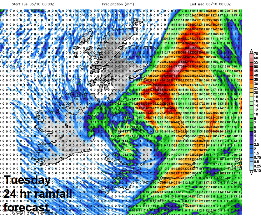
Back to today and the focus of the rain will be across NE England and SE Scotland along an occluded front wrapping around low pressure loitering just off the east coast of England today. These two areas could see up to 30-40mm by the end of today, locally perhaps 50-60mm. A Met Office warning for rain is in force for eastern England and far SE of Scotland. A strong northerly wind developing down the North Sea coasts here this afternoon, perhaps gales this evening. So feeling rather unpleasant and cool in the rain and wind.
The same area of cloud and rain will move back south across the Midlands, East Anglia and SE England this afternoon, after a mostly dry, bright or sunny morning. The wind strengthening from the north too. But elsewhere it’s a brighter and breezy picture with sunny spells and scattered showers across the west. Temperatures reaching 14-15C at best where we see sunshine, but under the cloud and rain in the east reaching only 10-13C at best.

Cloud and rain across the east will slowly clear away out over the North Sea, but it will remain windy in the east, with gales along North Sea coasts from NE England down to East Anglia. Otherwise a mostly dry night with clear spells, just a few coastal showers in the west. Turning chilly under clear skies, with winds falling light allowing temperatures falling to single figures away from the windier eastern coastal areas, low single figures across Scotland.
Watch ex-Hurricane Sam out in the Atlantic drag warm tropical air northeast towards the UK later this week
It should be a sunny start for many on Wednesday, thanks to a ridge of high pressure building north between today’s low clearing east into northern Germany and a large and deep low pressure system out over the Atlantic - the remnants of Hurricane Sam. For most it will be a dry day with sunshine, but turning cloudier in the west in the afternoon, with outbreaks of rain spreading northeast across Ireland, N. Ireland and into western Scotland, with patchy light rain drizzle developing around western coasts of Wales and England. Feeling warmer, temperatures reaching 16-18C across England and Wales, 12-15C across Scotland, N. Ireland and along eastern coasts.
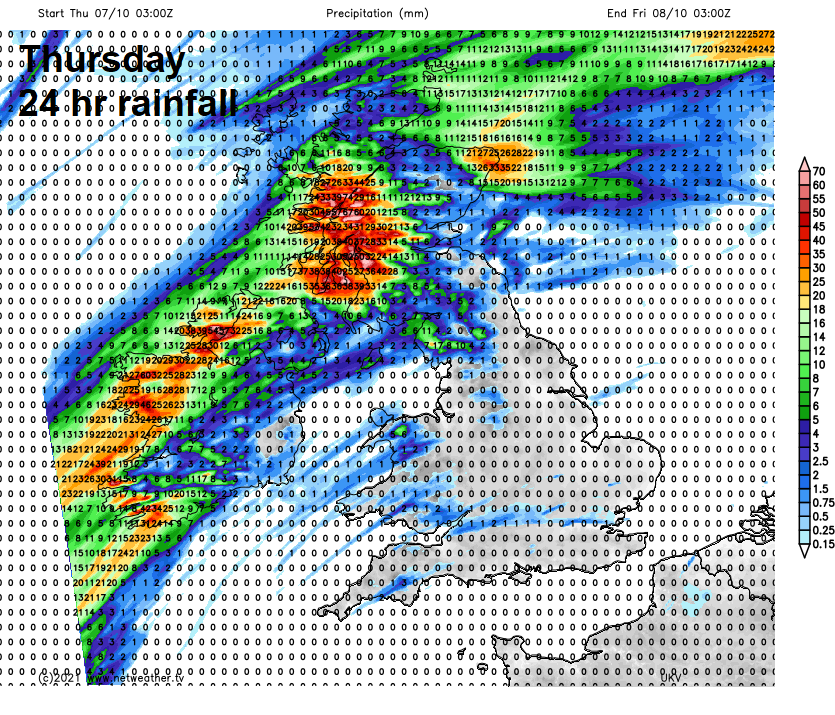
A slow-moving wriggling cold front across the far west and northwest will bring cloud and outbreaks of rain to Ireland, N. Ireland, northern and western Scotland on Thursday and Friday, windy too here with the remnants of Hurricane Sam to the northwest heading towards Iceland. The rain persistent and heavy at times in the far northwest and could bring some high rainfall totals leading to some flooding. Elsewhere, a warm front moving northeast off the Atlantic across mainland UK will bring more in the way of cloud to many on Thursday – though mostly dry away from northern and western hills. But behind the front warm air will be dragged from a long way to the southwest over the Atlantic, so feeling warmer, temperatures reaching 19-20C widely across England and Wales – helped by sunny spells, even the cloudier Scotland and N. Ireland reaching 17-19C. Temperatures quite a bit above average for October.