The autumn weather has certainly taken hold and there are more low pressures to contend with. The development of this weekend's low has uncertainty but could bring wet and windy weather to all.
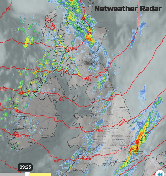
One large low pressure is sitting to the NW of the UK and its frontal rain will continue to sweep its way eastwards across England this morning. As we’ve already seen this week, there have been extra heavy downpours in line convection along this front and behind are clusters of heavy showers piling into Northern Ireland and western Britain. Strong west winds follow away from southern Britain.
Of particular interest is the next low pressure which will develop along the trailing front out in the Atlantic through Friday night. This will undergo rapid cyclogenesis as it moves up through Britain on Saturday. Sat 00z 1002hPa, 984hPa off Lands’ End Sat 12z, 970hPa nearly reaching John O’Groats Sun 00z and then continuing to deepen as it moves away to the north of Scotland, down to 963hPa by Sun 12z.
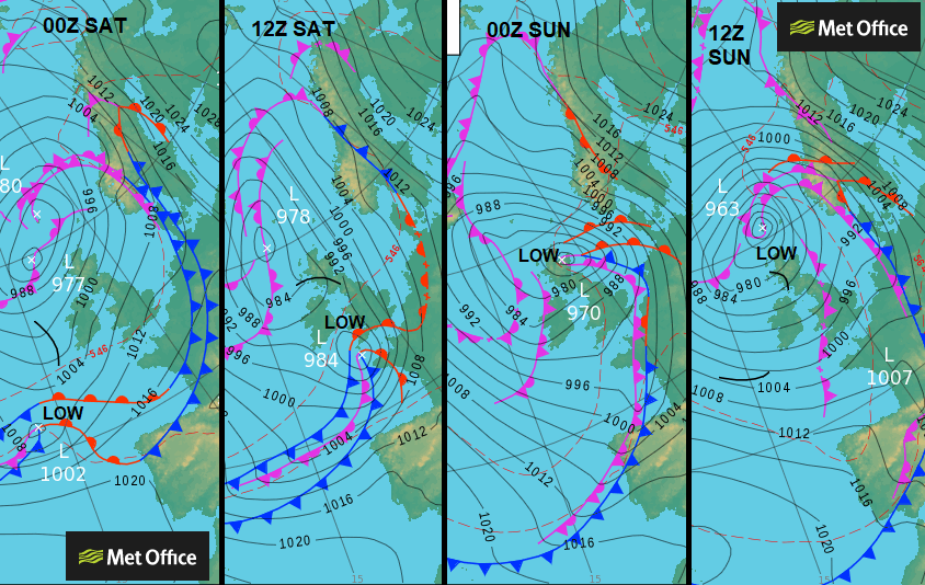
Usually, these low pressures move west to east, quickly across the UK but can bring vicious winds through say a morning. The track of this one means that Britain looks to have a longer spell of wet weather as the focus moves northwards, Saturday into early Sunday. Northern Ireland could miss the worst of the rain once bands of heavy showers have cleared in the morning. The jetstream will have a large meander over the UK at the weekend and steer the low northwards. When the emerging low engages with the strongest part of the jet will affect its development and so how severe the weather will be over the UK. And as it is the weekend, people maybe be out and about.
Around the centre of the low pressure, the winds will be light but slightly further away there could be wild conditions with strong winds and high gusts. As this low still has to develop, any slight change in track could mean that the high winds cause disruption on Saturday. By Sunday morning the far north of Scotland and the Northern Isles look most likely to be experiencing gales which could affect ferry crossings.
At the time of writing, there aren’t any national weather warnings out and so no named storm. If there is a shift for this developing low, there could be more widespread strong winds over the UK and even severe gales in places.
After Friday PM’s strong westerly winds over northern Britain and Northern Ireland the winds back to a southerly. They will be light over SE Britain but still gales for the Northern Isles with rough seas. Through Saturday morning the southerly winds strengthen through the Irish Sea and the English Channel. Moderate to strong southerly winds will reach up through Britain, gales for the Channel Islands and gusty over northern hills. On the current model run, there are signs that eastern Britain looks prone to stronger winds as the day continues, the southeast during Saturday evening. A veer and easing further west but still the uncertainty around the development of this Saturday low.
Currently showing cyclonic winds over Grampian with gales from the SE for Shetland during Saturday night. Then cyclonic for Northern Isles on a potentially wild start for Sunday in the far north as the low will still be deepening.
A band of heavy rain will clear SE Britain this morning as skies brighten behind. Another band of showery rain will continue eastwards too, and more sunshine appears during Friday., The strengthening west winds will drive showers (some with hail and thunder) over Northern Ireland, Scotland and NW England with plenty of wet weather for NW Scotland. Drier weather for Wales and much of England and parts of eastern Scotland with sunshine to end the working week.
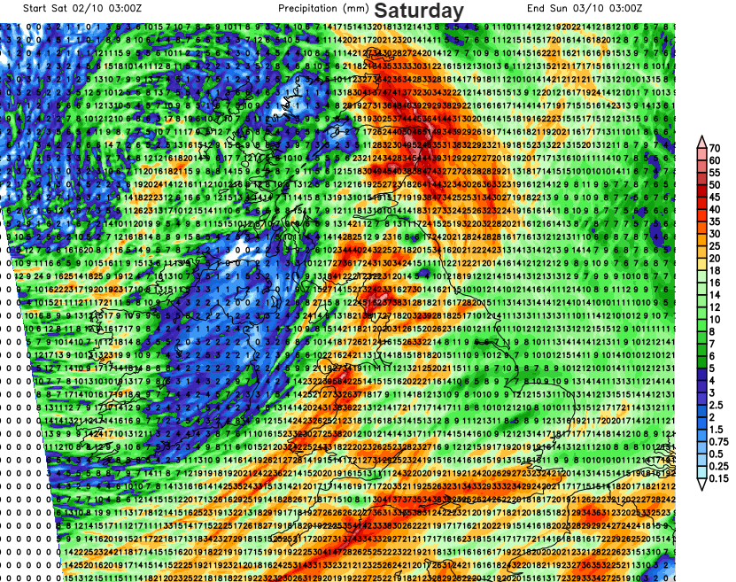
During the night as the winds back the showers extend their reach over western Wales and by dawn outbreak for SW England. Heavy frontal rain looks to move up from the SW on Saturday with outbreaks already ahead of this for western Britain. Again, there is uncertainty around the low position so keep the bigger picture in your mind if you have weekend plans. Don’t just focus on weather app symbols and timings. There does look to be heavy and persistent rain working its way north over Britain. This will be wrapped around the low centre in the far north by Sunday with sunshine and blustery showers over most of the UK.
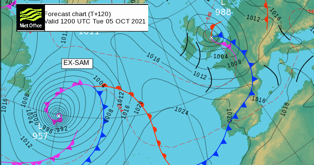
After that a lull for Monday before another low looks to develop for Tuesday with more wind and rain, then ex-hurricane Sam will be lining up out in the Atlantic.