Another mostly fine, warm and sunny day on Sunday. Heavy rain and squally moving in across the northwest later clearing east across all parts tonight and Monday morning. Followed by much cooler, windier and unsettled conditions for rest of the week.
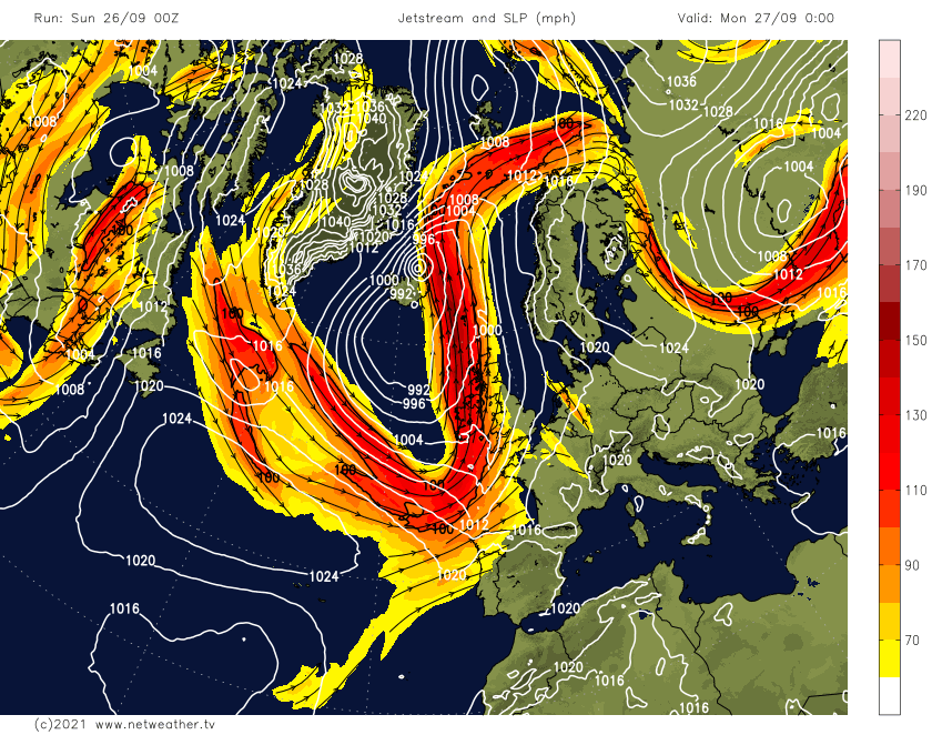
After a warm and mostly dry week for many, with many seeing temperatures into the low 20s Celsius where the sun came out, Sunday will bring another warm and dry day with sunny spells developing, however it will be the last of the run of warm days recently. It will turn wet and windy across Northern Ireland and western Scotland later, the band of cloud and heavy rain with squally winds along a cold front arriving here then moves in across the north and west tonight before clearing east across eastern areas Monday morning. This will herald a change to much cooler, unsettled and windier conditions across all parts in the coming new week, with a strong zonal jet stream across the Atlantic aimed at the UK and bringing a succession of low pressure systems throughout the week.
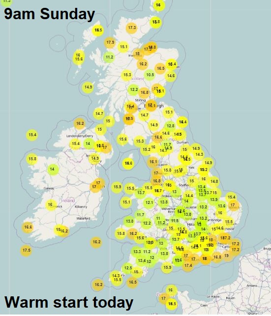
Sunday starts off on a mostly dry note, very mild too, with temperatures already 18C in the Moray Firth, but like the last few mornings, there is many southern, central and eastern areas of England area starting with low cloud, mist or fog. There are a few showers around across the northwest too.
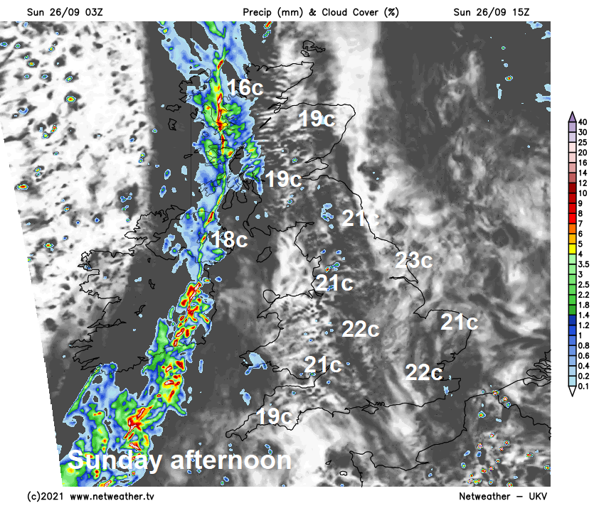
The murky conditions should lift through the morning with cloud breaking to allow sunny spells to develop for many, though the best of the sunshine will become increasingly confined to eastern areas this afternoon as western areas will become increasingly cloudy, with a band of heavy rain accompanied by squally winds spreading in across Northern Ireland and western Scotland, preceded by patchy light rain or drizzle across other western areas. Warm again in the sunshine, temperatures reaching 21-23C widely, across the cloudier far west reaching 17-19C.
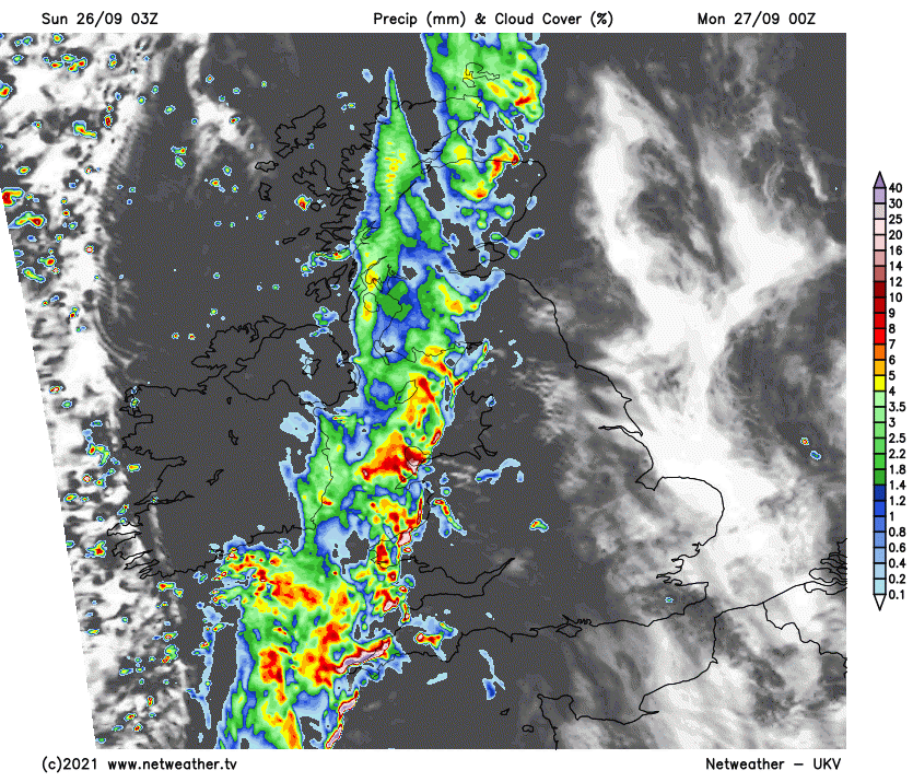
The band of heavy rain with gusty winds arriving across the northwest this afternoon will continue east across Scotland, northern England, Wales, Midlands and SW England this evening and overnight, clearer but cooler conditions arriving across N. Ireland.
A band of heavy rain and squally winds quickly clearing east across central and eastern areas of Britain Monday morning, bringing a tricky commute here, rain clearing out in the North Sea by lunchtime. Sunny spells but windy, cooler and fresher conditions following from the west for most areas, scattered heavy and thundery showers affecting western areas too, drier in the east in the afternoon. But no more temperatures in the twenties, we are looking at all areas reaching the mid-to-high teens Celsius at best, though this is closer the seasonal average.
Band of heavy rain clearing east on Monday morning
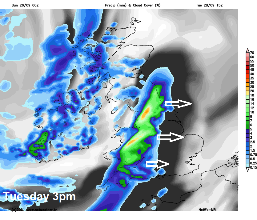
Tuesday looks to start off dry, fine and sunny across eastern Scotland and much of England, but there will likely be showers from the word go across the northwest, while an area of heavy rain will be pushing northeast across Wales and SW England during the morning. Outbreaks of rain, locally heavy, along with gusty winds, will then spread northeast across many areas through the afternoon – as a developing area of low pressure moves up from the southwest. Temperatures reaching 14-18C.
Heavy rain and squally winds clearing out into the North Sea Tuesday night, then a brief ridge of high pressure looks to build in across the UK for Wednesday, ensuring most areas see a drier and more settled day with sunny spells, just the odd light shower here and there.
The unsettled and often windy conditions look to resume on Thursday, as a deep area of low pressure swings northeast close to the northwest of Scotland. This will bring a spell of wet and windy conditions east across most areas through the day, followed by brighter conditions with showers across the north. Friday’s looking windy with showers or longer spells of rain across most areas, as another area of low pressure moves in across the northwest.