High pressure builds in across the south first half of this week, bringing fine & dry weather for most. But from mid-week, a strong jet stream arriving will introduce windier and more unsettled conditions in the north, with risk of gales Thursday.
Temperatures so far this month have been well above average across the UK, around 3C above normal for mainland UK – thanks to hot weather earlier in the month. However, after a fine start to the week with some sunny spells and warm afternoons, it will turn cooler later in the week with increasingly windy conditions taking over, with unsettled weather in the north, though staying mostly dry in the south. Temperatures becoming colder than normal across the north by the end of the week, around average in the south.
From high pressure in control early week to low pressure in control later this week:
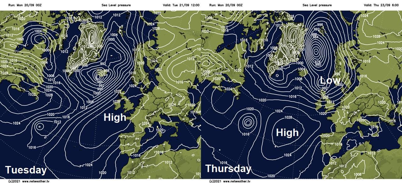
A ridge of high pressure building in from the southwest across southern Britain will ensure many will be dry over the next few days. Mornings will start off on the cool side, chilly in the north, but with sunny spells across many areas, the afternoons will feel warm in the sunshine. Changes from mid-week, as high pressure retreats and allows a strong jet stream coming out of northern Canada across southern Greenland to slip down towards northern Britain. The jet stream will bring low pressure systems southeast close to Scotland, tightening isobars across the UK, bringing cooler and windy conditions for the second half of the week, with gales likely in the north – along with spells of rain or showers.
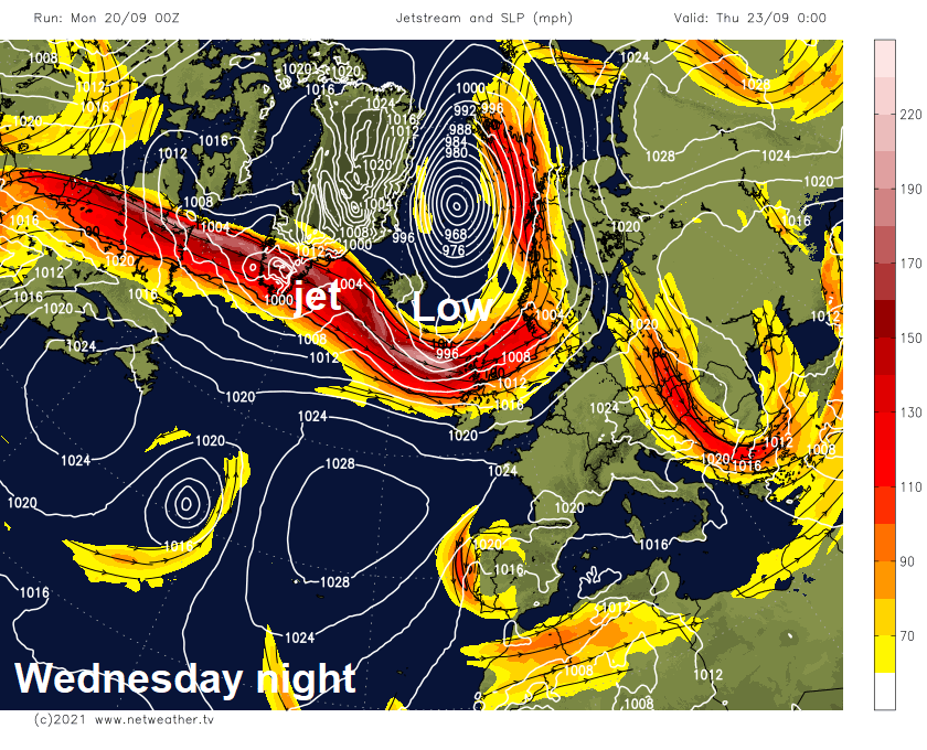
A strong jet stream ploughing across Scotland Wednesday night heralding windier and unsettled conditions for the north second half of this week:
For now, a mostly dry but bright or sunny start across Britain, chilly start in the north – with temperatures falling to around 2C in Cumbria and 3-4C across parts of Scotland and the far north of England overnight. Generally a cool feel for the morning commute or school run in the north and west with temperatures still in single figures in places. Some mist and fog patches to watch out for too, particularly in the west.
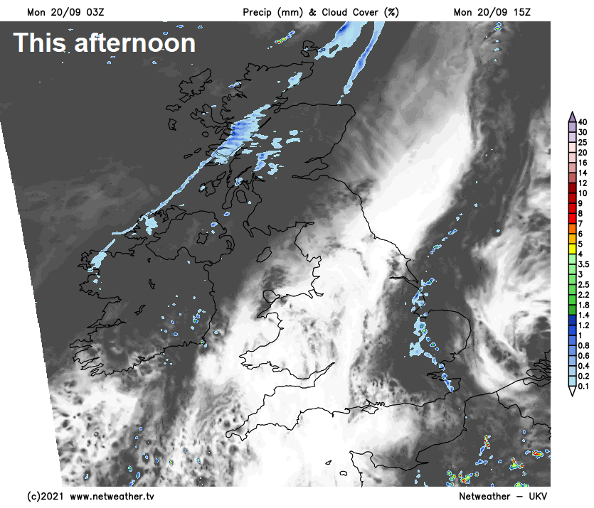
Milder across East Anglia and Kent this morning - with 15-16C at breakfast time the other side of a slow-moving warm front – which will bring cloudier skies and some showers at times here through the day, perhaps the odd heavy one here and there. Fronts moving in from the Atlantic will bring cloudier skies to Scotland and N. Ireland later this morning and through the afternoon, with spells of rain moving in across northern and western Scotland. Otherwise, for much of England and Wales it will be fine day with a good deal of sunshine. Temperatures reaching 15-19C across Scotland and N. Ireland, 19-21C across England and Wales.
Front bringing a band of rain of increasingly patchy rain southeast across Scotland and N. Ireland this evening, the front continuing southeast across England and Wales overnight, but weakening with rain fizzling out as it moves into high pressure building from the southwest, so bringing no more than just cloudier skies. So, for most, a dry night. Patchy mist or fog forming where skies clear. Another cool night, single figures in the north and west where skies clear.
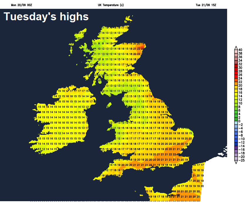
High pressure continues to build from the southwest across southern areas on Tuesday, so for most it will be a dry day with sunny spells. The exception will be western Scotland and N. Ireland – which will see a warm front arrive off the Atlantic, bringing thicker cloud and some patchy light rain. Turning windy in the far northwest too. Pleasant in the sunshine, temperatures reaching high teens to low twenties generally.
Wednesday is the Autumn Equinox and uncannily the weather is set to turn more autumnal from mid-week, particularly in the north of the UK. High pressure will slip back southwest, allowing a deep area of low pressure to sweep close to the Northern Isles Wednesday night, so isobars will tighten bringing a windier day, especially in the north. A band of heavy and squally rain will slip southeast across Scotland during Wednesday, weakening as it arrives across northern England in the evening. Brighter and cooler conditions following the front, but with squally showers across NW Scotland. To the south of the front, mostly dry and bright but breezy.
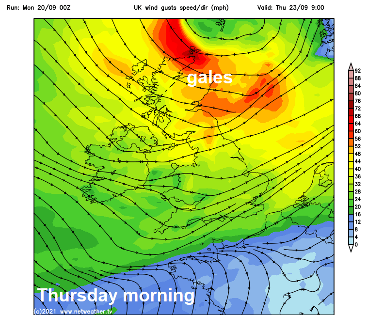
Gales possible across Scotland Thursday morning, as that deep low sweeps east near the Northern Isles, otherwise a windy and cool day with showers in the morning across the north merging into a longer spell of rain. The south again mostly dry and bright. Friday looks like seeing a brisk westerly wind which will bring scattered showers in the west, mostly dry and bright in the east.