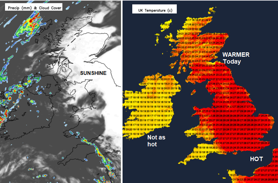
It is unusual to see temperatures over 30C in September for the UK. It happened on Tuesday and is forecast again today. Changes are afoot with more cloud and heavy, thundery downpours edging in.
Another hot day across Britain midweek with a top temperature of 30C possibly 31C forecast inland. This after a muggy night. It was really warm in places with 20C+ which is called a “tropical night” in the UK. Ceredigion saw 30.7C by day on Tuesday with Gogerddan recording the highest UK temperature. It is unusual to see temperatures this high in September.
“This will be the 7th time in the month of September that temperatures have reached in excess of 30 Celsius in the UK in the last 50 years” Met Office
Co. Clare and Co. Kerry both saw 27.9C, the top temperatures for southern Ireland with glorious sunshine. However already this morning there is more cloud.
Changes are on the way and already there is more cloud from the west with elevated thundery showers. This showery incursion will develop during the day with thunderstorms and heavy downpours moving up from the southwest. Gradually over the next day or so, the heat will ease, low pressure moves over the UK and the weather becomes more mixed with showers and more cloud.
Scotland has less cloud today and so with more sunshine, temperatures will be higher here today. Well up into the 20sC with Strathclyde and Aberdeenshire seeing 27 or 28C. The Western Isles and NW coast stay grey and damp with rain beginning to gather itself later today, extending around the Northern Isles from a waving front.
Northern Ireland saw a top temperature of 26.3C in Armagh yesterday with 21 to 23C being forecast widely today. There will be a light east to SE wind, more cloud and outbreaks of showery rain as the day goes on.
For Wales, there will be heat again, more so for eastern areas. Temperatures will range through the 20sC as cloud increases and showers move in. England starts with a lot of sunshine, some early mist but there is already thunderstorm action down to the SW.
Jersey saw a top temperature of 30.6C on Tuesday but won’t be that hot today. Already there has been heavy rain and thunderstorms. Meteo France has thunderstorm and heavy rain warnings as does Met Eireann.
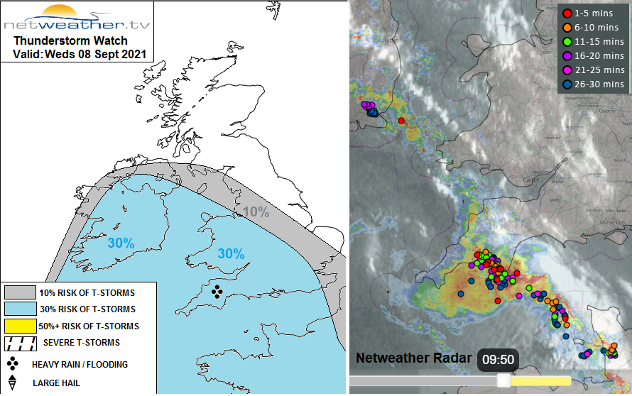
Our Netweather thunderstorm forecast includes Northern Ireland, Wales and a good portion of England away from the NE. Plymouth has seen lightning, heard thunder and the rain has certainly arrived.
"...will develop sporadic deep mid-level convection with elevated heavy showers and a few thunderstorms affecting southern Ireland, SW England and S Wales through the morning and into the afternoon. This activity extending further N and NE across Ireland, Wales, NW, central and S England Weds evening/night. Any of these storms may produce frequent cloud-to-ground lightning, torrential rain leading to flash-flooding and localised strong wind gusts. Storms will likely be quite localised."
Further thundery or heavy bursts will appear in the western half of the English Channel this morning, with bands extending into SW England, SW Wales and Northern Ireland. There will be some interesting cloud patterns today. Ahead of all this, there is more heat, more sunshine and quite incredible weather for this time of year.
However, if you do get caught in a thundery downpour you’ll get soaked. There is the risk of flash flooding, poor visibility and of course the lightning strikes. The Met Office thunderstorm warning highlights developments late afternoon into the evening for SW Britain. Heavy showers and thunderstorms will be edging eastwards over southern England this evening and then northwards into the night. Keep an eye on the Netweather Radar.
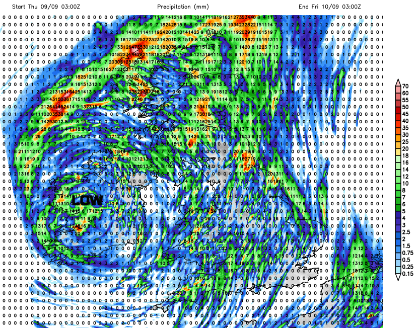
By Thursday there will be more cloud and more showers across the UK. Western areas seeing more rain and cloud, eastern Britain still managing to keep some warmth and brightness. East Anglia will still be in the mid 20sC. There is still the risk of thunderstorms and heavy downpours.
The temperatures settled around the low 20sC for the rest of the week, even dipping into the high teens by Sunday. Next week looks settled again but not as warm and certainly cooler by night.