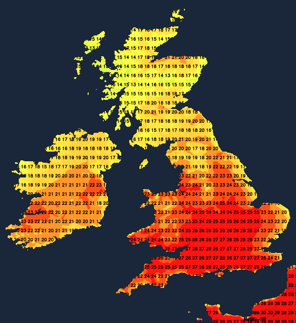
Summer weather is making a comeback over the coming days, with temperatures rising into the high-twenties, even low-thirties by midweek.
With high pressure now to the East bringing drier air off the nearby continent, we're getting rid of the gloom that has plagued many eastern parts for weeks. It's also becoming warmer, with some, no doubt, welcome rain today for the North and West of Scotland and Northern Ireland, where it's been so dry recently.
Much of the coming week will be very warm or hot - warmer than in August, in fact. Before showers, some of them heavy and thundery, edge in from the West later in the week.
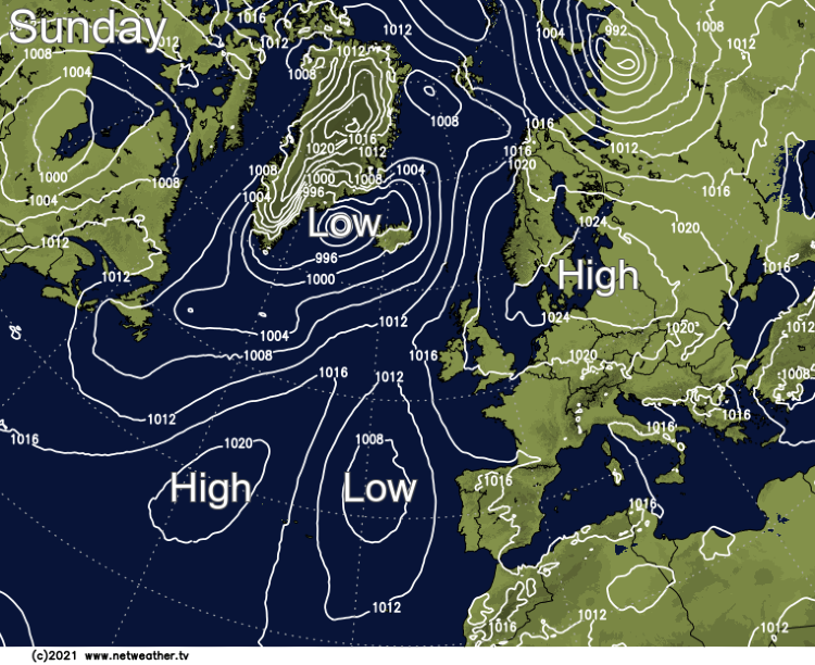
For most, we have a mix of mist, patchy fog and low cloud first thing on Sunday, but some hazy sunshine as well. The mist and fog will quickly clear with patchy cloud, mainly in the East, tending to clear through the morning, to leave most of England and Wales fine with spells of albeit somewhat hazy sunshine. It'll become very warm locally hot over parts of southern England in a light Easterly breeze, with maximum temperatures mostly in the range 19 to 24C but locally 25 or 26C in the South. The exception will be the far South West where sea mist and low cloud will plague some coasts.
We already have a few showers over West Scotland where here, together with Northern Ireland and the North of Scotland, cloud will move in from the West, bringing the first rain for a while that'll be heavy in places. But over eastern Scotland, it should remain fine and dry for much of the day. A South Easterly wind will freshen a little in the West, with top temperatures here 16 to 19C, while 20 to 22C is likely further East.
During the evening and after dark, the rain becomes lighter as it moves East and South, to be lying across northern England and the south of Northern Ireland by morning. Further North, it becomes drier, but it remains somewhat cloudy, and it becomes misty by morning in mostly light breezes. The odd shower can't be ruled out in the South and South-West, but the remaining parts of England and Wales stay fine with clear intervals. Light winds allow mist and patchy fog to return, but in a very mild night across the country, temperatures fall no lower than 10 to 16C.
It's back to school on Monday with the new working week, ironically, bringing the return of summer for the southern half of England and Wales. Here mist and patchy fog will lift to leave a lovely, very warm, even hot day, with spells of hazy sunshine raising temperatures to 23 to 26C even a hot 27C locally. The patchy rain over Northern Ireland and the North of England will peter out, allowing skies to brighten, but here together with much of Scotland, you'll probably keep a lot of cloud. Top temperatures here 17 to 21C in primarily light winds across the country that'll be between East and South.
A weak front may bring patchy drizzle to parts of Northern Ireland and western Scotland, but for most, a dry, very mild, even rather warm evening and night will follow. There'll be patchy cloud but clearances also, with light winds allowing murk, mist and patchy fog to reform again. It may also feel slightly humid, with temperatures across the country unlikely to fall below 12 to 17C.