Storm Evert brought a wild night to SW Britain, particularly Cornwall. This low will move across southern Britain today with heavy downpours and strong winds for English Channel coasts.
It’s been a wild night for Cornwall and other exposed parts of SW Britain. A rapidly deepening low pressure, Storm Evert moved in overnight bringing heavy rain and gales. Campers in Cornwall have had a disturbed night with gusts over 60mph and the Isles of Scilly reported a gust of 69mph. The low pressure will move steadily across southern Britain today, clearing from East Anglia this evening. There will be bands of heavy rain and thunderstorms over Wales and England today, but the weekend looks quieter.
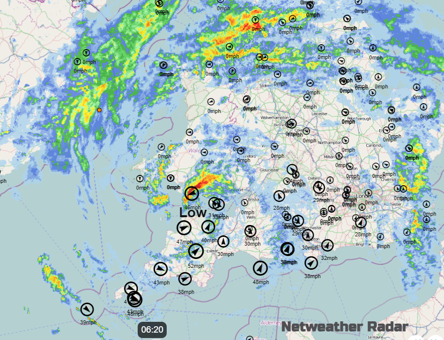
Storm Evert was named by the UK Met Office yesterday with an amber warning over Cornwall and the Isles of Scilly for the strength of the wind and potential impacts due to the high winds. The names are given by three Met Offices in the Western European naming group, this name being Dutch from KNMI. That amber warning has now lapsed but there are yellow wind warnings along the south coast today.
“Windy weather on Friday may lead to some travel disruption… including coastal gales for some, will develop across southern and south-eastern England early on Friday, spreading into North Sea coastal areas during the late morning and afternoon. Gusts of 40 to 50 mph are expected quite widely with gusts of 55 mph … most exposed coastal areas. “MO
Fresh to strong SW winds will affect the south coast of England this morning with brisk north to westerly winds following behind the low centre, for Wales and north Devon. As the yellow warning shifts from SW Britain to SE England during the day, the strongest gusts edge eastwards along the Channel coasts.
If you are getting a ferry from Dover or Ramsgate today, it could be quite lively this afternoon.
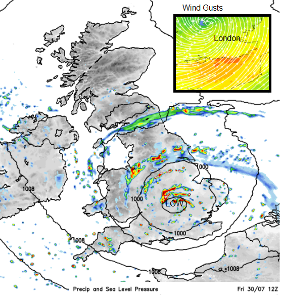
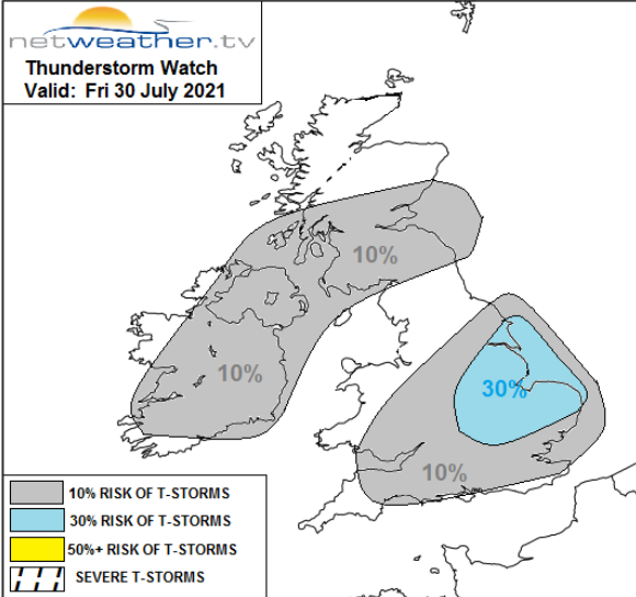
There will be more rain today. There have been several district heavy bands overnight which have reached over northern England, the Isle of Man and Wales this morning. By this afternoon it will be more showery with the risk of thunderstorms. The heaviest downpours will affect central parts around lunchtime but focus on eastern England this afternoon as the low centre moves by. From the Humber down to the Thames.
Convective forecast - "locally intense convective rainfall which may increasingly be accompanied by lightning as surface heating increases cloud depth. Main risk area for a few thunderstorms appears to be across S/E Midlands, Lincs, E.Yorks & East Anglia – where greatest instability is forecast, though some more modest instability from insolation allowing heavy convective downpours to develop further south across S England. Localised flooding from some of the intense convective thundery downpours is possible, while any storms that form towards SE England may produce some strong convective wind gusts."
Northern Ireland and Scotland remain mostly unaffected by the windy weather and heavy rain from this storm today. There will be a few sharp showers for the Southern Uplands and western counties of Northern Ireland. Temperatures here will be 16 to 20C with light winds although it will begin to feel fresher as the north to NW breeze takes hold this afternoon. There will be some cooler nights this weekend with even a touch of grass frost for a few inland rural spots in northern Britain.
Saturday starts off fair, quite a different morning to Friday’s. There will still be a scattering of showers, for Cornwall, NW Wales and coming down the North Sea on the fresh breeze, for NE England. These showers move southwards over North Yorkshire to Lincolnshire with a rash of showers breaking out across southern Britain.
Sunday should see fewer showers after a cool start. In the sunny spells, it will feel warm, the August sunshine is still strong, but air temperatures remain in the high teens to low 20sC. So, no sultry evenings to sit lingering outside.
Storm Evert discussion thread in the Netweather Forum