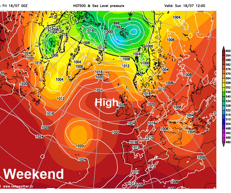
High pressure in charge of our weather through the weekend and into early next week, peak of the heat likely on Sunday, when 30C maybe reached in the southeast, cooling of early next week.
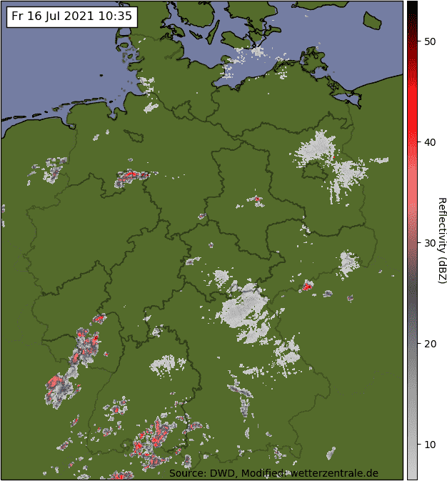
Firstly to the serious flooding in Germany and Belgium, this morning in Germany it’s been reported that 81 people have died while another 1,300 people are missing. While the death toll in Belgium has risen to 11 people. There is also serious flooding in parts of Holland downstream of the rivers bringing flooding to Germany and Belgium. Over 3 months’ worth of rain has fallen in the space of 2 days in the areas affected by flooding, 250mm of rain falling in 48 hours in some spots. An area of low pressure stuck and moving little over central and northern Europe during the week the culprit, with a stationary area of heavy rain falling over eastern side of Belgium and western Germany. The same low pressure system brought torrential downpours and flooding to parts of London earlier in the week on Monday. Although there were some prior warnings in place in Germany and Belgium, it seems that the flooding took hold so quickly that people were caught out.
It looks like there will be a little more rain in the form of showers across the areas affected this morning before they ease south by the afternoon. Fortunately high pressure building over the UK will extend east across the Low Countries and Germany into the weekend, bringing a drier spell of weather which should last through most of next week too.
Back to the UK, it’s been a drier picture for the second half of this week, as a ridge of high pressure builds in from the Azores. A cool and blustery northerly or northeasterly wind kept eastern areas cooler and with more in the way of cloud yesterday, with western areas seeing the best of the sunshine and the highest temperatures. Northern Ireland was the warmest spot, with Castlederg seeing the UK’s highest temperature of 25.7C, making it the warmest day of the year so far for N. Ireland.
Although we keep a northerly breeze in eastern areas today, which will bring cloudier skies across SE England and East Anglia at first this morning, it be a warmer day here with more in the way of sunshine developing than yesterday. London should reach 26C. Windy but dry for the The Open golf at Sandwich in Kent, after a cloudy start it should turn sunnier, temperatures reaching 19C, the wind could prove challenging though
.
It will be dry with plenty of sunshine for most today, thanks to high pressure centred across Ireland. Again, highest temperatures will be towards the west, reaching 27C in Cardiff. But elsewhere will be warm too, reaching 21-26C, though cooler around coasts. Northwestern areas will see more in the way of cloud though, particularly across western Scotland and parts of N. Ireland – which will see thicker cloud with patchy drizzle.
The weather will remain generally dry as we head into the weekend, thanks to high pressure in charge, while it is set to turn increasingly warmer too, with less cloud and longer spells of sunshine. Sunday probably the hottest day.
Saturday will be dry and sunny with some fair weather cloud across England and Wales, becoming very warm with temperatures 25-28C widely inland, cooler around coasts. Still that pesky cloud and patchy drizzle affecting western Scotland and perhaps the north coast of N. Ireland, but eastern Scotland sunny with Aberdeen reaching 25C.
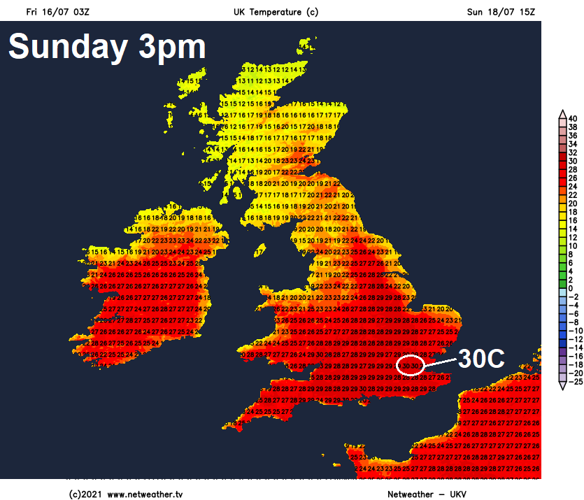
Sunday will continue sunny and very warm across England and Wales, hot in the south, with 30C possible in the southeast – which will make it the warmest day of the year so far, currently June 14th is the hottest day this year so far, when 29.7C was reached at Bushy Park in London. A weak weather front draped across the far north will mean Scotland and the north coast of N. Ireland will see more in the way of cloud, thick enough to bring the odd spot of rain or drizzle over the Highlands.
The fine and settled weather looks to continue well into next week too, as high pressure holds strong over the UK. The peak of the heat from this drier, warmer and settled spell will be this weekend. Subtle changes in high pressure position will mean Monday and Tuesday seeing more in the way of cloud spreading south across northern and eastern areas, which will produce a few light showers, western areas seeing the best of the sunshine, perhaps hitting the mid-20s Celsius here, but temperatures generally back in the low twenties Celsius. High pressure drifting east from mid-week, so perhaps cloudier towards the west and sunnier in the east on Wednesday and Thursday. A risk of some showers moving into the southwest and west from Thursday, as low pressure moves in to the west, signalling a breakdown to more unsettled conditions for all by the end of the week, with a risk of thundery showers breaking out for many. But some uncertainty on this.