It's been a long wait, but high pressure is now back in charge of the UK's weather and will be staying that way right into next week. Temperatures will be on the rise too, with the heat probably peaking on Sunday and Monday with maxes reaching the low-thirties Celsius.
It's been a long wait, but high pressure is now back in charge of the UK's weather and will be staying that way right into next week. Temperatures will be on the rise, too, with the heat probably peaking on Sunday and Monday with maxes reaching the low-thirties Celsius.
Today (Thursday), we have a weak front moving south through England and Wales, bringing some extra cloud. It's already cleared out of Scotland, though, so away from western and northern fringes, it'll be a day of virtual wall to wall sunshine here. And, the cloud will thin and break in England and Wales as the day wears on as well, bringing some long sunny spells.
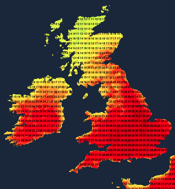
The wind will be a fairly noticeable feature, blowing in from the west or northwest down the western side of the country and the northeast for in eastern and central regions. Today's warmest places are likely to be near to southern coasts of England and Wales, with highs of 24-26c typically. Elsewhere, 22-25c will be about the limit inland but cooler in other coastal regions with those onshore breezes.
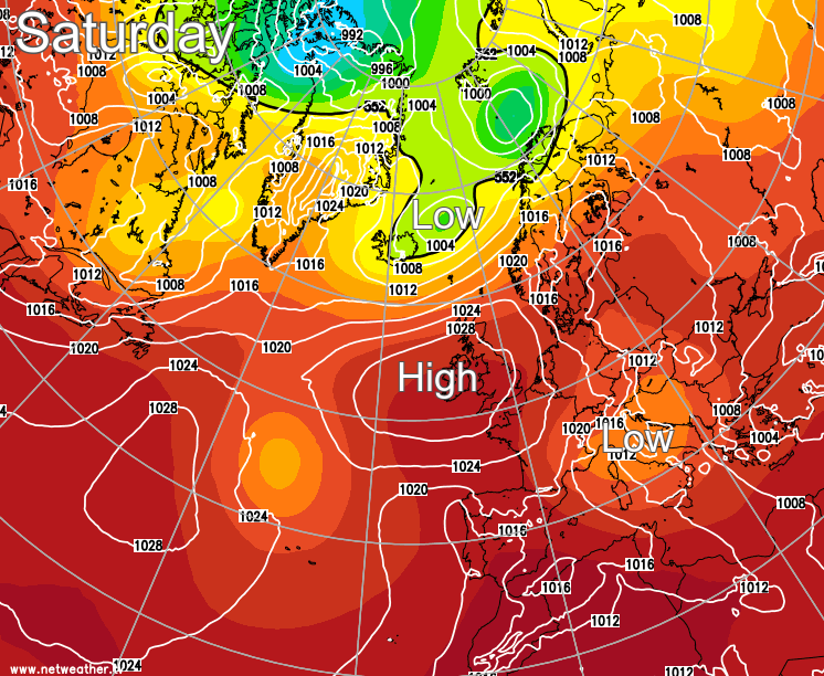
From tomorrow and into the weekend, the wind will become lighter, with the notable exception of Scotland. Here, with the pressure gradient between the high over the UK and low pressure close to Iceland, there'll be a keen westerly wind. It'll be most noticeable across the North but will generally keep much of Scotland a touch cooler than England and Wales, with more cloud in the west and north as well. A similar issue is also likely to affect the far southeast tip of England and east of East Anglia. This time, it's the gradient between the high over the UK and low pressure near Italy, just tightening the isobars to strengthen an onshore breeze.
Everywhere else will see increasingly warm, if not hot temperatures from Friday and through the weekend, though, with blue skies almost all the way, inland. Temperatures on Friday will peak at 24-27c in central and southern England, while other parts reach 21-24c generally. Eastern, Western and north-facing coasts will be a touch cooler, with northwest Scotland seeing more in the way of cloud and maybe even some patchy rain at times.
Saturday sees another rise in temperature, with 30c potentially being breached in a few spots, but typically maxes of 24-28c will be likely in all parts away from western and central Scotland, where it's liable to be cooler and cloudier. Sunday is likely to bring another step upwards, with a peak of 30-32c or so not out of the question, with similar values possible on Monday too.
It won't just be temperatures climbing higher through the rest of this week; both pollen and UV levels will be into the high or very high category.