


It's been a long time coming, but high pressure is on the way this week to finally bring some settled, warmer weather to the UK. Today (Monday) will be the final really unsettled day, with steady improvements from Tuesday onwards as pressure slowly rises across the country.
It's been a long time coming, but high pressure is on the way this week to finally bring some settled, warmer weather to the UK. Today (Monday) will be the final really unsettled day, with steady improvements from Tuesday onwards as pressure slowly rises across the country.
For now, we have low pressure well in charge - it's thrown fronts north over the last 24 hours, bringing persistent rain up from the south, some of which is still affecting northern England this today. It's not going to move a great deal through the day but will tend to ease from the southwest and rotate around into parts of eastern Scotland later on.
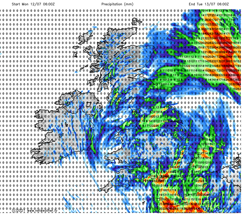
Although a few sharp showers are possible just about everywhere, it's to the south of the more general rain where most of the real action will occur today. Southern England and East Anglia are nearest to the low, which is just over the continent and moving slowly east, and it's where the atmosphere is most unstable. Here, there could be some torrential downpours through the day, with some lively thunderstorms a possibility. As always, not everyone will be in line to catch the worst of them, but affected places could see 50mm of rain or more in a relatively short period of time, which is plenty enough to cause some flooding, issues with surface water and disruption on the roads.
The rainfall total map for the next 24 hours shows where the wettest locations are likely to be - it also highlights how localised the hotspots may be - and with these things being very tricky to forecast, they may be in different locations to those shown - the best option for staying up to date is to track the latest on the rainfall radar.
The rain and showers will slowly ease back through the evening and overnight to leave just a few showery bits and pieces of rain in amongst a lot of cloud on Tuesday morning. West is likely to be best for sunshine (that's going to become more of a theme through the week), and there'll just be a scattering of showers likely to develop through the day. Nothing like we'll have seen on Monday, with most places staying dry with some brighter, sunnier spells breaking through the cloud at times.
With high pressure starting to really establish itself on Wednesday, there'll be ever more fine, sunny and warm weather to be had. With temperatures climbing up into the low or mid-twenties quite widely across the UK. Ireland (North and South) will be cloudier, though, and there could even be a few outbreaks of rain clipping Northern Ireland and running into western Scotland later in the day, as a weak weather front pushes over the top of the high pressure, which will be ridging up from the southwest.
The weather front will still be in play on Thursday, bringing more cloud down from the northwest and maybe just helping to fire up a few showers as it moves southeast. By Friday, that should have cleared, though, with many parts sunny and warm. Although by this point, there will be an onshore breeze affecting eastern coastal counties, keeping more of a lid on temperatures and bringing some cloud and murk inland at times.
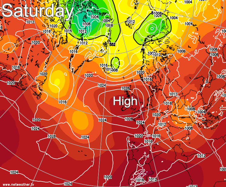
High pressure will be well in charge at the weekend, centred right over the UK. That means a continuation of the fine, dry, warm weather for the vast majority. But with winds from the east, those eastern coastal regions in England are still likely to see more cloud and cooler temperatures, with some of that cloud perhaps making it a good way inland at times.


