Further pulses of heavy rain will move up from the south in the coming days with the threat of torrential downpours from thunderstorms.
Quite a change overnight after the thunder and lightning show for the southeast. There were incredible cloudscapes as the main thunderstorm cell arrived at the coast of Kent on Wednesday evening. There has been heavy rain overnight, torrential at times and there is a lot of cloud lingering this morning. The air is humid, but it doesn’t feel as hot under those grey skies, just muggy. Heathrow reached 29.2C yesterday.
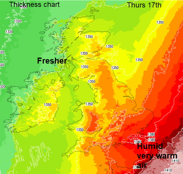
Today a lot depends on cloud breaks. Temperatures across the UK will be in the high teens to low twenties Celsius with fresher, cooler air edging over more of Britain behind a weak cold front. Ahead of this, for SE England and East Anglia, in any sunshine, the temperatures will leap up to around 27C. This extra energy combined with high dew point air, large CAPE and signs of breeze convergence this afternoon brings the risk of isolated surface-based thunderstorms brewing up.
Again, with the risk of:
“large and damaging hail (3-4cm), frequent cloud-to-ground lightning, strong wind gusts (30-40 knots) and torrential rain leading to flash-flooding.” Convective Forecast
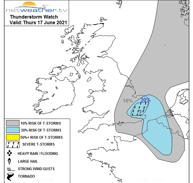
The UK Met Office has a yellow warning for Thunderstorms out for today. “Some places may see thunderstorms today which may lead to travel disruption and flooding.”. And another one for Friday overnight into Saturday morning. This one covers a larger area, reaching across to East Wales as there is some uncertainty about where the pulses of storms will end up pushing northwards through. These yellow areas give an idea of where is at risk from the severe weather but not everyone will see a thunderstorm or downpours. The risk is there but you could stay dry or get drenched. Looking at the storms from last night (below), they progressed north-eastwards, but other areas missed out, all still within the warning area.

The further northwest in the UK you go, the less complicated the forecast. There is a lot of fine, dry and bright weather about. It does feel fresher in the shade but warm in the strong sunshine. Temperatures for Northern Ireland, Scotland, northern England and much of Wales will be around 15 to 20C today. South Wales looks warmer. There is just a light breeze from the west and a fair day to come.
For the rest of England, temperatures will range from 20 to possibly 27C depending on the sunshine. There is patchy rain on the cold front over NE England, more rain over the Channel Islands too. This weakening band will edge eastwards lining up from The Wash to the Isle of Wight by lunchtime, with its cloud cover. A large thunderstorm is working its way into the southern North Sea bit there is still a hang back of early rain over coastal counties through Essex down to Sussex. All of this moves northwards, brushing Norfolk and then we’ll see if the storms get set off.

The frontal boundary links down from London through western Europe to Algarve by tonight. Hot, humid air to the east of this as a low pressure develops over western France. It pulls some cooler north to NE air over the UK and temperatures fall well into single figures for Scotland and Northern Ireland with clear skies. This low moves north towards Kent during Friday with a brisk NE wind but the heat looks to remain just across the Channel, hot for France.

However heavy, thundery downpours will spin off the low pressure and bring the threat of torrential downpours. These look to work their way northwards during Friday but the uncertainty of how far west they will extend and if they miss the southeast, taking a more central path remains.
Saturday looks quiet and fair with further potentially thundery pulses arriving from the south on Saturday night and working their way north through the UK on Sunday with quite an easterly wind picking up.