Cloud and some rain will plague the north & west at times this week, while southern & eastern areas enjoy very warm & sunny conditions. Turning humid for all from Wednesday & the dry, sunny and very warm weather expanding north this weekend
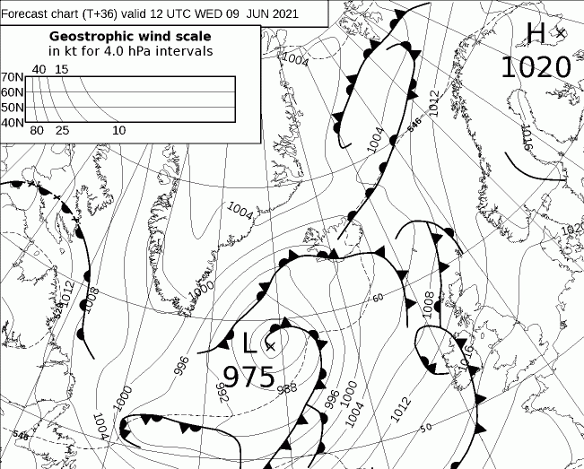
With low pressure close to the northwest and high pressure close to the south, the north and west will be breezier and see more in the way of cloud at times for the rest of the week, while the south and east will see sunnier and drier weather. Highest temperatures will be across the southeast – where we could see the high 20s Celsius, reaching the low to mid-20s elsewhere. But for everyone, it will become more humid by day and night, as a long-fetch southwesterly flow draws in warm and moist subtropical air from the mid-Atlantic.
Humid air being pulled in across Britain from the subtropical Atlantic from mid-week, making it muggy day and night
High pressure close to southern Britain to end this week will build further north across Britain over the weekend, so Scotland and N. Ireland that haven’t faired so well with the fine weather this week will join England and Wales to see sunnier and warmer weather over the weekend, it will be hot across eastern England – with temperatures reaching the highs 20s Celsius, maybe a 30C in a few spots. High pressure looks to remain close by early next week, so the fine and very warm or hot weather continuing for many, some uncertainty as would be expected this far out, but it looks like there may be a breakdown of the fine and settled weather from the Atlantic from mid-week.
For today, some mist and low cloud around some coasts to start the day, otherwise England and Wales will have a mainly dry and sunny day, a little warmer too, with temperatures reaching 20-25C. Scotland and N. Ireland starting the day mostly cloudy, away from the east, with some patchy light rain or drizzle for western Scotland and N. Ireland. Most of Scotland and N. Ireland brightening up with sunny spells developing. Warm and muggy, with temperatures reaching 18-22C.
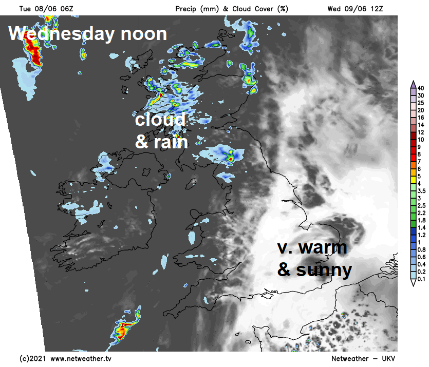
Increasingly humid as we head into Wednesday, as a strengthening southwesterly breeze drags in sub-tropical air from way to the southwest over the Atlantic. This increase in moisture does mean there will be more in the way of cloud than today across northern and western areas – aided by a wriggling weather front moving in from the west lifting the warm moist air into cooler air aloft, bringing some patchy rain, heavy at times in the northwest. But for southern, central and eastern England it’ll be another fine and sunny day – temperatures reaching 22-26C. Staying warm and humid Wednesday night, temperatures widely falling no lower than the mid-teens, so perhaps a more uncomfortable night’s sleep than we’ve been used to.
Wriggling weather front towards the northwest will bring cloudier skies and outbreaks of rain to the north & west Wednesday
The jet stream will be running northeast just north of northern Scotland through much of this week and will strengthen through Thursday and Friday. This will bring breezy conditions in the north and will pull those weather fronts close to the northwest further east, weakening as they do, but bringing more in the way of cloud further east, particularly Thursday. Likely staying dry in the east with some very warm sunny spells developing towards eastern England after perhaps cloudy starts both days, but northern and western areas remaining often cloudy and seeing some patchy rain again Thursday, Friday drier. Where the sun comes out, temperatures reaching 25-26C, even where it stays cloudy – temperatures in the low 20s Celsius and everywhere feeling humid day and night.
Watch the upper level ridge (deep reds of 500 hPa heights expanding) strengthen across Britain into the weekend
An upper level ridge and surface high builds further north across Britain on Saturday, as a result of the strengthening jet stream to the north pulling northeast increasingly warm air / increasing geopotential heights aloft. So, becoming dry for all and correspondingly it looks like most places will become sunny too after any early low cloud burns off. With less cloud around it will be warm or very warm across the board, locally hot towards eastern England – where we could reach the high 20s Celsius. Plenty of sunshine looks likely again on Sunday across more southern and eastern areas, though with high pressure retreating, this may allow the odd isolated shower to develop, as temperatures reach the high 20s Celsius again. Cloudier towards the north and northwest.
Hints from the models of a change to more unsettled conditions, but still warm, middle of next week, below is the ECMWF ensemble mean for sea level pressure for early Thursday next week - blues are lower pressure against climatology
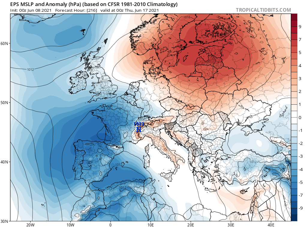
A ridge of high pressure hanging on close by early next week, continuing the fine, sunny and warm or very warm conditions for most away from the far northwest – where it may be cooler, cloudier and breezier. But hints of a change perhaps from mid-week, with ECMWF and GFS ensembles pointing at high pressure retreating to allow low pressure to move in the northwest and/or southwest. The ECMWF ensemble mean, below, showing low pressure to the northwest and southwest, high pressure retreating to the east.